


E1-giros-toy-or0u

cros45
User
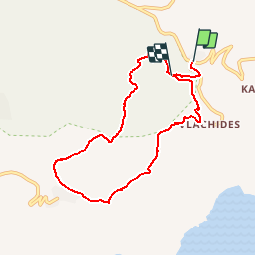

Length
8.9 km

Max alt
461 m

Uphill gradient
413 m
Km-Effort
14.2 km

Min alt
190 m

Downhill gradient
364 m
Boucle
No
Creation date :
2019-03-06 08:19:54.238
Updated on :
2019-03-06 12:12:00.787

FREE GPS app for hiking
 SityTrail
IGN / Geographical institutes
SityTrail World
The world is yours!
About
Trail of 8.9 km to be discovered at Attica, Regional Unit of Islands. This trail is proposed by cros45.
Positioning
Country:
Greece
Region :
Attica
Department/Province :
Regional Unit of Islands
Municipality :
Unknown
Location:
Unknown
Start:(Dec)
Start:(UTM)
720790 ; 4176200 (34S) N.
Comments
Trails nearby