Trail On foot Cournols - Cournols - Photo
© OpenStreetMap contributors
Length
Length
10.6 km
Max alt
Max alt
962 m
Uphill gradient
Uphill gradient
269 m
Km-Effort
Km-Effort  
14.2 km
Min alt
Min alt
760 m
Downhill gradient
Downhill gradient
266 m
Boucle
Boucle
Yes
Creation date :
2019-02-28 10:17:18.548
Updated on :
2022-12-29 15:47:36.417

(0 Reviews)

On foot
On foot
--
Difficulty : Very easy
Walking
Walking
3h13
Difficulty : Difficult

Scan this QR Code to open this trail in the SityTrail application

FREE GPS app for hiking

Logo SityTrail SityTrail

IGN / Geographical institutes

Download SityTrail from the App Store Download SityTrail from Google Play

Logo SityTrail SityTrail World

The world is yours!

Download SityTrail from the App Store Download SityTrail from Google Play Download SityTrail on Huawei AppGallery

About

Trail On foot of 10.6 km to be discovered at Auvergne-Rhône-Alpes, Puy-de-Dôme, Cournols. This trail is proposed by bernardeau.

Description

balisage jaune. Peut être raccourci par le GR3O

Elevation profile

Photos

Positioning

Country:
France
Region :
Auvergne-Rhône-Alpes
Department/Province :
Puy-de-Dôme
Municipality :
Cournols
Location:
Unknown
Start:(UTM)
502802 ; 5054834 (31T) N.

Trails nearby

Trail Walking Aydat - LacAydatVeyreras_T - Photo
Walking
force

Walking

Very easy
(1)
Aydat, Auvergne-Rhône-Alpes, Puy-de-Dôme, France
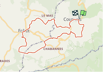
11.1 km | 14.2 km-effort
3h 6min
Yes
Trail On foot Saint-Saturnin - Randol - Photo
On foot
GUIDE+

On foot

Easy
(1)
Saint-Saturnin, Auvergne-Rhône-Alpes, Puy-de-Dôme, France
7.8 km | 10.6 km-effort
2h 24min
Yes
Trail On foot Saint-Saturnin - Les Cirques de longevette et des Cotes - Photo
On foot
GUIDE+

On foot

Easy
Saint-Saturnin, Auvergne-Rhône-Alpes, Puy-de-Dôme, France
5.4 km | 7.1 km-effort
1h 37min
Yes
Trail On foot Aydat - Les Cheires Hautes - Photo
On foot
GUIDE+

On foot

Easy
Aydat, Auvergne-Rhône-Alpes, Puy-de-Dôme, France
15.9 km | 20 km-effort
4h 32min
Yes
Trail On foot Aydat - Le Lac de la Cassière - Photo
On foot
GUIDE+

On foot

Easy
Aydat, Auvergne-Rhône-Alpes, Puy-de-Dôme, France
3.2 km | 4 km-effort
54min
Yes
Trail On foot Saint-Genès-Champanelle - Nadaillat - Photo
On foot
GUIDE+

On foot

Easy
Saint-Genès-Champanelle, Auvergne-Rhône-Alpes, Puy-de-Dôme, France
6.6 km | 9.3 km-effort
2h 7min
Yes
Trail On foot Chanonat - Le Crest - Photo
On foot
GUIDE+

On foot

Easy
Chanonat, Auvergne-Rhône-Alpes, Puy-de-Dôme, France
10.7 km | 14.7 km-effort
3h 20min
Yes
Trail Walking Saint-Saturnin - St saturnin - Photo
Walking
guy63

Walking

Very easy
(1)
Saint-Saturnin, Auvergne-Rhône-Alpes, Puy-de-Dôme, France
15.7 km | 21 km-effort
4h 29min
Yes
Trail Walking Aydat - Fohet_Landes - Photo
Walking
GUIDE
jagarnier

Walking

Medium
(1)
Aydat, Auvergne-Rhône-Alpes, Puy-de-Dôme, France
13.1 km | 16.8 km-effort
4h 0min
Yes


Close
My subscriptions