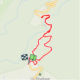
![](/images/other/stat-length.png)
![Trail Walking Les Avirons - Sentier des ouvriers 20190224 - Photo](https://media.geolcdn.com/t/1900/400/869a0788-b6f9-4f1f-8850-e496527cea81.jpg&format=pjpeg&maxdim=2)
Sentier des ouvriers 20190224
YCDBSOYA
User
![Length](/images/other/stat-length.png)
![Max alt](https://static1.geolcdn.com/siteimages/upload/files/1508320355ic_sort_altitude_max_24dp.png)
![Uphill gradient](https://static1.geolcdn.com/siteimages/upload/files/1508320355ic_sort_den_pos_24dp.png)
![Km-Effort](/images/other/stat-length.png)
![Min alt](https://static1.geolcdn.com/siteimages/upload/files/1508320355ic_sort_altitude_min_24dp.png)
![Downhill gradient](https://static1.geolcdn.com/siteimages/upload/files/1508320355ic_sort_den_neg_24dp.png)
![Boucle](https://static1.geolcdn.com/siteimages/upload/files/16400158638029165_repeat_loop_refresh_sync_direction_icon.png)
![Walking](https://static1.geolcdn.com/sitytour/trail-icons/101.png)
1h29
Difficulty : Easy
![Scan this QR Code to open this trail in the SityTrail application](https://capi.geolives.com/qq0zvz2zws4bq2lad0pu/sitytour/trails/2038815/qr.png?size=200)
FREE GPS app for hiking
About
Trail Walking of 2.9 km to be discovered at Réunion, Unknown, Les Avirons. This trail is proposed by YCDBSOYA.
Description
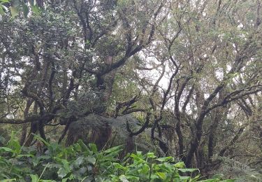
Rando agréable au milieu de la Forêt du Tevelave.
Toutefois, pendant la saison des pluies les portions de sentier, entre deux reprise de la route forestière du Tevelave sont un peu glissantes.
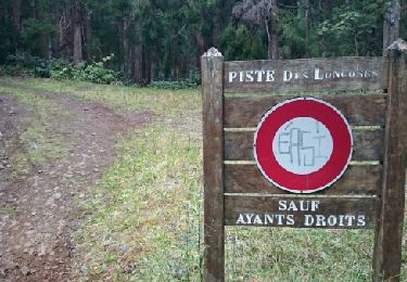
Sur le retour, par la route forestière, on peut rencontrer quelques éboulis de terre à passer, justifiant que cette route est barrée dès le point de départ de la Rando.
Sur le parcours on rencontre de nombreux endroits agrémentés de Fougères arborescentes et des Longoses, soit isolées soit en massifs.
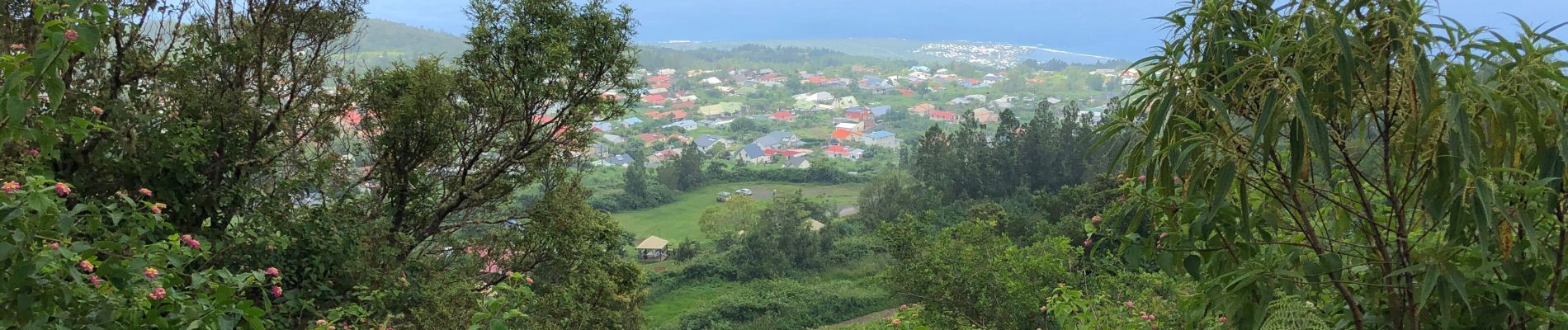
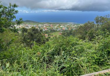
Quelques points de vue sur le littoral sur le premier tronçon de sentier.
Positioning
Comments
Trails nearby
![Trail Walking Les Avirons - La Réunion - Boucle au Tevelave par le Sentier Grande Terre - Photo](https://media.geolcdn.com/t/375/260/ext.jpg?maxdim=2&url=https%3A%2F%2Fservices.sitytrail.com%2FGeolivesWS%2FDownloadMedia.ashx%3FTrailID%3D447253%26Media%3Dfix__20150719113959.jpg)
![Walking Walking](https://static1.geolcdn.com/sitytour/trail-icons/101.png)
Walking
![](/images/other/stat-length.png)
![](https://static1.geolcdn.com/siteimages/upload/files/16400158638029165_repeat_loop_refresh_sync_direction_icon.png)
![Trail Walking Les Avirons - Sur la route forestière de Tévelave - Photo](https://media.geolcdn.com/t/375/260/109dccb4-07aa-4f7e-9cbd-0938a0d048ec.jpg&format=jpg&maxdim=2)
![Walking Walking](https://static1.geolcdn.com/sitytour/trail-icons/101.png)
Walking
![](/images/other/stat-length.png)
![](https://static1.geolcdn.com/siteimages/upload/files/16400158638029165_repeat_loop_refresh_sync_direction_icon.png)
![Trail Walking Saint-Leu - St Leu Le Cap Camélia - Photo](https://media.geolcdn.com/t/375/260/92ca7314-1976-4004-ae23-9dc4d05c4cc2.jpg&format=jpg&maxdim=2)
![Walking Walking](https://static1.geolcdn.com/sitytour/trail-icons/101.png)
Walking
![](/images/other/stat-length.png)
![](https://static1.geolcdn.com/siteimages/upload/files/16400158638029165_repeat_loop_refresh_sync_direction_icon.png)
![Trail Walking Les Avirons - sentier des ouvriers - Photo](https://media.geolcdn.com/t/375/260/c581b641-d6b2-425a-875b-a73ca70de4af.jpg&format=jpg&maxdim=2)
![Walking Walking](https://static1.geolcdn.com/sitytour/trail-icons/101.png)
Walking
![](/images/other/stat-length.png)
![](https://static1.geolcdn.com/siteimages/upload/files/16400158638029165_repeat_loop_refresh_sync_direction_icon.png)
![Trail Walking Les Avirons - La Réunion - Observatoire des Papangues - Photo](https://media.geolcdn.com/t/375/260/ext.jpg?maxdim=2&url=https%3A%2F%2Fservices.sitytrail.com%2FGeolivesWS%2FDownloadMedia.ashx%3FTrailID%3D447254%26Media%3De84d0fc0-7cd0-4b5e-a43f-300302b83197.jpg)
![Walking Walking](https://static1.geolcdn.com/sitytour/trail-icons/101.png)
Walking
![](/images/other/stat-length.png)
![](https://static1.geolcdn.com/siteimages/upload/files/16400158638029165_repeat_loop_refresh_sync_direction_icon.png)
![Trail Walking Les Avirons - boucle Avirons ch molina,queue de cheval, ravine seche - Photo](https://media.geolcdn.com/t/375/260/ext.jpg?maxdim=2&url=https%3A%2F%2Fstatic1.geolcdn.com%2Fsiteimages%2Fupload%2Ffiles%2F1553511878bg_sport_marche.png)
![Walking Walking](https://static1.geolcdn.com/sitytour/trail-icons/101.png)
Walking
![](/images/other/stat-length.png)
![](https://static1.geolcdn.com/siteimages/upload/files/16400158638029165_repeat_loop_refresh_sync_direction_icon.png)
![Trail Car Saint-Leu - Culais - Photo](https://media.geolcdn.com/t/375/260/ext.jpg?maxdim=2&url=https%3A%2F%2Fstatic1.geolcdn.com%2Fsiteimages%2Fupload%2Ffiles%2F15247431544x4.jpg)
![Car Car](https://static1.geolcdn.com/sitytour/trail-icons/401.png)
![Trail Walking Les Avirons - Sentier des tamarins, vue sur les Makes - Photo](https://media.geolcdn.com/t/375/260/ext.jpg?maxdim=2&url=https%3A%2F%2Fstatic1.geolcdn.com%2Fsiteimages%2Fupload%2Ffiles%2F1553511878bg_sport_marche.png)
![Walking Walking](https://static1.geolcdn.com/sitytour/trail-icons/101.png)
Walking
![](/images/other/stat-length.png)
![](https://static1.geolcdn.com/siteimages/upload/files/16400158638029165_repeat_loop_refresh_sync_direction_icon.png)
![Trail Walking L'Étang-Salé - Le piton de la croix - Photo](https://media.geolcdn.com/t/375/260/ext.jpg?maxdim=2&url=https%3A%2F%2Fstatic1.geolcdn.com%2Fsiteimages%2Fupload%2Ffiles%2F1553511878bg_sport_marche.png)
![Walking Walking](https://static1.geolcdn.com/sitytour/trail-icons/101.png)
Walking
![](/images/other/stat-length.png)
![](https://static1.geolcdn.com/siteimages/upload/files/16400158638029165_repeat_loop_refresh_sync_direction_icon.png)