Trail Walking Orcières - 09072013retour - Photo
© OpenStreetMap contributors
Length
Length
6.8 km
Max alt
Max alt
1889 m
Uphill gradient
Uphill gradient
54 m
Km-Effort
Km-Effort  
8.7 km
Min alt
Min alt
1533 m
Downhill gradient
Downhill gradient
405 m
Boucle
Boucle
No
Creation date :
2014-12-10 00:00:00.0
Updated on :
2014-12-10 00:00:00.0

(1 Reviews)

Walking
Walking
2h04
Difficulty : Easy

Scan this QR Code to open this trail in the SityTrail application

FREE GPS app for hiking

Logo SityTrail SityTrail

IGN / Geographical institutes

Download SityTrail from the App Store Download SityTrail from Google Play

Logo SityTrail SityTrail World

The world is yours!

Download SityTrail from the App Store Download SityTrail from Google Play Download SityTrail on Huawei AppGallery

About

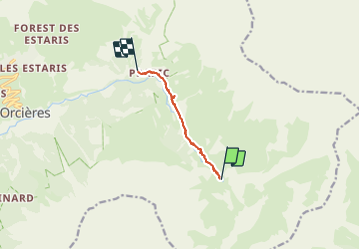
Trail Walking of 6.8 km to be discovered at Provence-Alpes-Côte d'Azur, Hautes-Alpes, Orcières. This trail is proposed by mikaelerouzic.

Elevation profile

Photos

Positioning

Country:
France
Region :
Provence-Alpes-Côte d'Azur
Department/Province :
Hautes-Alpes
Municipality :
Orcières
Location:
Unknown
Start:(UTM)
293453 ; 4949276 (32T) N.

Comments

Please log in to post a review or rate the element


bien mais pert le lien vers la carte ext..... je dois reparametrer !


Trails nearby

Trail Walking Orcières - R45   Marmottes a Prapic - Photo
Walking
GUIDE+

Walking

Medium
(2)
Orcières, Provence-Alpes-Côte d'Azur, Hautes-Alpes, France
9 km | 14 km-effort
2h 57min
Yes
Trail Walking Orcières - Orcieres (Hautes Alpes) - Photo
Walking
ISATR

Walking

Very difficult
(1)
Orcières, Provence-Alpes-Côte d'Azur, Hautes-Alpes, France
12 km | 19.4 km-effort
4h 24min
Yes
Trail Touring skiing Orcières - L'homme de Prapic  - Photo
Touring skiing
GUIDE
nadd73

Touring skiing

Medium
Orcières, Provence-Alpes-Côte d'Azur, Hautes-Alpes, France
15.8 km | 33 km-effort
4h 34min
Yes
Trail Walking Orcières - Saut du Laire - Photo
Walking
GUIDE
Marco05

Walking

Medium
Orcières, Provence-Alpes-Côte d'Azur, Hautes-Alpes, France
11.4 km | 18.9 km-effort
4h 17min
Yes
Trail Walking Orcières - Lac des Pisses - Photo
Walking
GUIDE
Marco05

Walking

Difficult
Orcières, Provence-Alpes-Côte d'Azur, Hautes-Alpes, France
13.2 km | 26 km-effort
5h 58min
Yes
Trail Touring skiing Orcières - objectif Rocher blanc mais trop long donc direction chapeau rouge - Photo
Touring skiing
GUIDE
nadd73

Touring skiing

Medium
Orcières, Provence-Alpes-Côte d'Azur, Hautes-Alpes, France
17.2 km | 32 km-effort
6h 0min
Yes
Trail Touring skiing Orcières - Le chapeau rouge - Photo
Touring skiing
GUIDE
nadd73

Touring skiing

Medium
Orcières, Provence-Alpes-Côte d'Azur, Hautes-Alpes, France
16 km | 31 km-effort
5h 54min
Yes
Trail Walking Orcières - Col des Tourettes - Croix Lorraine 08/09/18 - Photo
Walking
GUIDE
R@ph

Walking

Difficult
Orcières, Provence-Alpes-Côte d'Azur, Hautes-Alpes, France
21 km | 37 km-effort
5h 30min
Yes
Trail Walking Châteauroux-les-Alpes - Mourre Froid 01/09/18 - Photo
Walking
GUIDE
R@ph

Walking

Very difficult
Châteauroux-les-Alpes, Provence-Alpes-Côte d'Azur, Hautes-Alpes, France
16 km | 35 km-effort
6h 51min
Yes


Close
My subscriptions