Trail On foot Uffholtz - Col de Herrenfluh - Molkenrain - Chapelle du Freundstein - Abri Becherkopf et retour - Photo

Col de Herrenfluh - Molkenrain - Chapelle du Freundstein - Abri Becherkopf et retour

© OpenStreetMap contributors
Length
Length
11.1 km
Max alt
Max alt
1088 m
Uphill gradient
Uphill gradient
409 m
Km-Effort
Km-Effort  
16.6 km
Min alt
Min alt
812 m
Downhill gradient
Downhill gradient
416 m
Boucle
Boucle
Yes
Creation date :
2019-02-22 08:28:28.402
Updated on :
2019-02-22 08:52:29.685

(1 Reviews)

On foot
On foot
--
Difficulty : Medium

Scan this QR Code to open this trail in the SityTrail application

FREE GPS app for hiking

Logo SityTrail SityTrail

IGN / Geographical institutes

Download SityTrail from the App Store Download SityTrail from Google Play

Logo SityTrail SityTrail World

The world is yours!

Download SityTrail from the App Store Download SityTrail from Google Play Download SityTrail on Huawei AppGallery

About

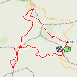
Trail On foot of 11.1 km to be discovered at Grand Est, Haut-Rhin, Uffholtz. This trail is proposed by patrickbeyrath.

Elevation profile

Positioning

Country:
France
Region :
Grand Est
Department/Province :
Haut-Rhin
Municipality :
Uffholtz
Location:
Unknown
Start:(UTM)
361067 ; 5300802 (32T) N.

Comments

Please log in to post a review or rate the element


Belle rando, avec une belle montée au début et une suite tranquille à partir de la FA du Molkenrain.


Trails nearby

Trail Walking Soultz-Haut-Rhin - Hartmannswillerkopf - Circuit découverte - Photo
Walking
VacheKiri67

Walking

Easy
(1)
Soultz-Haut-Rhin, Grand Est, Haut-Rhin, France
3.6 km | 5.2 km-effort
1h 46min
Yes
Trail Walking Soultz-Haut-Rhin - Hartmannswillerkopf - Circuit anneau bleu - Photo
Walking
VacheKiri67

Walking

Medium
(1)
Soultz-Haut-Rhin, Grand Est, Haut-Rhin, France
3.7 km | 5.9 km-effort
1h 37min
Yes
Trail Other activity Steinbach - lac du ballon - Photo
Other activity
rodabruna

Other activity

Very easy
(1)
Steinbach, Grand Est, Haut-Rhin, France
33 km | 64 km-effort
5h 1min
No
Trail Road bike Cernay - Le Grand ballon de Cernay  - Photo
Road bike
GUIDE
nadd73

Road bike

Difficult
Cernay, Grand Est, Haut-Rhin, France
23 km | 36 km-effort
2h 15min
No
Trail On foot Goldbach-Altenbach - Firstacker - Willer sur Thur - Photo
On foot
GUIDE+

On foot

Easy
Goldbach-Altenbach, Grand Est, Haut-Rhin, France
7.4 km | 9.6 km-effort
2h 11min
No
Trail Trail Wattwiller - The History Ultra - stage 1 - Photo
Trail
Olivier Houette

Trail

Very easy
(1)
Wattwiller, Grand Est, Haut-Rhin, France
28 km | 48 km-effort
Unknown
No
Trail Walking Thann - SityTrail - 2489713 - thann-roche--albert--grumbachkopf - Photo
Walking
argonneuweg

Walking

Medium
(1)
Thann, Grand Est, Haut-Rhin, France
7.6 km | 12 km-effort
2h 28min
Yes
Trail On foot Bitschwiller-lès-Thann - Bitschwiller les Thann - Rehbrunnel - Abri du Becherkopf - Roche Albert - Photo
On foot
patrickbeyrath

On foot

Medium
(1)
Bitschwiller-lès-Thann, Grand Est, Haut-Rhin, France
10.3 km | 16.4 km-effort
Unknown
Yes
Trail Walking Uffholtz - Molkenrain 1 - Photo
Walking
regisbodilis

Walking

Difficult
(1)
Uffholtz, Grand Est, Haut-Rhin, France
15.4 km | 26 km-effort
4h 0min
Yes


Close
My subscriptions