Trail Running Sendim e Atenor - trek/Trail vers le Douro - Photo
 vitor999
vitor999

User

© OpenStreetMap contributors
Length
Length
5 km
Max alt
Max alt
716 m
Uphill gradient
Uphill gradient
22 m
Km-Effort
Km-Effort  
6.2 km
Min alt
Min alt
417 m
Downhill gradient
Downhill gradient
307 m
Boucle
Boucle
No
Creation date :
2014-12-10 00:00:00.0
Updated on :
2014-12-10 00:00:00.0

(0 Reviews)

Running
Running
1h20
Difficulty : Difficult

Scan this QR Code to open this trail in the SityTrail application

FREE GPS app for hiking

Logo SityTrail SityTrail

IGN / Geographical institutes

Download SityTrail from the App Store Download SityTrail from Google Play

Logo SityTrail SityTrail World

The world is yours!

Download SityTrail from the App Store Download SityTrail from Google Play Download SityTrail on Huawei AppGallery

About

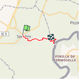
Trail Running of 5 km to be discovered at North, Bragança District, Sendim e Atenor. This trail is proposed by vitor999.

Description

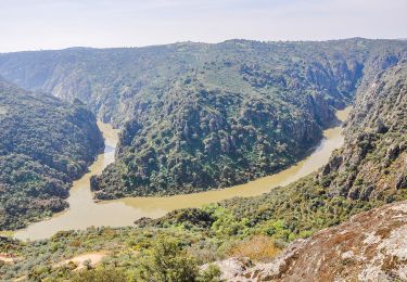
De la ville de Sendim vers le Douro (Frontière Espagnole)

Elevation profile

Positioning

Country:
Portugal
Region :
North
Department/Province :
Bragança District
Municipality :
Sendim e Atenor
Location:
Sendim
Start:(UTM)
715039 ; 4585329 (29T) N.

Trails nearby

Trail On foot Picote - Picote - Fonte de Aldeia - Picote - Photo
On foot
PRO

On foot

Easy
Picote, North, Bragança District, Portugal
9.1 km | 10.4 km-effort
2h 22min
No
Trail On foot Picote - Picote - Eiras - Picote _ Camino de ls molinos - Auga - Photo
On foot
PRO

On foot

Easy
Picote, North, Bragança District, Portugal
6.5 km | 8 km-effort
1h 49min
Yes
Trail On foot Picote - Picote - Santos - Picote _ Camino de ls Santos - Fuogo - Photo
On foot
PRO

On foot

Easy
Picote, North, Bragança District, Portugal
7.2 km | 10.2 km-effort
2h 19min
No
Trail Walking Villar del Buey - Pina de Fermoselle  - Photo
Walking
taguette

Walking

Very difficult
Villar del Buey, Castile and León, Unknown, Spain
19.5 km | 26 km-effort
5h 42min
Yes


Close
My subscriptions