![](/images/other/stat-length.png)
![Trail Nordic walking Lodève - Grézac et dolmen - Photo](https://media.geolcdn.com/t/1900/400/f2baea80-070a-450b-a7e8-5b8fa1a09e72.jpg&format=pjpeg&maxdim=2)
Grézac et dolmen
mdauzat
User
![Length](/images/other/stat-length.png)
Length
10.6 km
![Max alt](https://static1.geolcdn.com/siteimages/upload/files/1508320355ic_sort_altitude_max_24dp.png)
Max alt
644 m
![Uphill gradient](https://static1.geolcdn.com/siteimages/upload/files/1508320355ic_sort_den_pos_24dp.png)
Uphill gradient
392 m
![Km-Effort](/images/other/stat-length.png)
Km-Effort
15.8 km
![Min alt](https://static1.geolcdn.com/siteimages/upload/files/1508320355ic_sort_altitude_min_24dp.png)
Min alt
269 m
![Downhill gradient](https://static1.geolcdn.com/siteimages/upload/files/1508320355ic_sort_den_neg_24dp.png)
Downhill gradient
390 m
![Boucle](https://static1.geolcdn.com/siteimages/upload/files/16400158638029165_repeat_loop_refresh_sync_direction_icon.png)
Boucle
Yes
Creation date :
2019-02-13 14:27:45.841
Updated on :
2023-11-12 14:21:42.342
![Nordic walking](https://static1.geolcdn.com/sitytour/trail-icons/102.png)
2h49
Difficulty : Easy
![Scan this QR Code to open this trail in the SityTrail application](https://capi.geolives.com/qq0zvz2zws4bq2lad0pu/sitytour/trails/2034658/qr.png?size=200)
FREE GPS app for hiking
About
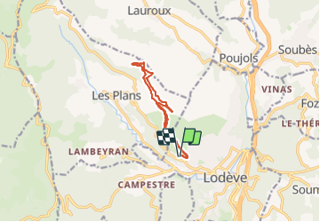
Trail Nordic walking of 10.6 km to be discovered at Occitania, Hérault, Lodève. This trail is proposed by mdauzat.
Description
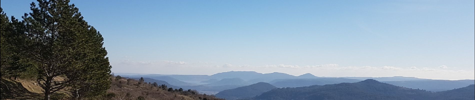
Belle marche sur le sentier du Livre du Lodévois puis sur large piste forestières, avec très belles vues sur la vallée, montant vers le col du Perthus, puis sur le lac du Salagou, avec un court détour vers un très beau petit dolmen avec vue imprenable.
Positioning
Country:
France
Region :
Occitania
Department/Province :
Hérault
Municipality :
Lodève
Location:
Unknown
Start:(Dec)
Start:(UTM)
524292 ; 4842676 (31T) N.
Comments
Trails nearby
![Trail Nordic walking Olmet-et-Villecun - Villecun Lavalette - Photo](https://media.geolcdn.com/t/375/260/ff5dbcc8-7f6e-486e-b563-291aeb3db524.jpg&format=jpg&maxdim=2)
![Nordic walking Nordic walking](https://static1.geolcdn.com/sitytour/trail-icons/102.png)
Villecun Lavalette
Nordic walking
Easy
(1)
Olmet-et-Villecun,
Occitania,
Hérault,
France
![](/images/other/stat-length.png)
9.3 km | 12.4 km-effort
2h 13min
![](https://static1.geolcdn.com/siteimages/upload/files/16400158638029165_repeat_loop_refresh_sync_direction_icon.png)
Yes
![Trail Nordic walking Lodève - Chemin des Tines - La Défriche - Belbezet - Montifort - Photo](https://media.geolcdn.com/t/375/260/5db620f0-9bce-46db-b4f7-036de46feabc.jpg&format=jpg&maxdim=2)
![Nordic walking Nordic walking](https://static1.geolcdn.com/sitytour/trail-icons/102.png)
Chemin des Tines - La Défriche - Belbezet - Montifort
Nordic walking
Easy
(1)
Lodève,
Occitania,
Hérault,
France
![](/images/other/stat-length.png)
8.3 km | 11.9 km-effort
Unknown
![](https://static1.geolcdn.com/siteimages/upload/files/16400158638029165_repeat_loop_refresh_sync_direction_icon.png)
Yes
![Trail Walking Les Plans - Forêt domaniale d'Escandorgue par Roqueredonde et l'Engayresque - Photo](https://media.geolcdn.com/t/375/260/c203cd03-9ac1-4e05-8a4c-6b4e6f9317be.jpg&format=jpg&maxdim=2)
![Walking Walking](https://static1.geolcdn.com/sitytour/trail-icons/101.png)
Forêt domaniale d'Escandorgue par Roqueredonde et l'Engayresque
Walking
Medium
(1)
Les Plans,
Occitania,
Hérault,
France
![](/images/other/stat-length.png)
14.2 km | 19.7 km-effort
5h 2min
![](https://static1.geolcdn.com/siteimages/upload/files/16400158638029165_repeat_loop_refresh_sync_direction_icon.png)
Yes
![Walking Walking](https://static1.geolcdn.com/sitytour/trail-icons/101.png)
Grézac Pierre plate
Walking
Medium
(1)
Lodève,
Occitania,
Hérault,
France
![](/images/other/stat-length.png)
8.8 km | 13.2 km-effort
2h 44min
![](https://static1.geolcdn.com/siteimages/upload/files/16400158638029165_repeat_loop_refresh_sync_direction_icon.png)
Yes
![Trail Walking Lodève - Saint-Martin - L'Ambeyran - Photo](https://media.geolcdn.com/t/375/260/ef8a520f-2d1e-48a3-a95d-ed76e0089665.jpg&format=jpg&maxdim=2)
![Walking Walking](https://static1.geolcdn.com/sitytour/trail-icons/101.png)
Saint-Martin - L'Ambeyran
Walking
Medium
(1)
Lodève,
Occitania,
Hérault,
France
![](/images/other/stat-length.png)
9.4 km | 12.8 km-effort
2h 2min
![](https://static1.geolcdn.com/siteimages/upload/files/16400158638029165_repeat_loop_refresh_sync_direction_icon.png)
Yes
![Trail Walking Soumont - Balcons de Soumont - Photo](https://media.geolcdn.com/t/375/260/d9f45190-3768-4750-9561-de3d1f0991af.jpg&format=jpg&maxdim=2)
![Walking Walking](https://static1.geolcdn.com/sitytour/trail-icons/101.png)
Balcons de Soumont
Walking
Medium
(1)
Soumont,
Occitania,
Hérault,
France
![](/images/other/stat-length.png)
8.4 km | 11.9 km-effort
2h 29min
![](https://static1.geolcdn.com/siteimages/upload/files/16400158638029165_repeat_loop_refresh_sync_direction_icon.png)
Yes
![Trail Walking Lauroux - les corniches de lauroux - Photo](https://media.geolcdn.com/t/375/260/ext.jpg?maxdim=2&url=https%3A%2F%2Fservices.sitytrail.com%2FGeolivesWS%2FDownloadMedia.ashx%3FTrailID%3D333456%26Media%3D20140811173610.jpg)
![Walking Walking](https://static1.geolcdn.com/sitytour/trail-icons/101.png)
les corniches de lauroux
Walking
Difficult
(1)
Lauroux,
Occitania,
Hérault,
France
![](/images/other/stat-length.png)
15.5 km | 24 km-effort
5h 4min
![](https://static1.geolcdn.com/siteimages/upload/files/16400158638029165_repeat_loop_refresh_sync_direction_icon.png)
Yes
![Trail Walking Lodève - Le plateau de Grezac au depart de Lodève - Photo](https://media.geolcdn.com/t/375/260/ext.jpg?maxdim=2&url=https%3A%2F%2Fservices.sitytrail.com%2FGeolivesWS%2FDownloadMedia.ashx%3FTrailID%3D272866%26Media%3Dfix__20140430102722.jpg)
![Walking Walking](https://static1.geolcdn.com/sitytour/trail-icons/101.png)
Le plateau de Grezac au depart de Lodève
Walking
Medium
(1)
Lodève,
Occitania,
Hérault,
France
![](/images/other/stat-length.png)
15.8 km | 23 km-effort
6h 20min
![](https://static1.geolcdn.com/siteimages/upload/files/16400158638029165_repeat_loop_refresh_sync_direction_icon.png)
Yes
![Trail Walking Soumont - Soumont et ses Dolmens - Photo](https://media.geolcdn.com/t/375/260/ext.jpg?maxdim=2&url=https%3A%2F%2Fservices.sitytrail.com%2FGeolivesWS%2FDownloadMedia.ashx%3FTrailID%3D198665%26Media%3D20130616160313.jpg)
![Walking Walking](https://static1.geolcdn.com/sitytour/trail-icons/101.png)
Soumont et ses Dolmens
Walking
Medium
(3)
Soumont,
Occitania,
Hérault,
France
![](/images/other/stat-length.png)
18.2 km | 26 km-effort
5h 56min
![](https://static1.geolcdn.com/siteimages/upload/files/16400158638029165_repeat_loop_refresh_sync_direction_icon.png)
Yes