Trail Walking Châteauvillain - chateauvillain - Photo
 gimbretb
gimbretb

User

© OpenStreetMap contributors
Length
Length
11.9 km
Max alt
Max alt
301 m
Uphill gradient
Uphill gradient
132 m
Km-Effort
Km-Effort  
13.7 km
Min alt
Min alt
228 m
Downhill gradient
Downhill gradient
133 m
Boucle
Boucle
Yes
Creation date :
2019-02-06 14:04:07.898
Updated on :
2019-02-06 16:56:35.674

(0 Reviews)

Walking
Walking
2h51
Difficulty : Very easy

Scan this QR Code to open this trail in the SityTrail application

FREE GPS app for hiking

Logo SityTrail SityTrail

IGN / Geographical institutes

Download SityTrail from the App Store Download SityTrail from Google Play

Logo SityTrail SityTrail World

The world is yours!

Download SityTrail from the App Store Download SityTrail from Google Play Download SityTrail on Huawei AppGallery

About

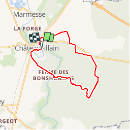
Trail Walking of 11.9 km to be discovered at Grand Est, Haute-Marne, Châteauvillain. This trail is proposed by gimbretb.

Description

départ parking parc aux daims

Elevation profile

Positioning

Country:
France
Region :
Grand Est
Department/Province :
Haute-Marne
Municipality :
Châteauvillain
Location:
Châteauvillain
Start:(UTM)
643224 ; 5322073 (31U) N.

Trails nearby

Trail Mountain bike Orges - Orges-Foret Chateauvillain-Blessonville - Photo
Mountain bike
PhilAux

Mountain bike

Medium
(1)
Orges, Grand Est, Haute-Marne, France
26 km | 29 km-effort
2h 10min
Yes
Trail Mountain bike Orges - Orges - Forêt chateauvillain - Val Mormand - Photo
Mountain bike
PhilAux

Mountain bike

Very difficult
(1)
Orges, Grand Est, Haute-Marne, France
25 km | 29 km-effort
3h 4min
Yes
Trail Walking Châteauvillain - Créancey. Marche à travers champs et forêts  - Photo
Walking
wallander76

Walking

Medium
Châteauvillain, Grand Est, Haute-Marne, France
15.7 km | 20 km-effort
2h 52min
Yes
Trail Mountain bike Châteauvillain - La Via Francigena - Traversée de la Haute Marne -de Châteauvillain à Mormant - Photo
Mountain bike
tracegps

Mountain bike

Medium
Châteauvillain, Grand Est, Haute-Marne, France
23 km | 27 km-effort
2h 0min
No
Trail Walking Châteauvillain - La Via Francigena - Traversée de la Haute Marne -de Châteauvillain à Mormant - Photo
Walking
tracegps

Walking

Medium
Châteauvillain, Grand Est, Haute-Marne, France
23 km | 27 km-effort
4h 30min
No
Trail Other activity Bricon - bricon 52 - Photo
Other activity
gimbretb

Other activity

Easy
Bricon, Grand Est, Haute-Marne, France
26 km | 32 km-effort
6h 18min
Yes
Trail Walking Châteauvillain - Chateuvillain - Photo
Walking
irenep52

Walking

Medium
Châteauvillain, Grand Est, Haute-Marne, France
7.5 km | 8.7 km-effort
1h 58min
Yes
Trail Walking Orges - kkk - Photo
Walking
ThierryDivay

Walking

Very easy
Orges, Grand Est, Haute-Marne, France
20 km | 24 km-effort
5h 33min
No
Trail Walking Orges - Orges  Circuit du Muguet - Photo
Walking
irenep52

Walking

Medium
Orges, Grand Est, Haute-Marne, France
9.4 km | 11.6 km-effort
2h 37min
Yes


Close
My subscriptions