Trail Camping car Cavaillon - camping car 2bis le tour du luberon - Photo

camping car 2bis le tour du luberon

© OpenStreetMap contributors
Length
Length
249 km
Max alt
Max alt
697 m
Uphill gradient
Uphill gradient
3533 m
Km-Effort
Km-Effort  
296 km
Min alt
Min alt
57 m
Downhill gradient
Downhill gradient
3535 m
Boucle
Boucle
Yes
Creation date :
2019-01-31 12:36:44.757
Updated on :
2019-01-31 18:04:04.575

(0 Reviews)

Camping car
Camping car
--
Difficulty : Very easy

Scan this QR Code to open this trail in the SityTrail application

FREE GPS app for hiking

Logo SityTrail SityTrail

IGN / Geographical institutes

Download SityTrail from the App Store Download SityTrail from Google Play

Logo SityTrail SityTrail World

The world is yours!

Download SityTrail from the App Store Download SityTrail from Google Play Download SityTrail on Huawei AppGallery

About

Trail Camping car of 249 km to be discovered at Provence-Alpes-Côte d'Azur, Vaucluse, Cavaillon. This trail is proposed by loursblanc.

Description

site weeb campingcarsite
le tour du luberon
perle de provence

Elevation profile

Positioning

Country:
France
Region :
Provence-Alpes-Côte d'Azur
Department/Province :
Vaucluse
Municipality :
Cavaillon
Location:
Unknown
Start:(UTM)
663837 ; 4854026 (31T) N.

Trails nearby

Trail Cycle Cavaillon - Autour du Luberon à vélo - Photo
Cycle
GUIDE+

Cycle

Difficult
(4)
Cavaillon, Provence-Alpes-Côte d'Azur, Vaucluse, France
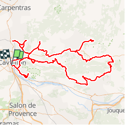
236 km | 285 km-effort
15h 46min
Yes
Trail Cycle Cavaillon - Parcours n°3 - Cavaillon - Photo
Cycle
GUIDE+

Cycle

Easy
(2)
Cavaillon, Provence-Alpes-Côte d'Azur, Vaucluse, France
45 km | 50 km-effort
2h 55min
No
Trail Cycle Cavaillon - Parcours n°1 - Cavaillon - Photo
Cycle
GUIDE+

Cycle

Difficult
(2)
Cavaillon, Provence-Alpes-Côte d'Azur, Vaucluse, France
33 km | 41 km-effort
2h 21min
Yes
Trail Walking Orgon - plan Orgon di19mai2013 - Photo
Walking
tvtv84

Walking

Easy
(2)
Orgon, Provence-Alpes-Côte d'Azur, Bouches-du-Rhône, France
16 km | 18.8 km-effort
4h 28min
Yes
Trail Walking Taillades - Par la Gorge de Badarel et les Rochers de Baude - Photo
Walking
tracegps

Walking

Medium
(3)
Taillades, Provence-Alpes-Côte d'Azur, Vaucluse, France
8 km | 14.7 km-effort
4h 0min
Yes
Trail Walking Taillades - Les Taillades-De la source du Boulon au Castelas - Gorge de Badarel sous la neige - Photo
Walking
tracegps

Walking

Difficult
(1)
Taillades, Provence-Alpes-Côte d'Azur, Vaucluse, France
7 km | 10.8 km-effort
3h 0min
Yes
Trail Walking Orgon - Orgon-vallée heureuse - Photo
Walking
Berpav

Walking

Difficult
(1)
Orgon, Provence-Alpes-Côte d'Azur, Bouches-du-Rhône, France
10.7 km | 13.4 km-effort
2h 27min
Yes
Trail Walking Taillades - Taillades Badarel  Brayette Robion - Photo
Walking
kephas

Walking

Difficult
(1)
Taillades, Provence-Alpes-Côte d'Azur, Vaucluse, France
10.6 km | 17.6 km-effort
3h 41min
Yes
Trail Walking Cheval-Blanc - bergerie/badarel - Photo
Walking
fireman84

Walking

Medium
(1)
Cheval-Blanc, Provence-Alpes-Côte d'Azur, Vaucluse, France
9.9 km | 16 km-effort
3h 20min
Yes


Close
My subscriptions