![](/images/other/stat-length.png)
![Trail Walking Clamart - Meudon la forêt - Photo](https://media.geolcdn.com/t/1900/400/9537a14c-beac-4b70-bb40-074c4795d48c.jpg&format=pjpeg&maxdim=2)
Meudon la forêt
c.chehere
User
![Length](/images/other/stat-length.png)
Length
17.9 km
![Max alt](https://static1.geolcdn.com/siteimages/upload/files/1508320355ic_sort_altitude_max_24dp.png)
Max alt
187 m
![Uphill gradient](https://static1.geolcdn.com/siteimages/upload/files/1508320355ic_sort_den_pos_24dp.png)
Uphill gradient
361 m
![Km-Effort](/images/other/stat-length.png)
Km-Effort
23 km
![Min alt](https://static1.geolcdn.com/siteimages/upload/files/1508320355ic_sort_altitude_min_24dp.png)
Min alt
110 m
![Downhill gradient](https://static1.geolcdn.com/siteimages/upload/files/1508320355ic_sort_den_neg_24dp.png)
Downhill gradient
362 m
![Boucle](https://static1.geolcdn.com/siteimages/upload/files/16400158638029165_repeat_loop_refresh_sync_direction_icon.png)
Boucle
Yes
Creation date :
2019-01-29 09:10:59.048
Updated on :
2019-01-29 15:46:37.356
![Walking](https://static1.geolcdn.com/sitytour/trail-icons/101.png)
5h03
Difficulty : Medium
![Scan this QR Code to open this trail in the SityTrail application](https://capi.geolives.com/qq0zvz2zws4bq2lad0pu/sitytour/trails/2029983/qr.png?size=200)
FREE GPS app for hiking
About
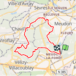
Trail Walking of 17.9 km to be discovered at Ile-de-France, Hauts-de-Seine, Clamart. This trail is proposed by c.chehere.
Description
Parking dans le haut du tapis vert.
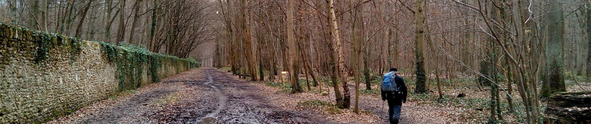
Rando surprise sans préparation pour remplacement d'un itinéraire en forêt de Sénart, mais alerte neige.
Déjeuner au doisus
Positioning
Country:
France
Region :
Ile-de-France
Department/Province :
Hauts-de-Seine
Municipality :
Clamart
Location:
Unknown
Start:(Dec)
Start:(UTM)
443933 ; 5404304 (31U) N.
Comments
Trails nearby
![Trail Walking Chaville - Le Sentier des 7 étangs - Photo](https://media.geolcdn.com/t/375/260/ext.jpg?maxdim=2&url=https%3A%2F%2Fservices.sitytrail.com%2FGeolivesWS%2FDownloadMedia.ashx%3FTrailID%3D110203%26Media%3D5435_1.jpg)
![Walking Walking](https://static1.geolcdn.com/sitytour/trail-icons/101.png)
Le Sentier des 7 étangs
Walking
Difficult
(5)
Chaville,
Ile-de-France,
Hauts-de-Seine,
France
![](/images/other/stat-length.png)
23 km | 31 km-effort
5h 0min
![](https://static1.geolcdn.com/siteimages/upload/files/16400158638029165_repeat_loop_refresh_sync_direction_icon.png)
Yes
![Trail Walking Chaville - GRP CV-IDF 20R Chaville à Vaucresson - Photo](https://media.geolcdn.com/t/375/260/ee9d0d3a-696b-449f-af8b-f1928f5c8b40.jpg&format=jpg&maxdim=2)
![Walking Walking](https://static1.geolcdn.com/sitytour/trail-icons/101.png)
GRP CV-IDF 20R Chaville à Vaucresson
Walking
Medium
(1)
Chaville,
Ile-de-France,
Hauts-de-Seine,
France
![](/images/other/stat-length.png)
8.2 km | 11.1 km-effort
2h 30min
![](https://static1.geolcdn.com/siteimages/upload/files/16400158638029165_repeat_loop_refresh_sync_direction_icon.png)
No
![Trail Walking Bièvres - De Bièvres à Antony - Photo](https://media.geolcdn.com/t/375/260/ext.jpg?maxdim=2&url=https%3A%2F%2Fservices.sitytrail.com%2FGeolivesWS%2FDownloadMedia.ashx%3FTrailID%3D106789%26Media%3D11480_3.jpg)
![Walking Walking](https://static1.geolcdn.com/sitytour/trail-icons/101.png)
De Bièvres à Antony
Walking
Medium
(1)
Bièvres,
Ile-de-France,
Essonne,
France
![](/images/other/stat-length.png)
11.9 km | 14 km-effort
3h 0min
![](https://static1.geolcdn.com/siteimages/upload/files/16400158638029165_repeat_loop_refresh_sync_direction_icon.png)
No
![Trail Walking Verrières-le-Buisson - Sur les sentiers de découverte du Bois de Verrières - Photo](https://media.geolcdn.com/t/375/260/ext.jpg?maxdim=2&url=https%3A%2F%2Fservices.sitytrail.com%2FGeolivesWS%2FDownloadMedia.ashx%3FTrailID%3D110232%26Media%3D5500_1.jpg)
![Walking Walking](https://static1.geolcdn.com/sitytour/trail-icons/101.png)
Sur les sentiers de découverte du Bois de Verrières
Walking
Medium
(2)
Verrières-le-Buisson,
Ile-de-France,
Essonne,
France
![](/images/other/stat-length.png)
22 km | 27 km-effort
4h 40min
![](https://static1.geolcdn.com/siteimages/upload/files/16400158638029165_repeat_loop_refresh_sync_direction_icon.png)
Yes
![Trail Walking Viroflay - Les 3 Forêts; Meudon, Fausses Reposes et Versailles - Photo](https://media.geolcdn.com/t/375/260/ext.jpg?maxdim=2&url=https%3A%2F%2Fservices.sitytrail.com%2FGeolivesWS%2FDownloadMedia.ashx%3FTrailID%3D110157%26Media%3D5357_1.jpg)
![Walking Walking](https://static1.geolcdn.com/sitytour/trail-icons/101.png)
Les 3 Forêts; Meudon, Fausses Reposes et Versailles
Walking
Difficult
(2)
Viroflay,
Ile-de-France,
Yvelines,
France
![](/images/other/stat-length.png)
25 km | 32 km-effort
5h 19min
![](https://static1.geolcdn.com/siteimages/upload/files/16400158638029165_repeat_loop_refresh_sync_direction_icon.png)
Yes
![Trail Walking Chaville - Sentier des deux Forêts - Meudon et Verrières - Photo](https://media.geolcdn.com/t/375/260/ext.jpg?maxdim=2&url=https%3A%2F%2Fservices.sitytrail.com%2FGeolivesWS%2FDownloadMedia.ashx%3FTrailID%3D110156%26Media%3D5356_1.jpg)
![Walking Walking](https://static1.geolcdn.com/sitytour/trail-icons/101.png)
Sentier des deux Forêts - Meudon et Verrières
Walking
Difficult
(2)
Chaville,
Ile-de-France,
Hauts-de-Seine,
France
![](/images/other/stat-length.png)
23 km | 29 km-effort
5h 0min
![](https://static1.geolcdn.com/siteimages/upload/files/16400158638029165_repeat_loop_refresh_sync_direction_icon.png)
Yes
![Trail Walking Sceaux - Les Hauts de Bièvre - Photo](https://media.geolcdn.com/t/375/260/ext.jpg?maxdim=2&url=https%3A%2F%2Fservices.sitytrail.com%2FGeolivesWS%2FDownloadMedia.ashx%3FTrailID%3D110019%26Media%3D5127_1.jpg)
![Walking Walking](https://static1.geolcdn.com/sitytour/trail-icons/101.png)
Les Hauts de Bièvre
Walking
Difficult
(2)
Sceaux,
Ile-de-France,
Hauts-de-Seine,
France
![](/images/other/stat-length.png)
25 km | 30 km-effort
6h 0min
![](https://static1.geolcdn.com/siteimages/upload/files/16400158638029165_repeat_loop_refresh_sync_direction_icon.png)
Yes
![Trail Walking Bièvres - Autour de Bièvres - Photo](https://media.geolcdn.com/t/375/260/ext.jpg?maxdim=2&url=https%3A%2F%2Fservices.sitytrail.com%2FGeolivesWS%2FDownloadMedia.ashx%3FTrailID%3D102999%26Media%3D4541_2.jpg)
![Walking Walking](https://static1.geolcdn.com/sitytour/trail-icons/101.png)
Autour de Bièvres
Walking
Medium
(4)
Bièvres,
Ile-de-France,
Essonne,
France
![](/images/other/stat-length.png)
7.6 km | 9.4 km-effort
2h 30min
![](https://static1.geolcdn.com/siteimages/upload/files/16400158638029165_repeat_loop_refresh_sync_direction_icon.png)
Yes
![Trail Walking Fontenay-aux-Roses - Rando des 3 Parcs ! (des Gares RER) - Photo](https://media.geolcdn.com/t/375/260/ext.jpg?maxdim=2&url=https%3A%2F%2Fstatic1.geolcdn.com%2Fsiteimages%2Fupload%2Ffiles%2F1553511878bg_sport_marche.png)
![Walking Walking](https://static1.geolcdn.com/sitytour/trail-icons/101.png)
Rando des 3 Parcs ! (des Gares RER)
Walking
Very difficult
(2)
Fontenay-aux-Roses,
Ile-de-France,
Hauts-de-Seine,
France
![](/images/other/stat-length.png)
15.9 km | 19.5 km-effort
4h 26min
![](https://static1.geolcdn.com/siteimages/upload/files/16400158638029165_repeat_loop_refresh_sync_direction_icon.png)
No