Trail Walking Boué - Le sentier de Bo-we - Photo

Le sentier de Bo-we

Randonnées de RandoFamili

© OpenStreetMap contributors
Length
Length
971 m
Max alt
Max alt
168 m
Uphill gradient
Uphill gradient
10 m
Km-Effort
Km-Effort  
1.1 km
Min alt
Min alt
148 m
Downhill gradient
Downhill gradient
17 m
Boucle
Boucle
No
Creation date :
2014-12-10 00:00:00.0
Updated on :
2014-12-10 00:00:00.0

(0 Reviews)

Walking
Walking
--
Difficulty : Unknown

Scan this QR Code to open this trail in the SityTrail application

FREE GPS app for hiking

Logo SityTrail SityTrail

IGN / Geographical institutes

Download SityTrail from the App Store Download SityTrail from Google Play

Logo SityTrail SityTrail World

The world is yours!

Download SityTrail from the App Store Download SityTrail from Google Play Download SityTrail on Huawei AppGallery

About

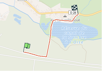
Trail Walking of 971 m to be discovered at Hauts-de-France, Aisne, Boué. This trail is proposed by Rando Famili.

Description

Cité industrielle en milieu rural, Boué vous propose un très joli circuit d'interprétation pour toute la famille où de nombreux panneaux vous décriront la faune et la flore locales.

Elevation profile

Photos

Points of interest

Point of interest Boué - L'étang de Boué - Photo
Rando Famili
Point of interest Boué - Faune et flore de Boué - Photo
Rando Famili

Positioning

Country:
France
Region :
Hauts-de-France
Department/Province :
Aisne
Municipality :
Boué
Location:
Unknown
Start:(Dec)
Start:(UTM)
550325 ; 5539577 (31U) N.

Trails nearby

Trail Walking Étreux - Le Canal - Photo
Walking
tracegps

Walking

Medium
(1)
Étreux, Hauts-de-France, Aisne, France
12.5 km | 13.8 km-effort
3h 15min
Yes
Trail Walking Étreux - Le Canal - variante - Photo
Walking
tracegps

Walking

Medium
Étreux, Hauts-de-France, Aisne, France
10.2 km | 11.2 km-effort
2h 30min
Yes
Trail Walking Fesmy-le-Sart - fesmy_le _sars - Photo
Walking
Michel Zante

Walking

Very easy
(1)
Fesmy-le-Sart, Hauts-de-France, Aisne, France
10.5 km | 11.5 km-effort
2h 27min
Yes
Trail Walking La Neuville-lès-Dorengt - boué ballade le long du cana - Photo
Walking
aspriet

Walking

Very easy
La Neuville-lès-Dorengt, Hauts-de-France, Aisne, France
11.7 km | 12.9 km-effort
2h 41min
No
Trail Running Boué - boué  - Photo
Running
aspriet

Running

Very easy
Boué, Hauts-de-France, Aisne, France
10.8 km | 12.4 km-effort
1h 14min
Yes


Close
My subscriptions