Trail Other activity Glarus Süd - Braunwald ab Friteren - Photo

Braunwald ab Friteren

 jschna
jschna

User

© OpenStreetMap contributors
Length
Length
7.9 km
Max alt
Max alt
1493 m
Uphill gradient
Uphill gradient
368 m
Km-Effort
Km-Effort  
12.7 km
Min alt
Min alt
1217 m
Downhill gradient
Downhill gradient
337 m
Boucle
Boucle
No
Creation date :
2014-12-11 00:00:00.0
Updated on :
2014-12-11 00:00:00.0

(0 Reviews)

Other activity
Other activity
--
Difficulty : Unknown

Scan this QR Code to open this trail in the SityTrail application

FREE GPS app for hiking

Logo SityTrail SityTrail

IGN / Geographical institutes

Download SityTrail from the App Store Download SityTrail from Google Play

Logo SityTrail SityTrail World

The world is yours!

Download SityTrail from the App Store Download SityTrail from Google Play Download SityTrail on Huawei AppGallery

About

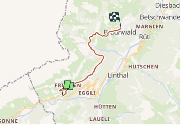
Trail Other activity of 7.9 km to be discovered at Glarus, Unknown, Glarus Süd. This trail is proposed by jschna.

Description

Bei "Friteren" unterhalb von Urnerboden stehen Parkplätze zur Verfügung. Die Waldwege gegen Nussbüel sind meist mit viel Laub bedeckt, sodass bei Gehen über "Stock und Stein" Vorsicht am Platze ist. Ansonsten bietet der Weg eine wunder schöne Aussicht auf die Glarner Alpen und ist problemlos zu bewältigen.Der Rückweg kann auch mit der Braunwldbahn und dem Postbus zu machen.

Elevation profile

Positioning

Country:
Switzerland
Region :
Glarus
Department/Province :
Unknown
Municipality :
Glarus Süd
Location:
Unknown
Start:(UTM)
496890 ; 5195052 (32T) N.

Trails nearby

Trail On foot Glarus Süd - Chalchtrittli-Ochsenstäfeli - Photo
On foot
GUIDE+

On foot

Easy
Glarus Süd, Glarus, Unknown, Switzerland
3.3 km | 10.4 km-effort
2h 21min
No
Trail Other activity Glarus Süd - y10_urnerboden - Photo
Other activity
GUIDE+

Other activity

Very easy
Glarus Süd, Glarus, Unknown, Switzerland
8.4 km | 13.8 km-effort
3h 32min
No
Trail Other activity Glarus Süd - y10_oberblegisee_braunwald - Photo
Other activity
GUIDE+

Other activity

Very easy
Glarus Süd, Glarus, Unknown, Switzerland
16.3 km | 25 km-effort
5h 14min
No
Trail Walking Glarus Süd - passKlausen_passonly - Photo
Walking
GUIDE+

Walking

Very easy
Glarus Süd, Glarus, Unknown, Switzerland
23 km | 38 km-effort
Unknown
No
Trail Walking Glarus Süd - wa38 - Photo
Walking
GUIDE+

Walking

Very easy
Glarus Süd, Glarus, Unknown, Switzerland
9.3 km | 18.4 km-effort
5h 16min
No
Trail Mountain bike Glarus Süd - Bike32870 - Photo
Mountain bike
GUIDE+

Mountain bike

Very easy
Glarus Süd, Glarus, Unknown, Switzerland
8.9 km | 15.6 km-effort
5h 22min
Yes
Trail Walking Glarus Süd - Via Alpina 06b Braunwald - Klausenpass - Photo
Walking
xaviermimi

Walking

Medium
Glarus Süd, Glarus, Unknown, Switzerland
19.3 km | 32 km-effort
6h 37min
No
Trail Other activity Glarus Süd - Brunalpelihöchi - Photo
Other activity
alternatives-wandern

Other activity

Very easy
Glarus Süd, Glarus, Unknown, Switzerland
20 km | 37 km-effort
Unknown
No
Trail Other activity Spiringen - Glatten - Photo
Other activity
rohrh

Other activity

Very easy
Spiringen, Uri, Unknown, Switzerland
19.1 km | 53 km-effort
Unknown
Yes


Close
My subscriptions