![](/images/other/stat-length.png)
le Moulin des loges Mauzac 17 -8 km 400
Jos17
User
![Length](/images/other/stat-length.png)
Length
8.4 km
![Max alt](https://static1.geolcdn.com/siteimages/upload/files/1508320355ic_sort_altitude_max_24dp.png)
Max alt
16 m
![Uphill gradient](https://static1.geolcdn.com/siteimages/upload/files/1508320355ic_sort_den_pos_24dp.png)
Uphill gradient
36 m
![Km-Effort](/images/other/stat-length.png)
Km-Effort
8.9 km
![Min alt](https://static1.geolcdn.com/siteimages/upload/files/1508320355ic_sort_altitude_min_24dp.png)
Min alt
-1 m
![Downhill gradient](https://static1.geolcdn.com/siteimages/upload/files/1508320355ic_sort_den_neg_24dp.png)
Downhill gradient
36 m
![Boucle](https://static1.geolcdn.com/siteimages/upload/files/16400158638029165_repeat_loop_refresh_sync_direction_icon.png)
Boucle
Yes
Creation date :
2019-01-18 20:02:05.113
Updated on :
2024-03-24 15:30:44.069
![On foot](https://static1.geolcdn.com/sitytour/trail-icons/100.png)
2h00
Difficulty : Easy
![Scan this QR Code to open this trail in the SityTrail application](https://capi.geolives.com/qq0zvz2zws4bq2lad0pu/sitytour/trails/2024104/qr.png?size=200)
FREE GPS app for hiking
About
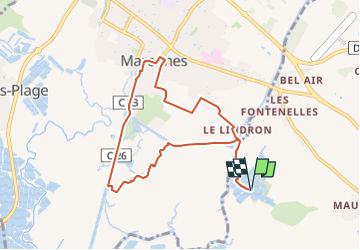
Trail On foot of 8.4 km to be discovered at New Aquitaine, Charente-Maritime, Saint-Just-Luzac. This trail is proposed by Jos17.
Description
Le départ de la rando est au milieu des marais, puis elle longe le canal de Lindron et de la Cayenne, elle pénètre dans Marennes et retourne au Moulin par les marais.
Positioning
Country:
France
Region :
New Aquitaine
Department/Province :
Charente-Maritime
Municipality :
Saint-Just-Luzac
Location:
Unknown
Start:(Dec)
Start:(UTM)
648305 ; 5074204 (30T) N.
Comments
Trails nearby
![Trail Walking Marennes-Hiers-Brouage - Autour de Hiers-Brouage - Photo](https://media.geolcdn.com/t/375/260/ext.jpg?maxdim=2&url=https%3A%2F%2Fservices.sitytrail.com%2FGeolivesWS%2FDownloadMedia.ashx%3FTrailID%3D598577%26Media%3D20160715153348.jpg)
![Walking Walking](https://static1.geolcdn.com/sitytour/trail-icons/101.png)
Autour de Hiers-Brouage
Walking
Easy
(1)
Marennes-Hiers-Brouage,
New Aquitaine,
Charente-Maritime,
France
![](/images/other/stat-length.png)
3.6 km | 4.1 km-effort
1h 4min
![](https://static1.geolcdn.com/siteimages/upload/files/16400158638029165_repeat_loop_refresh_sync_direction_icon.png)
Yes
![Trail Walking Bourcefranc-le-Chapus - Bource Franc - Photo](https://media.geolcdn.com/t/375/260/ext.jpg?maxdim=2&url=https%3A%2F%2Fservices.sitytrail.com%2FGeolivesWS%2FDownloadMedia.ashx%3FTrailID%3D49439%26Media%3Dbcf4.png)
![Walking Walking](https://static1.geolcdn.com/sitytour/trail-icons/101.png)
Bource Franc
Walking
Very easy
(1)
Bourcefranc-le-Chapus,
New Aquitaine,
Charente-Maritime,
France
![](/images/other/stat-length.png)
14.3 km | 15.3 km-effort
Unknown
![](https://static1.geolcdn.com/siteimages/upload/files/16400158638029165_repeat_loop_refresh_sync_direction_icon.png)
No
![Trail Walking Marennes-Hiers-Brouage - marennes 1ere - Photo](https://media.geolcdn.com/t/375/260/ext.jpg?maxdim=2&url=https%3A%2F%2Fstatic1.geolcdn.com%2Fsiteimages%2Fupload%2Ffiles%2F1553511878bg_sport_marche.png)
![Walking Walking](https://static1.geolcdn.com/sitytour/trail-icons/101.png)
marennes 1ere
Walking
Easy
(1)
Marennes-Hiers-Brouage,
New Aquitaine,
Charente-Maritime,
France
![](/images/other/stat-length.png)
6.3 km | 6.7 km-effort
1h 20min
![](https://static1.geolcdn.com/siteimages/upload/files/16400158638029165_repeat_loop_refresh_sync_direction_icon.png)
Yes
![Trail Walking Saint-Just-Luzac - St just luzac - Photo](https://media.geolcdn.com/t/375/260/ext.jpg?maxdim=2&url=https%3A%2F%2Fmedia.geolcdn.com%2Ff%2Fc42343de-f371-4df4-8109-89d03f6af75a.jpg)
![Walking Walking](https://static1.geolcdn.com/sitytour/trail-icons/101.png)
St just luzac
Walking
Very easy
Saint-Just-Luzac,
New Aquitaine,
Charente-Maritime,
France
![](/images/other/stat-length.png)
9.6 km | 10.1 km-effort
2h 17min
![](https://static1.geolcdn.com/siteimages/upload/files/16400158638029165_repeat_loop_refresh_sync_direction_icon.png)
Yes
![Trail On foot Saint-Just-Luzac - La Garenne - St.Just Luzac (2) 17 -9km4 - Photo](https://media.geolcdn.com/t/375/260/ext.jpg?maxdim=2&url=https%3A%2F%2Fmedia.geolcdn.com%2Ff%2Fcdada72f-ef57-4d0d-8dcb-28aafb87c9c4.jpg)
![On foot On foot](https://static1.geolcdn.com/sitytour/trail-icons/100.png)
La Garenne - St.Just Luzac (2) 17 -9km4
On foot
Very easy
Saint-Just-Luzac,
New Aquitaine,
Charente-Maritime,
France
![](/images/other/stat-length.png)
9.4 km | 10 km-effort
Unknown
![](https://static1.geolcdn.com/siteimages/upload/files/16400158638029165_repeat_loop_refresh_sync_direction_icon.png)
Yes
![Trail Walking Marennes-Hiers-Brouage - marennes pâques - Photo](https://media.geolcdn.com/t/375/260/ext.jpg?maxdim=2&url=https%3A%2F%2Fstatic1.geolcdn.com%2Fsiteimages%2Fupload%2Ffiles%2F1553511878bg_sport_marche.png)
![Walking Walking](https://static1.geolcdn.com/sitytour/trail-icons/101.png)
marennes pâques
Walking
Medium
(2)
Marennes-Hiers-Brouage,
New Aquitaine,
Charente-Maritime,
France
![](/images/other/stat-length.png)
10.2 km | 10.8 km-effort
2h 9min
![](https://static1.geolcdn.com/siteimages/upload/files/16400158638029165_repeat_loop_refresh_sync_direction_icon.png)
Yes
![Trail Walking Marennes-Hiers-Brouage - marennes 2eme - Photo](https://media.geolcdn.com/t/375/260/ext.jpg?maxdim=2&url=https%3A%2F%2Fstatic1.geolcdn.com%2Fsiteimages%2Fupload%2Ffiles%2F1553511878bg_sport_marche.png)
![Walking Walking](https://static1.geolcdn.com/sitytour/trail-icons/101.png)
marennes 2eme
Walking
Very easy
(3)
Marennes-Hiers-Brouage,
New Aquitaine,
Charente-Maritime,
France
![](/images/other/stat-length.png)
9.1 km | 9.6 km-effort
2h 9min
![](https://static1.geolcdn.com/siteimages/upload/files/16400158638029165_repeat_loop_refresh_sync_direction_icon.png)
No
![Trail Walking Marennes-Hiers-Brouage - Autour de Hiers-Brouage - Photo](https://media.geolcdn.com/t/375/260/ext.jpg?maxdim=2&url=https%3A%2F%2Fservices.sitytrail.com%2FGeolivesWS%2FDownloadMedia.ashx%3FTrailID%3D598709%26Media%3D20160715153348.jpg)
![Walking Walking](https://static1.geolcdn.com/sitytour/trail-icons/101.png)
Autour de Hiers-Brouage
Walking
Easy
Marennes-Hiers-Brouage,
New Aquitaine,
Charente-Maritime,
France
![](/images/other/stat-length.png)
3.6 km | 4.1 km-effort
1h 4min
![](https://static1.geolcdn.com/siteimages/upload/files/16400158638029165_repeat_loop_refresh_sync_direction_icon.png)
Yes
![Trail Walking La Tremblade - Frank , huitres - Photo](https://media.geolcdn.com/t/375/260/ext.jpg?maxdim=2&url=https%3A%2F%2Fmedia.geolcdn.com%2Ff%2Fe0d27e91-ddad-4e41-97f1-eb3b1cee6287.jpg)
![Walking Walking](https://static1.geolcdn.com/sitytour/trail-icons/101.png)
Frank , huitres
Walking
Easy
La Tremblade,
New Aquitaine,
Charente-Maritime,
France
![](/images/other/stat-length.png)
4.4 km | 4.7 km-effort
9min
![](https://static1.geolcdn.com/siteimages/upload/files/16400158638029165_repeat_loop_refresh_sync_direction_icon.png)
No