![](/images/other/stat-length.png)
![Trail Other activity Quarten - Spitzmeilen ab Flumserberg - Photo](https://media.geolcdn.com/t/1900/400/ext.pjpeg?maxdim=2&url=https%3A%2F%2Fstatic1.geolcdn.com%2Fsiteimages%2Fupload%2Ffiles%2F1545311037marcheuse_200dpi.jpg)
Spitzmeilen ab Flumserberg
jschna
User
![Length](/images/other/stat-length.png)
![Max alt](https://static1.geolcdn.com/siteimages/upload/files/1508320355ic_sort_altitude_max_24dp.png)
![Uphill gradient](https://static1.geolcdn.com/siteimages/upload/files/1508320355ic_sort_den_pos_24dp.png)
![Km-Effort](/images/other/stat-length.png)
![Min alt](https://static1.geolcdn.com/siteimages/upload/files/1508320355ic_sort_altitude_min_24dp.png)
![Downhill gradient](https://static1.geolcdn.com/siteimages/upload/files/1508320355ic_sort_den_neg_24dp.png)
![Boucle](https://static1.geolcdn.com/siteimages/upload/files/16400158638029165_repeat_loop_refresh_sync_direction_icon.png)
![Other activity](https://static1.geolcdn.com/sitytour/trail-icons/900.png)
--
Difficulty : Unknown
![Scan this QR Code to open this trail in the SityTrail application](https://capi.geolives.com/qq0zvz2zws4bq2lad0pu/sitytour/trails/20239/qr.png?size=200)
FREE GPS app for hiking
About
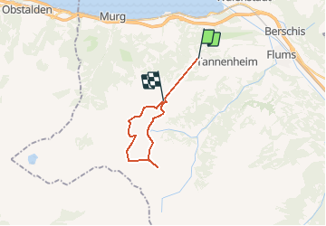
Trail Other activity of 15.6 km to be discovered at Sankt Gallen, Wahlkreis Sarganserland, Quarten. This trail is proposed by jschna.
Description
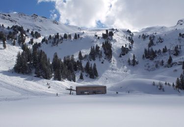
Mit der Luftseilbahn ab Tannenbodenalp zum Maschgenkamm. Den höheren Weg zum Sächsersee einschlagen, so ist der Anstieg nie richtig spürbar. Der Übergang nach links ist etwas ruppig, dann geht es aber wieder relativ bequem bis zur SAC-Hütte. Von der Hütte ein Stück zurück, nach rechts hinunter zur Furschalp. Die Furschalp ist ein Hit. Von da geht es ein Stück der Strasse entlang um dann eine Abkürzung zum Kamm zu nehmen. Reine Marschzeit ist 4:30 h. Fast 2 Stunden rechnen wir für die Pausen
Positioning
Comments
Trails nearby
![Trail Walking Quarten - Höhenwanderung Maschgenkamm-Murgsee - Photo](https://media.geolcdn.com/t/375/260/ext.jpg?maxdim=2&url=https%3A%2F%2Fstatic1.geolcdn.com%2Fsiteimages%2Fupload%2Ffiles%2F1553511878bg_sport_marche.png)
![Walking Walking](https://static1.geolcdn.com/sitytour/trail-icons/101.png)
Walking
![](/images/other/stat-length.png)
![](https://static1.geolcdn.com/siteimages/upload/files/16400158638029165_repeat_loop_refresh_sync_direction_icon.png)
![Trail On foot Walenstadt - Walenstadt - Pluder - Photo](https://media.geolcdn.com/t/375/260/f2f44868-cecd-4f43-90e0-8033a6707992.jpeg&format=jpg&maxdim=2)
![On foot On foot](https://static1.geolcdn.com/sitytour/trail-icons/100.png)
On foot
![](/images/other/stat-length.png)
![](https://static1.geolcdn.com/siteimages/upload/files/16400158638029165_repeat_loop_refresh_sync_direction_icon.png)
![Trail On foot Walenstadt - Pluder - Bergheim Vadella - Photo](https://media.geolcdn.com/t/375/260/a41923a2-5a3b-4b8d-8a8a-9e4f6c4dbf8b.jpeg&format=jpg&maxdim=2)
![On foot On foot](https://static1.geolcdn.com/sitytour/trail-icons/100.png)
On foot
![](/images/other/stat-length.png)
![](https://static1.geolcdn.com/siteimages/upload/files/16400158638029165_repeat_loop_refresh_sync_direction_icon.png)
![Trail On foot Flums - Bergheim Vadella - Bildbrugg - Photo](https://media.geolcdn.com/t/375/260/a41923a2-5a3b-4b8d-8a8a-9e4f6c4dbf8b.jpeg&format=jpg&maxdim=2)
![On foot On foot](https://static1.geolcdn.com/sitytour/trail-icons/100.png)
On foot
![](/images/other/stat-length.png)
![](https://static1.geolcdn.com/siteimages/upload/files/16400158638029165_repeat_loop_refresh_sync_direction_icon.png)
![Trail On foot Flums - 7-Gipfel-Tour - Photo](https://media.geolcdn.com/t/375/260/c2e664f0-e400-4b71-9f4d-996bd72bff79.jpeg&format=jpg&maxdim=2)
![On foot On foot](https://static1.geolcdn.com/sitytour/trail-icons/100.png)
On foot
![](/images/other/stat-length.png)
![](https://static1.geolcdn.com/siteimages/upload/files/16400158638029165_repeat_loop_refresh_sync_direction_icon.png)
![Trail On foot Quarten - Oberterzen - Hessenberg - Photo](https://media.geolcdn.com/t/375/260/635ff4d9-89f4-4d2f-8049-7fc584df7199.jpeg&format=jpg&maxdim=2)
![On foot On foot](https://static1.geolcdn.com/sitytour/trail-icons/100.png)
On foot
![](/images/other/stat-length.png)
![](https://static1.geolcdn.com/siteimages/upload/files/16400158638029165_repeat_loop_refresh_sync_direction_icon.png)
![Trail On foot Quarten - Oberterzen - Heusee - Photo](https://media.geolcdn.com/t/375/260/9af17ee1-00f1-4340-9b59-dc260aba1df2.jpeg&format=jpg&maxdim=2)
![On foot On foot](https://static1.geolcdn.com/sitytour/trail-icons/100.png)
On foot
![](/images/other/stat-length.png)
![](https://static1.geolcdn.com/siteimages/upload/files/16400158638029165_repeat_loop_refresh_sync_direction_icon.png)
![Trail On foot Quarten - Zigerfurgglen - Heusee - Photo](https://media.geolcdn.com/t/375/260/9af17ee1-00f1-4340-9b59-dc260aba1df2.jpeg&format=jpg&maxdim=2)
![On foot On foot](https://static1.geolcdn.com/sitytour/trail-icons/100.png)
On foot
![](/images/other/stat-length.png)
![](https://static1.geolcdn.com/siteimages/upload/files/16400158638029165_repeat_loop_refresh_sync_direction_icon.png)
![Trail On foot Quarten - Rotenberg - Maschgenkamm - Photo](https://media.geolcdn.com/t/375/260/47ae1c87-f47a-4881-99a5-9c0ff652bf5b.jpeg&format=jpg&maxdim=2)
![On foot On foot](https://static1.geolcdn.com/sitytour/trail-icons/100.png)
On foot
![](/images/other/stat-length.png)
![](https://static1.geolcdn.com/siteimages/upload/files/16400158638029165_repeat_loop_refresh_sync_direction_icon.png)