![](/images/other/stat-length.png)
![Trail Walking Saint-Cyr-la-Rosière - Au fil de la Rosière 7,1 Km - Photo](https://media.geolcdn.com/t/1900/400/6ffb02c5-f518-43cf-b25f-e24d8f031465.jpg&format=pjpeg&maxdim=2)
Au fil de la Rosière 7,1 Km
ODDAD78
User
![Length](/images/other/stat-length.png)
![Max alt](https://static1.geolcdn.com/siteimages/upload/files/1508320355ic_sort_altitude_max_24dp.png)
![Uphill gradient](https://static1.geolcdn.com/siteimages/upload/files/1508320355ic_sort_den_pos_24dp.png)
![Km-Effort](/images/other/stat-length.png)
![Min alt](https://static1.geolcdn.com/siteimages/upload/files/1508320355ic_sort_altitude_min_24dp.png)
![Downhill gradient](https://static1.geolcdn.com/siteimages/upload/files/1508320355ic_sort_den_neg_24dp.png)
![Boucle](https://static1.geolcdn.com/siteimages/upload/files/16400158638029165_repeat_loop_refresh_sync_direction_icon.png)
![Walking](https://static1.geolcdn.com/sitytour/trail-icons/101.png)
1h57
Difficulty : Medium
![Scan this QR Code to open this trail in the SityTrail application](https://capi.geolives.com/qq0zvz2zws4bq2lad0pu/sitytour/trails/2023008/qr.png?size=200)
FREE GPS app for hiking
About
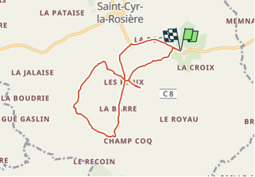
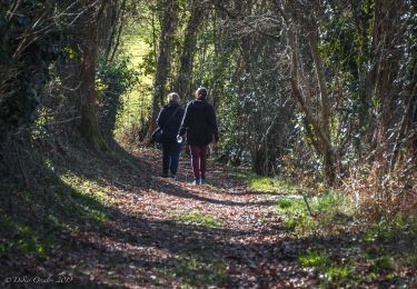
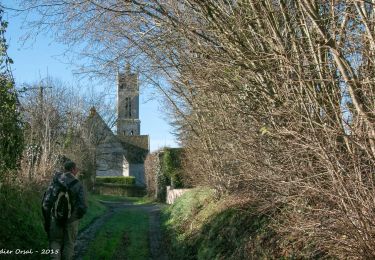
Trail Walking of 7.1 km to be discovered at Normandy, Orne, Saint-Cyr-la-Rosière. This trail is proposed by ODDAD78.
Description
Circuit balisé et jaune signalétique (suivre les flèches "Au fil de la Rosière")
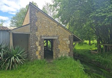
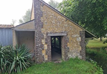
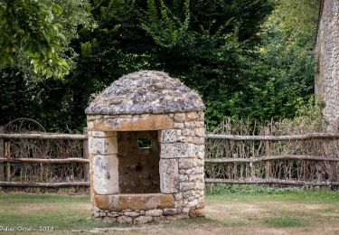
La Rosière figure parmi les anciennes seigneuries du Perche, Le premier château, construit sur une moite, a été rem- placé par un grand corps de logis comprenant notamment trois chambres basses et trois chambres hautes à cheminée, Dans le jardin clos de la ferme existe encore la chapelle Saint-Antoine, fondée en 1535 et, dans la cour, la tour ronde d’une fuie,
Commentaire :
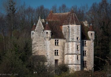
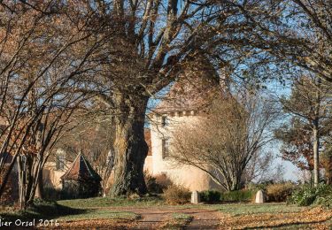
L'Angenardière, l'un des plus beaux manoirs du Perche, a une allure médiévale. Pierre de Fontenay, son constructeur, craignait-il un retour aux années sombres des Guerres de Religion où voulait-il posséder un château qui fasse honneur à ses titres de Gouverneur pour le roi des ville et châteou de Bellême et du pays du Perche.
Élevée sur un plan carré, la demeure est close de murs et de fossés. On pénétrait dans la basse-cour par un pont-levis, Le logis XVIé, flanqué de deux grosses tours rondes à mâchicoulis, est relié à l'une des tours d'angle par une élégante galerie “à l'italienne",
L'enceinte est soulignée par quatre tours. La plus massive est celle du colombier aux nombreux boulins, accessibles par une échelle tournante, La plus petite abritait la chapelle seigneuriale.
Positioning
Comments
Trails nearby
![Trail Walking Perche en Nocé - Préaux-du-Perche Nord - Photo](https://media.geolcdn.com/t/375/260/a79e2268-207b-49cb-8d2a-d633dd57f73d.jpg&format=jpg&maxdim=2)
![Walking Walking](https://static1.geolcdn.com/sitytour/trail-icons/101.png)
Walking
![](/images/other/stat-length.png)
![](https://static1.geolcdn.com/siteimages/upload/files/16400158638029165_repeat_loop_refresh_sync_direction_icon.png)
![Trail Walking La Chapelle-Souëf - La Chapelle Souef - Les Feugerets 12 Km - Photo](https://media.geolcdn.com/t/375/260/ext.jpg?maxdim=2&url=https%3A%2F%2Fstatic1.geolcdn.com%2Fsiteimages%2Fupload%2Ffiles%2F1553511878bg_sport_marche.png)
![Walking Walking](https://static1.geolcdn.com/sitytour/trail-icons/101.png)
Walking
![](/images/other/stat-length.png)
![](https://static1.geolcdn.com/siteimages/upload/files/16400158638029165_repeat_loop_refresh_sync_direction_icon.png)
![Trail Walking Perche en Nocé - Préaux-du-Perche Sud - Photo](https://media.geolcdn.com/t/375/260/0969c1bf-78c8-4ceb-9cf9-65ed34443adf.jpg&format=jpg&maxdim=2)
![Walking Walking](https://static1.geolcdn.com/sitytour/trail-icons/101.png)
Walking
![](/images/other/stat-length.png)
![](https://static1.geolcdn.com/siteimages/upload/files/16400158638029165_repeat_loop_refresh_sync_direction_icon.png)
![Trail Walking Perche en Nocé - Nocé-Courboyer - Saint-Aubin-des-Grois 9,5 km - Photo](https://media.geolcdn.com/t/375/260/74d7cd8d-75a9-4a6d-8570-ba2a55254fab.jpg&format=jpg&maxdim=2)
![Walking Walking](https://static1.geolcdn.com/sitytour/trail-icons/101.png)
Walking
![](/images/other/stat-length.png)
![](https://static1.geolcdn.com/siteimages/upload/files/16400158638029165_repeat_loop_refresh_sync_direction_icon.png)
![Trail Walking Perche en Nocé - Val d'Enfer 17Km - Photo](https://media.geolcdn.com/t/375/260/285f82a6-4b4a-437a-b428-48270f65e19b.jpg&format=jpg&maxdim=2)
![Walking Walking](https://static1.geolcdn.com/sitytour/trail-icons/101.png)
Walking
![](/images/other/stat-length.png)
![](https://static1.geolcdn.com/siteimages/upload/files/16400158638029165_repeat_loop_refresh_sync_direction_icon.png)
![Trail Walking Perche en Nocé - Nobles logis (Préaux-du-Perche) 9,4Km - Photo](https://media.geolcdn.com/t/375/260/4db8b454-889b-47d7-bd12-5d83e5cd02fb.jpg&format=jpg&maxdim=2)
![Walking Walking](https://static1.geolcdn.com/sitytour/trail-icons/101.png)
Walking
![](/images/other/stat-length.png)
![](https://static1.geolcdn.com/siteimages/upload/files/16400158638029165_repeat_loop_refresh_sync_direction_icon.png)
![Trail Walking Perche en Nocé - Les Panoramas 5,5 Km - Photo](https://media.geolcdn.com/t/375/260/3ecdb278-3826-4aa6-b1de-61f0366a9a2c.jpg&format=jpg&maxdim=2)
![Walking Walking](https://static1.geolcdn.com/sitytour/trail-icons/101.png)
Walking
![](/images/other/stat-length.png)
![](https://static1.geolcdn.com/siteimages/upload/files/16400158638029165_repeat_loop_refresh_sync_direction_icon.png)
![Trail Walking Val-au-Perche - Gémages - Igé 15 km - Photo](https://media.geolcdn.com/t/375/260/ca29e4ed-f1c5-43dc-8f3b-a7ce5ca4d85c.jpg&format=jpg&maxdim=2)
![Walking Walking](https://static1.geolcdn.com/sitytour/trail-icons/101.png)
Walking
![](/images/other/stat-length.png)
![](https://static1.geolcdn.com/siteimages/upload/files/16400158638029165_repeat_loop_refresh_sync_direction_icon.png)
![Trail Walking Val-au-Perche - Gémages - Igé via Appenai-sous-Bellême 17 km - Photo](https://media.geolcdn.com/t/375/260/ea7eb4fa-cd97-4b60-8fba-343bfd613697.jpg&format=jpg&maxdim=2)
![Walking Walking](https://static1.geolcdn.com/sitytour/trail-icons/101.png)
Walking
![](/images/other/stat-length.png)
![](https://static1.geolcdn.com/siteimages/upload/files/16400158638029165_repeat_loop_refresh_sync_direction_icon.png)