![Trail Mountain bike ຄອນເຫນືອ - Don Den - Photo](https://media.geolcdn.com/t/1900/400/ext.pjpeg?maxdim=2&url=https%3A%2F%2Fstatic1.geolcdn.com%2Fsiteimages%2Fupload%2Ffiles%2F1524743154velo.jpg)
Don Den
Kargil
User GUIDE
![Length](/images/other/stat-length.png)
Length
14.1 km
![Max alt](https://static1.geolcdn.com/siteimages/upload/files/1508320355ic_sort_altitude_max_24dp.png)
Max alt
92 m
![Uphill gradient](https://static1.geolcdn.com/siteimages/upload/files/1508320355ic_sort_den_pos_24dp.png)
Uphill gradient
123 m
![Km-Effort](/images/other/stat-length.png)
Km-Effort
15.7 km
![Min alt](https://static1.geolcdn.com/siteimages/upload/files/1508320355ic_sort_altitude_min_24dp.png)
Min alt
58 m
![Downhill gradient](https://static1.geolcdn.com/siteimages/upload/files/1508320355ic_sort_den_neg_24dp.png)
Downhill gradient
126 m
![Boucle](https://static1.geolcdn.com/siteimages/upload/files/16400158638029165_repeat_loop_refresh_sync_direction_icon.png)
Boucle
Yes
Creation date :
2019-01-09 03:03:04.238
Updated on :
2020-01-12 11:15:29.358
![Mountain bike](https://static1.geolcdn.com/sitytour/trail-icons/202.png)
3h38
Difficulty : Easy
![Scan this QR Code to open this trail in the SityTrail application](https://capi.geolives.com/qq0zvz2zws4bq2lad0pu/sitytour/trails/2022047/qr.png?size=200)
FREE GPS app for hiking
About
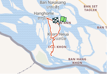
Trail Mountain bike of 14.1 km to be discovered at Champasak Province, Khong District. This trail is proposed by Kargil.
Positioning
Country:
Lao People's Democratic Republic
Region :
Champasak Province
Department/Province :
Khong District
Municipality :
ຄອນເຫນືອ
Location:
Unknown
Start:(Dec)
Start:(UTM)
600167 ; 1545499 (48P) N.
Comments
Trails nearby