Trail Walking Houay Tômô - Tomo Temple - Photo
 Kargil
Kargil

User GUIDE

© OpenStreetMap contributors
Length
Length
17.5 km
Max alt
Max alt
120 m
Uphill gradient
Uphill gradient
104 m
Km-Effort
Km-Effort  
18.9 km
Min alt
Min alt
88 m
Downhill gradient
Downhill gradient
92 m
Boucle
Boucle
No
Creation date :
2019-01-02 04:24:48.771
Updated on :
2020-01-12 11:16:34.963

(0 Reviews)

Walking
Walking
4h00
Difficulty : Very easy
Motorboat
Motorboat
--
Difficulty : Very easy

Scan this QR Code to open this trail in the SityTrail application

FREE GPS app for hiking

Logo SityTrail SityTrail

IGN / Geographical institutes

Download SityTrail from the App Store Download SityTrail from Google Play

Logo SityTrail SityTrail World

The world is yours!

Download SityTrail from the App Store Download SityTrail from Google Play Download SityTrail on Huawei AppGallery

About

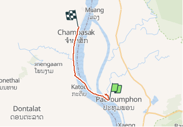
Trail Walking of 17.5 km to be discovered at Champasak Province, Pathouphone District. This trail is proposed by Kargil.

Description

Grande partie faite en bateau sur le  Mekong.
C'est la partie plate du profil.

Elevation profile

Photos

Positioning

Country:
Lao People's Democratic Republic
Region :
Champasak Province
Department/Province :
Pathouphone District
Municipality :
Houay Tômô
Location:
Unknown
Start:(UTM)
599167 ; 1636823 (48P) N.

Trails nearby

Trail Walking  - Trek Ban Kiet Ngong Jour 3 - Photo
Walking
GUIDE
Kargil

Walking

Difficult
, Champasak Province, Pathouphone District, Lao People's Democratic Republic
12.9 km | 15.1 km-effort
5h 12min
No


Close
My subscriptions