![](/images/other/stat-length.png)
![Trail Walking Braine-l’Alleud - Wikiloc - Lillois mtherese - Photo](https://media.geolcdn.com/t/1900/400/ext.pjpeg?maxdim=2&url=https%3A%2F%2Fstatic1.geolcdn.com%2Fsiteimages%2Fupload%2Ffiles%2F1553511878bg_sport_marche.png)
Wikiloc - Lillois mtherese
calofrancis
User
![Length](/images/other/stat-length.png)
Length
5.1 km
![Max alt](https://static1.geolcdn.com/siteimages/upload/files/1508320355ic_sort_altitude_max_24dp.png)
Max alt
152 m
![Uphill gradient](https://static1.geolcdn.com/siteimages/upload/files/1508320355ic_sort_den_pos_24dp.png)
Uphill gradient
42 m
![Km-Effort](/images/other/stat-length.png)
Km-Effort
5.7 km
![Min alt](https://static1.geolcdn.com/siteimages/upload/files/1508320355ic_sort_altitude_min_24dp.png)
Min alt
126 m
![Downhill gradient](https://static1.geolcdn.com/siteimages/upload/files/1508320355ic_sort_den_neg_24dp.png)
Downhill gradient
42 m
![Boucle](https://static1.geolcdn.com/siteimages/upload/files/16400158638029165_repeat_loop_refresh_sync_direction_icon.png)
Boucle
Yes
Creation date :
2018-12-09 13:53:22.179
Updated on :
2018-12-09 13:55:49.042
![Walking](https://static1.geolcdn.com/sitytour/trail-icons/101.png)
1h15
Difficulty : Easy
![Scan this QR Code to open this trail in the SityTrail application](https://capi.geolives.com/qq0zvz2zws4bq2lad0pu/sitytour/trails/2019077/qr.png?size=200)
FREE GPS app for hiking
About
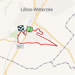
Trail Walking of 5.1 km to be discovered at Wallonia, Walloon Brabant, Braine-l’Alleud. This trail is proposed by calofrancis.
Description
Au départ du parking du Proxi de Lillois, un petit parcours dans le quartier du Vert Coucou et retour par le lotissement des oiseaux ...
Positioning
Country:
Belgium
Region :
Wallonia
Department/Province :
Walloon Brabant
Municipality :
Braine-l’Alleud
Location:
Lillois-Witterzée
Start:(Dec)
Start:(UTM)
596212 ; 5610516 (31U) N.
Comments
Trails nearby
![Trail Walking Braine-l’Alleud - RB-Bw-13_Braine-l'Alleud - Photo](https://media.geolcdn.com/t/375/260/ext.jpg?maxdim=2&url=https%3A%2F%2Fservices.sitytrail.com%2FGeolivesWS%2FDownloadMedia.ashx%3FTrailID%3D179588%26Media%3D9ffdd7b7-2039-4356-b235-ee33d9a18bd7.jpg)
![Walking Walking](https://static1.geolcdn.com/sitytour/trail-icons/101.png)
RB-Bw-13_Braine-l'Alleud
Walking
Very difficult
(5)
Braine-l’Alleud,
Wallonia,
Walloon Brabant,
Belgium
![](/images/other/stat-length.png)
21 km | 27 km-effort
6h 2min
![](https://static1.geolcdn.com/siteimages/upload/files/16400158638029165_repeat_loop_refresh_sync_direction_icon.png)
Yes
![Trail Walking Braine-l’Alleud - RB-Bw-13 - Raccourci - Le Hain entre deux Braines - Photo](https://media.geolcdn.com/t/375/260/ext.jpg?maxdim=2&url=https%3A%2F%2Fservices.sitytrail.com%2FGeolivesWS%2FDownloadMedia.ashx%3FTrailID%3D220430%26Media%3D9ffdd7b7-2039-4356-b235-ee33d9a18bd7.jpg)
![Walking Walking](https://static1.geolcdn.com/sitytour/trail-icons/101.png)
RB-Bw-13 - Raccourci - Le Hain entre deux Braines
Walking
Difficult
(6)
Braine-l’Alleud,
Wallonia,
Walloon Brabant,
Belgium
![](/images/other/stat-length.png)
14.8 km | 18.8 km-effort
4h 16min
![](https://static1.geolcdn.com/siteimages/upload/files/16400158638029165_repeat_loop_refresh_sync_direction_icon.png)
Yes
![Trail Mountain bike Braine-l’Alleud - O2bikers_58_Waterloo - Photo](https://media.geolcdn.com/t/375/260/ext.jpg?maxdim=2&url=https%3A%2F%2Fstatic1.geolcdn.com%2Fsiteimages%2Fupload%2Ffiles%2F1524743154velo.jpg)
![Mountain bike Mountain bike](https://static1.geolcdn.com/sitytour/trail-icons/202.png)
O2bikers_58_Waterloo
Mountain bike
Very easy
(5)
Braine-l’Alleud,
Wallonia,
Walloon Brabant,
Belgium
![](/images/other/stat-length.png)
30 km | 37 km-effort
4h 11min
![](https://static1.geolcdn.com/siteimages/upload/files/16400158638029165_repeat_loop_refresh_sync_direction_icon.png)
Yes
![Mountain bike Mountain bike](https://static1.geolcdn.com/sitytour/trail-icons/202.png)
VTT a plancenoit
Mountain bike
Difficult
(1)
Lasne,
Wallonia,
Walloon Brabant,
Belgium
![](/images/other/stat-length.png)
28 km | 34 km-effort
2h 20min
![](https://static1.geolcdn.com/siteimages/upload/files/16400158638029165_repeat_loop_refresh_sync_direction_icon.png)
Yes
![Trail Mountain bike Waterloo - De Waterloo à la forêt de Soignes - Photo](https://media.geolcdn.com/t/375/260/ext.jpg?maxdim=2&url=https%3A%2F%2Fservices.sitytrail.com%2FGeolivesWS%2FDownloadMedia.ashx%3FTrailID%3D688453%26Media%3D31ac41f9-68d5-4a4a-9a8e-a882e9787769.JPG)
![Mountain bike Mountain bike](https://static1.geolcdn.com/sitytour/trail-icons/202.png)
De Waterloo à la forêt de Soignes
Mountain bike
Medium
(1)
Waterloo,
Wallonia,
Walloon Brabant,
Belgium
![](/images/other/stat-length.png)
39 km | 47 km-effort
3h 1min
![](https://static1.geolcdn.com/siteimages/upload/files/16400158638029165_repeat_loop_refresh_sync_direction_icon.png)
Yes
![Trail Walking Braine-l’Alleud - #221003 - Braine-l'Alleud, Timpe et Tard et Bois du Foriest, Parc et Lac du Paradis*** - Photo](https://media.geolcdn.com/t/375/260/7ca9587d-0fe0-4627-96a6-2d18fe7f584a.jpg&format=jpg&maxdim=2)
![Walking Walking](https://static1.geolcdn.com/sitytour/trail-icons/101.png)
#221003 - Braine-l'Alleud, Timpe et Tard et Bois du Foriest, Parc et Lac du P...
Walking
Medium
(1)
Braine-l’Alleud,
Wallonia,
Walloon Brabant,
Belgium
![](/images/other/stat-length.png)
8.1 km | 9.8 km-effort
2h 13min
![](https://static1.geolcdn.com/siteimages/upload/files/16400158638029165_repeat_loop_refresh_sync_direction_icon.png)
Yes
![Walking Walking](https://static1.geolcdn.com/sitytour/trail-icons/101.png)
RB 11 Plancenoit - Lasnes
Walking
Easy
(1)
Lasne,
Wallonia,
Walloon Brabant,
Belgium
![](/images/other/stat-length.png)
12.8 km | 15.6 km-effort
2h 42min
![](https://static1.geolcdn.com/siteimages/upload/files/16400158638029165_repeat_loop_refresh_sync_direction_icon.png)
Yes
![Trail Walking Braine-l’Alleud - Promenade 1815 - Photo](https://media.geolcdn.com/t/375/260/a5c88808-562a-4352-bf02-99aedd3ac634.jpg&format=jpg&maxdim=2)
![Walking Walking](https://static1.geolcdn.com/sitytour/trail-icons/101.png)
Promenade 1815
Walking
Difficult
(3)
Braine-l’Alleud,
Wallonia,
Walloon Brabant,
Belgium
![](/images/other/stat-length.png)
14.4 km | 16.7 km-effort
3h 39min
![](https://static1.geolcdn.com/siteimages/upload/files/16400158638029165_repeat_loop_refresh_sync_direction_icon.png)
Yes
![Trail Walking Lasne - Francine - Photo](https://media.geolcdn.com/t/375/260/ext.jpg?maxdim=2&url=https%3A%2F%2Fservices.sitytrail.com%2FGeolivesWS%2FDownloadMedia.ashx%3FTrailID%3D730257%26Media%3D20170410155534.jpg)
![Walking Walking](https://static1.geolcdn.com/sitytour/trail-icons/101.png)
Francine
Walking
Medium
(1)
Lasne,
Wallonia,
Walloon Brabant,
Belgium
![](/images/other/stat-length.png)
9.3 km | 11.5 km-effort
2h 59min
![](https://static1.geolcdn.com/siteimages/upload/files/16400158638029165_repeat_loop_refresh_sync_direction_icon.png)
Yes