![](/images/other/stat-length.png)
![Trail Walking Braine-l’Alleud - Wikiloc - Ophain-Bois-Seigneur-Isaac - Photo](https://media.geolcdn.com/t/1900/400/ext.pjpeg?maxdim=2&url=https%3A%2F%2Fstatic1.geolcdn.com%2Fsiteimages%2Fupload%2Ffiles%2F1553511878bg_sport_marche.png)
Wikiloc - Ophain-Bois-Seigneur-Isaac
calofrancis
User
![Length](/images/other/stat-length.png)
Length
4.4 km
![Max alt](https://static1.geolcdn.com/siteimages/upload/files/1508320355ic_sort_altitude_max_24dp.png)
Max alt
129 m
![Uphill gradient](https://static1.geolcdn.com/siteimages/upload/files/1508320355ic_sort_den_pos_24dp.png)
Uphill gradient
62 m
![Km-Effort](/images/other/stat-length.png)
Km-Effort
5.2 km
![Min alt](https://static1.geolcdn.com/siteimages/upload/files/1508320355ic_sort_altitude_min_24dp.png)
Min alt
92 m
![Downhill gradient](https://static1.geolcdn.com/siteimages/upload/files/1508320355ic_sort_den_neg_24dp.png)
Downhill gradient
71 m
![Boucle](https://static1.geolcdn.com/siteimages/upload/files/16400158638029165_repeat_loop_refresh_sync_direction_icon.png)
Boucle
No
Creation date :
2018-12-09 13:42:50.999
Updated on :
2018-12-09 13:46:42.223
![Walking](https://static1.geolcdn.com/sitytour/trail-icons/101.png)
1h08
Difficulty : Easy
![Scan this QR Code to open this trail in the SityTrail application](https://capi.geolives.com/qq0zvz2zws4bq2lad0pu/sitytour/trails/2019076/qr.png?size=200)
FREE GPS app for hiking
About
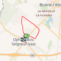
Trail Walking of 4.4 km to be discovered at Wallonia, Walloon Brabant, Braine-l’Alleud. This trail is proposed by calofrancis.
Description
Au départ du parking en face du terrain de sport ... en passant par le sentier de la justice et le quartier de Timpe et Tard.
Positioning
Country:
Belgium
Region :
Wallonia
Department/Province :
Walloon Brabant
Municipality :
Braine-l’Alleud
Location:
Ophain-Bois-Seigneur-Isaac
Start:(Dec)
Start:(UTM)
595260 ; 5613561 (31U) N.
Comments
Trails nearby
![Trail Walking Braine-l’Alleud - RB-Bw-13_Braine-l'Alleud - Photo](https://media.geolcdn.com/t/375/260/ext.jpg?maxdim=2&url=https%3A%2F%2Fservices.sitytrail.com%2FGeolivesWS%2FDownloadMedia.ashx%3FTrailID%3D179588%26Media%3D9ffdd7b7-2039-4356-b235-ee33d9a18bd7.jpg)
![Walking Walking](https://static1.geolcdn.com/sitytour/trail-icons/101.png)
RB-Bw-13_Braine-l'Alleud
Walking
Very difficult
(5)
Braine-l’Alleud,
Wallonia,
Walloon Brabant,
Belgium
![](/images/other/stat-length.png)
21 km | 27 km-effort
6h 2min
![](https://static1.geolcdn.com/siteimages/upload/files/16400158638029165_repeat_loop_refresh_sync_direction_icon.png)
Yes
![Trail Walking Braine-l’Alleud - RB-Bw-13 - Raccourci - Le Hain entre deux Braines - Photo](https://media.geolcdn.com/t/375/260/ext.jpg?maxdim=2&url=https%3A%2F%2Fservices.sitytrail.com%2FGeolivesWS%2FDownloadMedia.ashx%3FTrailID%3D220430%26Media%3D9ffdd7b7-2039-4356-b235-ee33d9a18bd7.jpg)
![Walking Walking](https://static1.geolcdn.com/sitytour/trail-icons/101.png)
RB-Bw-13 - Raccourci - Le Hain entre deux Braines
Walking
Difficult
(6)
Braine-l’Alleud,
Wallonia,
Walloon Brabant,
Belgium
![](/images/other/stat-length.png)
14.8 km | 18.8 km-effort
4h 16min
![](https://static1.geolcdn.com/siteimages/upload/files/16400158638029165_repeat_loop_refresh_sync_direction_icon.png)
Yes
![Trail Mountain bike Braine-l’Alleud - O2bikers_58_Waterloo - Photo](https://media.geolcdn.com/t/375/260/ext.jpg?maxdim=2&url=https%3A%2F%2Fstatic1.geolcdn.com%2Fsiteimages%2Fupload%2Ffiles%2F1524743154velo.jpg)
![Mountain bike Mountain bike](https://static1.geolcdn.com/sitytour/trail-icons/202.png)
O2bikers_58_Waterloo
Mountain bike
Very easy
(5)
Braine-l’Alleud,
Wallonia,
Walloon Brabant,
Belgium
![](/images/other/stat-length.png)
30 km | 37 km-effort
4h 11min
![](https://static1.geolcdn.com/siteimages/upload/files/16400158638029165_repeat_loop_refresh_sync_direction_icon.png)
Yes
![Trail Mountain bike Waterloo - De Waterloo à la forêt de Soignes - Photo](https://media.geolcdn.com/t/375/260/ext.jpg?maxdim=2&url=https%3A%2F%2Fservices.sitytrail.com%2FGeolivesWS%2FDownloadMedia.ashx%3FTrailID%3D688453%26Media%3D31ac41f9-68d5-4a4a-9a8e-a882e9787769.JPG)
![Mountain bike Mountain bike](https://static1.geolcdn.com/sitytour/trail-icons/202.png)
De Waterloo à la forêt de Soignes
Mountain bike
Medium
(1)
Waterloo,
Wallonia,
Walloon Brabant,
Belgium
![](/images/other/stat-length.png)
39 km | 47 km-effort
3h 1min
![](https://static1.geolcdn.com/siteimages/upload/files/16400158638029165_repeat_loop_refresh_sync_direction_icon.png)
Yes
![Trail Walking Halle - Balade dans le Bois de Halle - Photo](https://media.geolcdn.com/t/375/260/ext.jpg?maxdim=2&url=https%3A%2F%2Fservices.sitytrail.com%2FGeolivesWS%2FDownloadMedia.ashx%3FTrailID%3D411974%26Media%3D4cfcce27-edaf-4211-9dbe-1277fff36f47.JPG)
![Walking Walking](https://static1.geolcdn.com/sitytour/trail-icons/101.png)
Balade dans le Bois de Halle
Walking
Easy
(2)
Halle,
Flanders,
Flemish Brabant,
Belgium
![](/images/other/stat-length.png)
8.6 km | 10.5 km-effort
2h 14min
![](https://static1.geolcdn.com/siteimages/upload/files/16400158638029165_repeat_loop_refresh_sync_direction_icon.png)
Yes
![Trail Walking Braine-l’Alleud - #221003 - Braine-l'Alleud, Timpe et Tard et Bois du Foriest, Parc et Lac du Paradis*** - Photo](https://media.geolcdn.com/t/375/260/7ca9587d-0fe0-4627-96a6-2d18fe7f584a.jpg&format=jpg&maxdim=2)
![Walking Walking](https://static1.geolcdn.com/sitytour/trail-icons/101.png)
#221003 - Braine-l'Alleud, Timpe et Tard et Bois du Foriest, Parc et Lac du P...
Walking
Medium
(1)
Braine-l’Alleud,
Wallonia,
Walloon Brabant,
Belgium
![](/images/other/stat-length.png)
8.1 km | 9.8 km-effort
2h 13min
![](https://static1.geolcdn.com/siteimages/upload/files/16400158638029165_repeat_loop_refresh_sync_direction_icon.png)
Yes
![Trail Walking Braine-l’Alleud - Promenade 1815 - Photo](https://media.geolcdn.com/t/375/260/a5c88808-562a-4352-bf02-99aedd3ac634.jpg&format=jpg&maxdim=2)
![Walking Walking](https://static1.geolcdn.com/sitytour/trail-icons/101.png)
Promenade 1815
Walking
Difficult
(3)
Braine-l’Alleud,
Wallonia,
Walloon Brabant,
Belgium
![](/images/other/stat-length.png)
14.4 km | 16.7 km-effort
3h 39min
![](https://static1.geolcdn.com/siteimages/upload/files/16400158638029165_repeat_loop_refresh_sync_direction_icon.png)
Yes
![Trail Walking Halle - bois de halle hallerbos - Photo](https://media.geolcdn.com/t/375/260/171c7fd8-9c79-49a4-b4c2-e78fc47fb1c7.jpg&format=jpg&maxdim=2)
![Walking Walking](https://static1.geolcdn.com/sitytour/trail-icons/101.png)
bois de halle hallerbos
Walking
Very easy
(1)
Halle,
Flanders,
Flemish Brabant,
Belgium
![](/images/other/stat-length.png)
7.1 km | 8.6 km-effort
1h 35min
![](https://static1.geolcdn.com/siteimages/upload/files/16400158638029165_repeat_loop_refresh_sync_direction_icon.png)
Yes
![Trail Walking Braine-l’Alleud - BLA_0223 XL - Photo](https://media.geolcdn.com/t/375/260/ext.jpg?maxdim=2&url=https%3A%2F%2Fstatic1.geolcdn.com%2Fsiteimages%2Fupload%2Ffiles%2F1553511878bg_sport_marche.png)
![Walking Walking](https://static1.geolcdn.com/sitytour/trail-icons/101.png)
BLA_0223 XL
Walking
Medium
(1)
Braine-l’Alleud,
Wallonia,
Walloon Brabant,
Belgium
![](/images/other/stat-length.png)
9.4 km | 10.8 km-effort
1h 57min
![](https://static1.geolcdn.com/siteimages/upload/files/16400158638029165_repeat_loop_refresh_sync_direction_icon.png)
Yes
Jolies vues sur la campagne et Braine-l’Alleud.