![](/images/other/stat-length.png)
![Trail Walking Hulluch - Campagne au milieu des](https://media.geolcdn.com/t/1900/400/ext.pjpeg?maxdim=2&url=https%3A%2F%2Fstatic1.geolcdn.com%2Fsiteimages%2Fupload%2Ffiles%2F1553511878bg_sport_marche.png)
Campagne au milieu des "champs de mines"
dautriche
User
![Length](/images/other/stat-length.png)
Length
21 km
![Max alt](https://static1.geolcdn.com/siteimages/upload/files/1508320355ic_sort_altitude_max_24dp.png)
Max alt
50 m
![Uphill gradient](https://static1.geolcdn.com/siteimages/upload/files/1508320355ic_sort_den_pos_24dp.png)
Uphill gradient
98 m
![Km-Effort](/images/other/stat-length.png)
Km-Effort
22 km
![Min alt](https://static1.geolcdn.com/siteimages/upload/files/1508320355ic_sort_altitude_min_24dp.png)
Min alt
19 m
![Downhill gradient](https://static1.geolcdn.com/siteimages/upload/files/1508320355ic_sort_den_neg_24dp.png)
Downhill gradient
98 m
![Boucle](https://static1.geolcdn.com/siteimages/upload/files/16400158638029165_repeat_loop_refresh_sync_direction_icon.png)
Boucle
Yes
Creation date :
2018-11-22 12:42:22.655
Updated on :
2018-11-22 18:17:08.263
![Walking](https://static1.geolcdn.com/sitytour/trail-icons/101.png)
4h59
Difficulty : Easy
![Scan this QR Code to open this trail in the SityTrail application](https://capi.geolives.com/qq0zvz2zws4bq2lad0pu/sitytour/trails/2017523/qr.png?size=200)
FREE GPS app for hiking
About
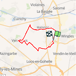
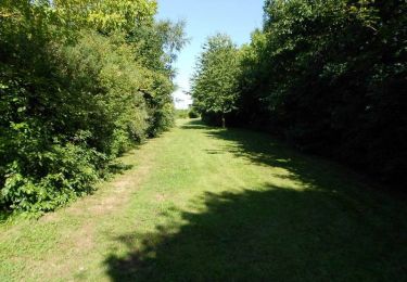
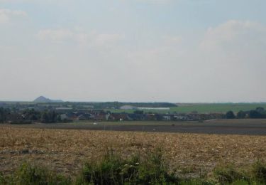
Trail Walking of 21 km to be discovered at Hauts-de-France, Pas-de-Calais, Hulluch. This trail is proposed by dautriche.
Description
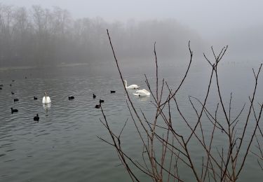
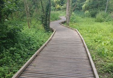
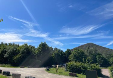
Etonnante campagne "vierge" autour du terril de la fosse 13 et au milieu des fosses du bassin minier de Lens et Béthune. 21 km de nature surprenante dans ce paysage imaginé comme urbain proche du siège de la fosse Germinal ...
Positioning
Country:
France
Region :
Hauts-de-France
Department/Province :
Pas-de-Calais
Municipality :
Hulluch
Location:
Unknown
Start:(Dec)
Start:(UTM)
487611 ; 5592947 (31U) N.
Comments
Trails nearby
![Trail Hybrid bike Wingles - Wingles parc de la souchez - Photo](https://media.geolcdn.com/t/375/260/ext.jpg?maxdim=2&url=https%3A%2F%2Fstatic1.geolcdn.com%2Fsiteimages%2Fupload%2Ffiles%2F1524743154velo.jpg)
![Hybrid bike Hybrid bike](https://static1.geolcdn.com/sitytour/trail-icons/203.png)
Wingles parc de la souchez
Hybrid bike
(1)
Wingles,
Hauts-de-France,
Pas-de-Calais,
France
![](/images/other/stat-length.png)
34 km | 36 km-effort
1h 53min
![](https://static1.geolcdn.com/siteimages/upload/files/16400158638029165_repeat_loop_refresh_sync_direction_icon.png)
Yes
![Trail Walking Wingles - wingles reco - Photo](https://media.geolcdn.com/t/375/260/d31f0e14-4502-46fe-8a48-24e58a4b23d3.jpg&format=jpg&maxdim=2)
![Walking Walking](https://static1.geolcdn.com/sitytour/trail-icons/101.png)
wingles reco
Walking
Medium
Wingles,
Hauts-de-France,
Pas-de-Calais,
France
![](/images/other/stat-length.png)
10.2 km | 11.2 km-effort
1h 53min
![](https://static1.geolcdn.com/siteimages/upload/files/16400158638029165_repeat_loop_refresh_sync_direction_icon.png)
Yes
![Trail Walking La Bassée - La Basée 13 km - Photo](https://media.geolcdn.com/t/375/260/f1bdc64b-513c-470e-8886-00ca936919a9.jpg&format=jpg&maxdim=2)
![Walking Walking](https://static1.geolcdn.com/sitytour/trail-icons/101.png)
La Basée 13 km
Walking
Easy
La Bassée,
Hauts-de-France,
Nord,
France
![](/images/other/stat-length.png)
13 km | 13.7 km-effort
3h 26min
![](https://static1.geolcdn.com/siteimages/upload/files/16400158638029165_repeat_loop_refresh_sync_direction_icon.png)
Yes
![Trail Walking Bauvin - Wingles - Photo](https://media.geolcdn.com/t/375/260/4ad96d20-0522-45e1-a005-6177e2c8edea.jpg&format=jpg&maxdim=2)
![Walking Walking](https://static1.geolcdn.com/sitytour/trail-icons/101.png)
![Trail Electric bike Wingles - Wingles BÈthune vimy - Photo](https://media.geolcdn.com/t/375/260/1f50935e-e323-432c-ae4c-ec8457404502.jpg&format=jpg&maxdim=2)
![Electric bike Electric bike](https://static1.geolcdn.com/sitytour/trail-icons/205.png)
Wingles BÈthune vimy
Electric bike
Medium
Wingles,
Hauts-de-France,
Pas-de-Calais,
France
![](/images/other/stat-length.png)
82 km | 92 km-effort
5h 32min
![](https://static1.geolcdn.com/siteimages/upload/files/16400158638029165_repeat_loop_refresh_sync_direction_icon.png)
Yes
![Trail Walking Haisnes - La gare - Haisnes - Photo](https://media.geolcdn.com/t/375/260/ext.jpg?maxdim=2&url=https%3A%2F%2Fservices.sitytrail.com%2FGeolivesWS%2FDownloadMedia.ashx%3FTrailID%3D317367%26Media%3D16587_6.jpg)
![Walking Walking](https://static1.geolcdn.com/sitytour/trail-icons/101.png)
La gare - Haisnes
Walking
Medium
Haisnes,
Hauts-de-France,
Pas-de-Calais,
France
![](/images/other/stat-length.png)
10.1 km | 10.8 km-effort
2h 30min
![](https://static1.geolcdn.com/siteimages/upload/files/16400158638029165_repeat_loop_refresh_sync_direction_icon.png)
Yes
![Trail Walking Billy-Berclau - Le chemin vert - Billy-Berclau - Photo](https://media.geolcdn.com/t/375/260/ext.jpg?maxdim=2&url=https%3A%2F%2Fservices.sitytrail.com%2FGeolivesWS%2FDownloadMedia.ashx%3FTrailID%3D317354%26Media%3D16572_6.jpg)
![Walking Walking](https://static1.geolcdn.com/sitytour/trail-icons/101.png)
Le chemin vert - Billy-Berclau
Walking
Medium
Billy-Berclau,
Hauts-de-France,
Pas-de-Calais,
France
![](/images/other/stat-length.png)
9.2 km | 9.7 km-effort
2h 15min
![](https://static1.geolcdn.com/siteimages/upload/files/16400158638029165_repeat_loop_refresh_sync_direction_icon.png)
Yes
![Trail Walking Auchy-les-Mines - Les Briques - Auchy les Mines - Photo](https://media.geolcdn.com/t/375/260/ext.jpg?maxdim=2&url=https%3A%2F%2Fservices.sitytrail.com%2FGeolivesWS%2FDownloadMedia.ashx%3FTrailID%3D317101%26Media%3D16249_6.jpg)
![Walking Walking](https://static1.geolcdn.com/sitytour/trail-icons/101.png)
Les Briques - Auchy les Mines
Walking
Easy
Auchy-les-Mines,
Hauts-de-France,
Pas-de-Calais,
France
![](/images/other/stat-length.png)
6.7 km | 7 km-effort
1h 40min
![](https://static1.geolcdn.com/siteimages/upload/files/16400158638029165_repeat_loop_refresh_sync_direction_icon.png)
Yes
![Trail Cycle Wingles - Les parcs - Wingles - Photo](https://media.geolcdn.com/t/375/260/ext.jpg?maxdim=2&url=https%3A%2F%2Fservices.sitytrail.com%2FGeolivesWS%2FDownloadMedia.ashx%3FTrailID%3D316911%26Media%3D16010_5.jpg)
![Cycle Cycle](https://static1.geolcdn.com/sitytour/trail-icons/200.png)
Les parcs - Wingles
Cycle
Easy
(1)
Wingles,
Hauts-de-France,
Pas-de-Calais,
France
![](/images/other/stat-length.png)
29 km | 31 km-effort
2h 0min
![](https://static1.geolcdn.com/siteimages/upload/files/16400158638029165_repeat_loop_refresh_sync_direction_icon.png)
Yes