Trail Walking Saint-Pierre-d'Entremont - Le Grand Som en boucle - Photo
 patjobou
patjobou

User

© OpenStreetMap contributors
Length
Length
10.6 km
Max alt
Max alt
2003 m
Uphill gradient
Uphill gradient
920 m
Km-Effort
Km-Effort  
23 km
Min alt
Min alt
1148 m
Downhill gradient
Downhill gradient
920 m
Boucle
Boucle
Yes
Creation date :
2018-09-27 06:46:11.304
Updated on :
2018-09-27 19:15:34.533

(0 Reviews)

Walking
Walking
6h44
Difficulty : Difficult

Scan this QR Code to open this trail in the SityTrail application

FREE GPS app for hiking

Logo SityTrail SityTrail

IGN / Geographical institutes

Download SityTrail from the App Store Download SityTrail from Google Play

Logo SityTrail SityTrail World

The world is yours!

Download SityTrail from the App Store Download SityTrail from Google Play Download SityTrail on Huawei AppGallery

About

Trail Walking of 10.6 km to be discovered at Auvergne-Rhône-Alpes, Isère, Saint-Pierre-d'Entremont. This trail is proposed by patjobou.

Description

Très bel itinéraire en boucle. A faire par beau temps sec. L' arête Sud comporte des passages aériens et des pas d'escalade faciles. Ancien fléchage orange encore bien visible; très belle arête ludique. Le retour par la crête des Aures est très agréable et au frais; bon sentier même si on en doute un peu au départ du col des Aures. Merci à  Gapian15 pour sa trace.

Elevation profile

Photos

Positioning

Country:
France
Region :
Auvergne-Rhône-Alpes
Department/Province :
Isère
Municipality :
Saint-Pierre-d'Entremont
Location:
Unknown
Start:(UTM)
721938 ; 5027463 (31T) N.

Trails nearby

Trail Snowshoes Saint-Christophe-sur-Guiers - Le Belvédère d'Arpison - Photo
Snowshoes
patjobou

Snowshoes

Medium
(1)
Saint-Christophe-sur-Guiers, Auvergne-Rhône-Alpes, Isère, France
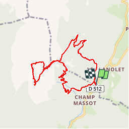
11.1 km | 17.4 km-effort
4h 43min
Yes
Trail Walking Saint-Pierre-d'Entremont - Le Grand Som 2026m, depuis Saint-Philibert - Photo
Walking
tracegps

Walking

Difficult
(1)
Saint-Pierre-d'Entremont, Auvergne-Rhône-Alpes, Isère, France
11.2 km | 25 km-effort
7h 0min
Yes
Trail Walking Saint-Pierre-de-Chartreuse - Les haberts du Désert de Chartreuse - Photo
Walking
tracegps

Walking

Medium
(1)
Saint-Pierre-de-Chartreuse, Auvergne-Rhône-Alpes, Isère, France
10.9 km | 21 km-effort
5h 0min
Yes
Trail Walking Saint-Christophe-sur-Guiers - Petit Som 1772m,  depuis La Ruchère - Photo
Walking
tracegps

Walking

Medium
(2)
Saint-Christophe-sur-Guiers, Auvergne-Rhône-Alpes, Isère, France
6 km | 13.2 km-effort
3h 30min
Yes
Trail Walking Saint-Christophe-sur-Guiers - 38 grand som par sente intermediaire - Photo
Walking
GUIDE
randodyssée

Walking

Medium
Saint-Christophe-sur-Guiers, Auvergne-Rhône-Alpes, Isère, France
14.5 km | 28 km-effort
7h 11min
Yes
Trail Walking Saint-Pierre-de-Chartreuse - pas de rochebrune et de rocheplane  - Photo
Walking
GUIDE
nadd73

Walking

Difficult
Saint-Pierre-de-Chartreuse, Auvergne-Rhône-Alpes, Isère, France
13.2 km | 26 km-effort
5h 32min
Yes
Trail Walking Saint-Pierre-de-Chartreuse - tour de la Dent de crolles par des sangles  - Photo
Walking
GUIDE
nadd73

Walking

Very difficult
Saint-Pierre-de-Chartreuse, Auvergne-Rhône-Alpes, Isère, France
18.3 km | 38 km-effort
7h 35min
Yes
Trail Touring skiing Saint-Christophe-sur-Guiers - Col de mauvernay, de Bovinant, du Frêt et Petit Som - Photo
Touring skiing
GUIDE
nadd73

Touring skiing

Medium
Saint-Christophe-sur-Guiers, Auvergne-Rhône-Alpes, Isère, France
12 km | 29 km-effort
6h 2min
Yes
Trail Walking Saint-Pierre-de-Chartreuse - Dent de Crolles depuis Perquelin  - Photo
Walking
patpounet73

Walking

Difficult
(1)
Saint-Pierre-de-Chartreuse, Auvergne-Rhône-Alpes, Isère, France
12.7 km | 28 km-effort
6h 19min
Yes


Close
My subscriptions