![](/images/other/stat-length.png)
![Trail Walking Mérens-les-Vals - Pic de Canals - Photo](https://media.geolcdn.com/t/1900/400/c8c92fc2-dcb2-4400-9d3c-800f4744a213.jpg&format=pjpeg&maxdim=2)
Pic de Canals
c.chehere
User
![Length](/images/other/stat-length.png)
![Max alt](https://static1.geolcdn.com/siteimages/upload/files/1508320355ic_sort_altitude_max_24dp.png)
![Uphill gradient](https://static1.geolcdn.com/siteimages/upload/files/1508320355ic_sort_den_pos_24dp.png)
![Km-Effort](/images/other/stat-length.png)
![Min alt](https://static1.geolcdn.com/siteimages/upload/files/1508320355ic_sort_altitude_min_24dp.png)
![Downhill gradient](https://static1.geolcdn.com/siteimages/upload/files/1508320355ic_sort_den_neg_24dp.png)
![Boucle](https://static1.geolcdn.com/siteimages/upload/files/16400158638029165_repeat_loop_refresh_sync_direction_icon.png)
![Walking](https://static1.geolcdn.com/sitytour/trail-icons/101.png)
8h27
Difficulty : Difficult
![Scan this QR Code to open this trail in the SityTrail application](https://capi.geolives.com/qq0zvz2zws4bq2lad0pu/sitytour/trails/2011599/qr.png?size=200)
FREE GPS app for hiking
About
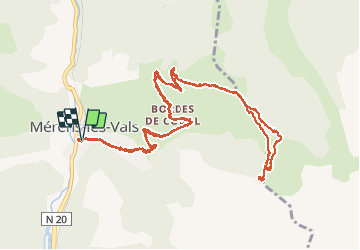
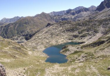
Trail Walking of 16.7 km to be discovered at Occitania, Ariège, Mérens-les-Vals. This trail is proposed by c.chehere.
Description
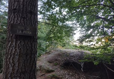
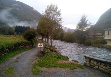
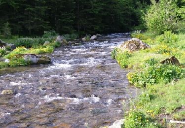
Depuis la gare SNCF de Mérens les vals, prendre le GR 10 puis le GR 107.
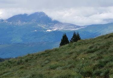
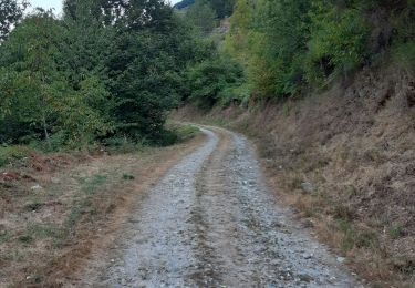
Monter par de bons sentiers jusqu'à croiser une piste forestiere (panneau de randonnées). Prendre celle-ci sur le droite et aller jusqu'au col De Surle. Monter en direction du Sud/est en suivant la crète. Par un bon sentier parfois raide arriver au sommet où la vue est simplement sublime.
Revenir à Mérens par le même chemin.
Positioning
Comments
Trails nearby
![Trail Walking Orgeix - aiguelongue - Photo](https://media.geolcdn.com/t/375/260/ext.jpg?maxdim=2&url=https%3A%2F%2Fservices.sitytrail.com%2FGeolivesWS%2FDownloadMedia.ashx%3FTrailID%3D643989%26Media%3Dfix__20161010104856.jpg)
![Walking Walking](https://static1.geolcdn.com/sitytour/trail-icons/101.png)
![Trail Walking Mérens-les-Vals - Etang de Comte - Merens les Vals - Photo](https://media.geolcdn.com/t/375/260/ext.jpg?maxdim=2&url=https%3A%2F%2Fservices.sitytrail.com%2FGeolivesWS%2FDownloadMedia.ashx%3FTrailID%3D104799%26Media%3D8276_1.jpg)
![Walking Walking](https://static1.geolcdn.com/sitytour/trail-icons/101.png)
Walking
![](/images/other/stat-length.png)
![](https://static1.geolcdn.com/siteimages/upload/files/16400158638029165_repeat_loop_refresh_sync_direction_icon.png)
![Trail Walking Orlu - Le Fanguil - Photo](https://media.geolcdn.com/t/375/260/c3accd76-1509-4827-a01c-0e33052ccaa5.jpg&format=jpg&maxdim=2)
![Walking Walking](https://static1.geolcdn.com/sitytour/trail-icons/101.png)
![Trail Walking Orlu - Le roc de la péra - Photo](https://media.geolcdn.com/t/375/260/73155c20-8e48-42b7-9201-111106b56065.jpg&format=jpg&maxdim=2)
![Walking Walking](https://static1.geolcdn.com/sitytour/trail-icons/101.png)
Walking
![](/images/other/stat-length.png)
![](https://static1.geolcdn.com/siteimages/upload/files/16400158638029165_repeat_loop_refresh_sync_direction_icon.png)
![Trail Walking Mérens-les-Vals - Pic de canals en boucle - Photo](https://media.geolcdn.com/t/375/260/57bc1271-5a5a-4949-81ec-e2fba4899a43.jpg&format=jpg&maxdim=2)
![Walking Walking](https://static1.geolcdn.com/sitytour/trail-icons/101.png)
Walking
![](/images/other/stat-length.png)
![](https://static1.geolcdn.com/siteimages/upload/files/16400158638029165_repeat_loop_refresh_sync_direction_icon.png)
![Trail Nordic walking Orlu - Orlu, col de l'Osque, Porteille d'Orgeix, Orgeix - Photo](https://media.geolcdn.com/t/375/260/bb96309c-1ffe-4fdf-ba7a-51865c84fc15.jpg&format=jpg&maxdim=2)
![Nordic walking Nordic walking](https://static1.geolcdn.com/sitytour/trail-icons/102.png)
Nordic walking
![](/images/other/stat-length.png)
![](https://static1.geolcdn.com/siteimages/upload/files/16400158638029165_repeat_loop_refresh_sync_direction_icon.png)
![Trail Walking Orlu - LaLiau - Photo](https://media.geolcdn.com/t/375/260/a1553a6f-6a25-457e-a62d-a8e503e31d85.jpg&format=jpg&maxdim=2)
![Walking Walking](https://static1.geolcdn.com/sitytour/trail-icons/101.png)
![Trail Walking Orgeix - Pic de l'homme par les crêtes - Photo](https://media.geolcdn.com/t/375/260/ext.jpg?maxdim=2&url=https%3A%2F%2Fservices.sitytrail.com%2FGeolivesWS%2FDownloadMedia.ashx%3FTrailID%3D815731%26Media%3D50b6cd61-3adc-46d0-8ebf-fb8b362ce67b.JPG)
![Walking Walking](https://static1.geolcdn.com/sitytour/trail-icons/101.png)
Walking
![](/images/other/stat-length.png)
![](https://static1.geolcdn.com/siteimages/upload/files/16400158638029165_repeat_loop_refresh_sync_direction_icon.png)
![Trail Walking Mérens-les-Vals - le lac Couart - Photo](https://media.geolcdn.com/t/375/260/ext.jpg?maxdim=2&url=https%3A%2F%2Fservices.sitytrail.com%2FGeolivesWS%2FDownloadMedia.ashx%3FTrailID%3D315324%26Media%3Dfix__20140622084804.jpg)
![Walking Walking](https://static1.geolcdn.com/sitytour/trail-icons/101.png)
Walking
![](/images/other/stat-length.png)
![](https://static1.geolcdn.com/siteimages/upload/files/16400158638029165_repeat_loop_refresh_sync_direction_icon.png)