Trail Walking Saint-Amand-les-Eaux - Ballade sur le sentier des Sangliers - Photo

Ballade sur le sentier des Sangliers

© OpenStreetMap contributors
Length
Length
17.1 km
Max alt
Max alt
39 m
Uphill gradient
Uphill gradient
94 m
Km-Effort
Km-Effort  
18.4 km
Min alt
Min alt
13 m
Downhill gradient
Downhill gradient
100 m
Boucle
Boucle
No
Creation date :
2018-09-24 17:12:48.473
Updated on :
2018-09-24 19:21:28.902

(0 Reviews)

Walking
Walking
2h07
Difficulty : Difficult

Scan this QR Code to open this trail in the SityTrail application

FREE GPS app for hiking

Logo SityTrail SityTrail

IGN / Geographical institutes

Download SityTrail from the App Store Download SityTrail from Google Play

Logo SityTrail SityTrail World

The world is yours!

Download SityTrail from the App Store Download SityTrail from Google Play Download SityTrail on Huawei AppGallery

About

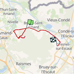
Trail Walking of 17.1 km to be discovered at Hauts-de-France, Nord, Saint-Amand-les-Eaux. This trail is proposed by Pascal Catenne.

Description

Le nom donné à cette randonnée vient du fait qu'au niveau du demi tour ma chienne et moi sommes tombé sur une harde de sangliers qui nous ont non seulement coupé le retour, obligé à faire demi tour mais en plus nous suivaient. D'ou le détour par le village et la grand route pour rejoindre la voiture ainsi que la moyenne de marche : 7,5 au lieu des 5,4 km/h habituel. Je déconseille cette balade le soir par contre je referais le tracé de jour.

Elevation profile

Photos

Positioning

Country:
France
Region :
Hauts-de-France
Department/Province :
Nord
Municipality :
Saint-Amand-les-Eaux
Location:
Unknown
Start:(UTM)
534827 ; 5589780 (31U) N.

Trails nearby

Trail Walking Hergnies - Entre terre et eaux - Hergnies - Photo
Walking
tracegps

Walking

Difficult
(2)
Hergnies, Hauts-de-France, Nord, France
13.2 km | 13.9 km-effort
3h 19min
Yes
Trail Walking Mortagne-du-Nord - Mortagne-du-Nord 18,6 km - Photo
Walking
GUIDE
rvapeldo

Walking

Mortagne-du-Nord, Hauts-de-France, Nord, France
18.6 km | 20 km-effort
4h 20min
Yes
Trail Walking Saint-Amand-les-Eaux - terril vicoigne - Photo
Walking
papiou

Walking

Easy
(1)
Saint-Amand-les-Eaux, Hauts-de-France, Nord, France
8.7 km | 9.7 km-effort
2h 0min
Yes
Trail Walking Saint-Amand-les-Eaux - notre dame d'amour(NDA), propose par VDN - Photo
Walking
papiou

Walking

Medium
Saint-Amand-les-Eaux, Hauts-de-France, Nord, France
9.7 km | 10.6 km-effort
2h 16min
Yes
Trail Walking Nivelle - Nivelle- circuit Nivelle-Mortagne-Chateau l'abbaye - Photo
Walking
papiou

Walking

Easy
(1)
Nivelle, Hauts-de-France, Nord, France
11.5 km | 12.2 km-effort
2h 30min
Yes
Trail Walking Château-l'Abbaye - château l'abbaye. entre Escaut et Scarpe - Photo
Walking
papiou

Walking

Medium
Château-l'Abbaye, Hauts-de-France, Nord, France
8 km | 8.4 km-effort
1h 27min
Yes
Trail Walking Saint-Amand-les-Eaux - Mesnil, version plus longue - Photo
Walking
papiou

Walking

Easy
Saint-Amand-les-Eaux, Hauts-de-France, Nord, France
9.9 km | 11.1 km-effort
2h 2min
Yes
Trail Walking Saint-Amand-les-Eaux - Mesnil. st Amand - Photo
Walking
papiou

Walking

Easy
Saint-Amand-les-Eaux, Hauts-de-France, Nord, France
8.5 km | 9.6 km-effort
1h 28min
Yes
Trail Walking Nivelle - le tour de Nivelle par Thun et écluses de Mortagne - Photo
Walking
papiou

Walking

Easy
Nivelle, Hauts-de-France, Nord, France
10.5 km | 11.1 km-effort
2h 0min
Yes


Close
My subscriptions