![](/images/other/stat-length.png)
![Trail Walking Aulhat-Flat - Flat_Bacs_Chanvre - Photo](https://media.geolcdn.com/t/1900/400/6faf2111-cdba-475e-83d8-5ac5c65b639c.jpg&format=pjpeg&maxdim=2)
Flat_Bacs_Chanvre
jagarnier
User GUIDE
![Length](/images/other/stat-length.png)
Length
7.7 km
![Max alt](https://static1.geolcdn.com/siteimages/upload/files/1508320355ic_sort_altitude_max_24dp.png)
Max alt
569 m
![Uphill gradient](https://static1.geolcdn.com/siteimages/upload/files/1508320355ic_sort_den_pos_24dp.png)
Uphill gradient
206 m
![Km-Effort](/images/other/stat-length.png)
Km-Effort
10.5 km
![Min alt](https://static1.geolcdn.com/siteimages/upload/files/1508320355ic_sort_altitude_min_24dp.png)
Min alt
418 m
![Downhill gradient](https://static1.geolcdn.com/siteimages/upload/files/1508320355ic_sort_den_neg_24dp.png)
Downhill gradient
206 m
![Boucle](https://static1.geolcdn.com/siteimages/upload/files/16400158638029165_repeat_loop_refresh_sync_direction_icon.png)
Boucle
Yes
Creation date :
2018-09-22 06:13:44.416
Updated on :
2023-10-09 10:00:24.348
![Walking](https://static1.geolcdn.com/sitytour/trail-icons/101.png)
2h15
Difficulty : Easy
![Scan this QR Code to open this trail in the SityTrail application](https://capi.geolives.com/qq0zvz2zws4bq2lad0pu/sitytour/trails/2010854/qr.png?size=200)
FREE GPS app for hiking
About
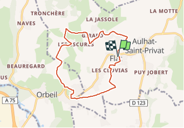
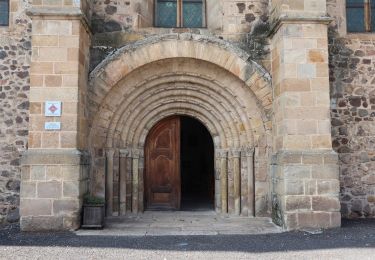
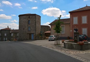
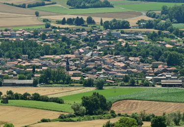
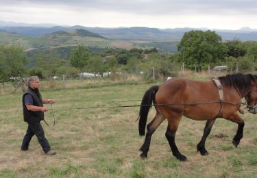
Trail Walking of 7.7 km to be discovered at Auvergne-Rhône-Alpes, Puy-de-Dôme, Aulhat-Flat. This trail is proposed by jagarnier.
Description
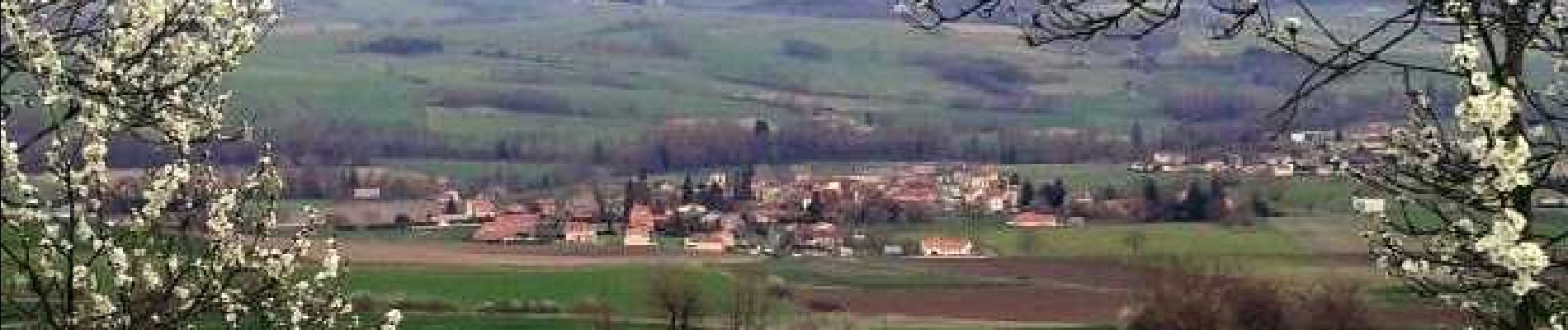
Une randonnée sur le thème du patrimoine relié à l'eau et une sensibilisation sur un patrimoine et des valeurs perdues. Les bacs à chanvre témoignent d'une activité agricole qui offrait une véritable plus-value à ses habitants.
Positioning
Country:
France
Region :
Auvergne-Rhône-Alpes
Department/Province :
Puy-de-Dôme
Municipality :
Aulhat-Flat
Location:
Unknown
Start:(Dec)
Start:(UTM)
523670 ; 5046389 (31T) N.
Comments
Trails nearby
![Trail Motor Issoire - monboissiers 2 - Photo](https://media.geolcdn.com/t/375/260/ext.jpg?maxdim=2&url=https%3A%2F%2Fservices.sitytrail.com%2FGeolivesWS%2FDownloadMedia.ashx%3FTrailID%3D987209%26Media%3Dfix__20171022103942.jpg)
![Motor Motor](https://static1.geolcdn.com/sitytour/trail-icons/400.png)
monboissiers 2
Motor
Medium
(1)
Issoire,
Auvergne-Rhône-Alpes,
Puy-de-Dôme,
France
![](/images/other/stat-length.png)
101 km | 129 km-effort
3h 0min
![](https://static1.geolcdn.com/siteimages/upload/files/16400158638029165_repeat_loop_refresh_sync_direction_icon.png)
Yes
![Trail Walking Brenat - Brenat_Tour_Gevillat - Photo](https://media.geolcdn.com/t/375/260/2b9dba0d-44c9-4336-a13d-50587f665150.jpg&format=jpg&maxdim=2)
![Walking Walking](https://static1.geolcdn.com/sitytour/trail-icons/101.png)
Brenat_Tour_Gevillat
Walking
Easy
(1)
Brenat,
Auvergne-Rhône-Alpes,
Puy-de-Dôme,
France
![](/images/other/stat-length.png)
9.3 km | 11.9 km-effort
2h 45min
![](https://static1.geolcdn.com/siteimages/upload/files/16400158638029165_repeat_loop_refresh_sync_direction_icon.png)
Yes
![Trail On foot Manglieu - Le Puy de Ceveloux - Photo](https://media.geolcdn.com/t/375/260/c5127649-bac8-4e49-a988-ae2fa25c3ccb.jpeg&format=jpg&maxdim=2)
![On foot On foot](https://static1.geolcdn.com/sitytour/trail-icons/100.png)
Le Puy de Ceveloux
On foot
Easy
Manglieu,
Auvergne-Rhône-Alpes,
Puy-de-Dôme,
France
![](/images/other/stat-length.png)
8.6 km | 10.8 km-effort
2h 27min
![](https://static1.geolcdn.com/siteimages/upload/files/16400158638029165_repeat_loop_refresh_sync_direction_icon.png)
No
![Trail On foot Yronde-et-Buron - L'Abbaye du Bouschet - Photo](https://media.geolcdn.com/t/375/260/50cfacdd-f92e-4973-88f2-43faafdab62f.jpeg&format=jpg&maxdim=2)
![On foot On foot](https://static1.geolcdn.com/sitytour/trail-icons/100.png)
L'Abbaye du Bouschet
On foot
Easy
Yronde-et-Buron,
Auvergne-Rhône-Alpes,
Puy-de-Dôme,
France
![](/images/other/stat-length.png)
10.8 km | 14.8 km-effort
3h 21min
![](https://static1.geolcdn.com/siteimages/upload/files/16400158638029165_repeat_loop_refresh_sync_direction_icon.png)
Yes
![Trail On foot Aulhat-Flat - De fontaines en lavoirs - Photo](https://media.geolcdn.com/t/375/260/703b4131-777a-4c7d-8202-8509fe28e70b.jpeg&format=jpg&maxdim=2)
![On foot On foot](https://static1.geolcdn.com/sitytour/trail-icons/100.png)
De fontaines en lavoirs
On foot
Medium
Aulhat-Flat,
Auvergne-Rhône-Alpes,
Puy-de-Dôme,
France
![](/images/other/stat-length.png)
14.7 km | 21 km-effort
4h 51min
![](https://static1.geolcdn.com/siteimages/upload/files/16400158638029165_repeat_loop_refresh_sync_direction_icon.png)
Yes
![Trail On foot Usson - Le Pic d'Usson - Photo](https://media.geolcdn.com/t/375/260/6a96298d-c1d0-4fd4-b2cd-7460048c5b43.jpeg&format=jpg&maxdim=2)
![On foot On foot](https://static1.geolcdn.com/sitytour/trail-icons/100.png)
Le Pic d'Usson
On foot
Easy
Usson,
Auvergne-Rhône-Alpes,
Puy-de-Dôme,
France
![](/images/other/stat-length.png)
7.7 km | 9.6 km-effort
2h 11min
![](https://static1.geolcdn.com/siteimages/upload/files/16400158638029165_repeat_loop_refresh_sync_direction_icon.png)
No
![Trail On foot Brenat - La Tour de Gevillat - Photo](https://media.geolcdn.com/t/375/260/12927b2d-86e8-4e4a-bbac-13d0164d4024.jpeg&format=jpg&maxdim=2)
![On foot On foot](https://static1.geolcdn.com/sitytour/trail-icons/100.png)
La Tour de Gevillat
On foot
Easy
Brenat,
Auvergne-Rhône-Alpes,
Puy-de-Dôme,
France
![](/images/other/stat-length.png)
9.8 km | 12.6 km-effort
2h 52min
![](https://static1.geolcdn.com/siteimages/upload/files/16400158638029165_repeat_loop_refresh_sync_direction_icon.png)
Yes
![Trail On foot Orbeil - Le Domaine de Vort - Photo](https://media.geolcdn.com/t/375/260/a71f37d1-3970-4753-9b87-52398d6f3c62.jpeg&format=jpg&maxdim=2)
![On foot On foot](https://static1.geolcdn.com/sitytour/trail-icons/100.png)
Le Domaine de Vort
On foot
Easy
Orbeil,
Auvergne-Rhône-Alpes,
Puy-de-Dôme,
France
![](/images/other/stat-length.png)
8.8 km | 12.1 km-effort
2h 45min
![](https://static1.geolcdn.com/siteimages/upload/files/16400158638029165_repeat_loop_refresh_sync_direction_icon.png)
Yes
![Trail Walking Yronde-et-Buron - Foncrepon_Puy_Moriot - Photo](https://media.geolcdn.com/t/375/260/7a50da42-4be5-4d88-b81e-5c29e8aa1bd9.jpg&format=jpg&maxdim=2)
![Walking Walking](https://static1.geolcdn.com/sitytour/trail-icons/101.png)
Foncrepon_Puy_Moriot
Walking
Medium
Yronde-et-Buron,
Auvergne-Rhône-Alpes,
Puy-de-Dôme,
France
![](/images/other/stat-length.png)
10.5 km | 15.2 km-effort
3h 0min
![](https://static1.geolcdn.com/siteimages/upload/files/16400158638029165_repeat_loop_refresh_sync_direction_icon.png)
Yes