![](/images/other/stat-length.png)
![Trail Walking Courpière - Courpiere_Courtesserre - Photo](https://media.geolcdn.com/t/1900/400/374f1faa-e125-4b45-914f-a9adb07813a8.jpg&format=pjpeg&maxdim=2)
Courpiere_Courtesserre
jagarnier
User GUIDE
![Length](/images/other/stat-length.png)
Length
9.7 km
![Max alt](https://static1.geolcdn.com/siteimages/upload/files/1508320355ic_sort_altitude_max_24dp.png)
Max alt
485 m
![Uphill gradient](https://static1.geolcdn.com/siteimages/upload/files/1508320355ic_sort_den_pos_24dp.png)
Uphill gradient
235 m
![Km-Effort](/images/other/stat-length.png)
Km-Effort
12.8 km
![Min alt](https://static1.geolcdn.com/siteimages/upload/files/1508320355ic_sort_altitude_min_24dp.png)
Min alt
331 m
![Downhill gradient](https://static1.geolcdn.com/siteimages/upload/files/1508320355ic_sort_den_neg_24dp.png)
Downhill gradient
235 m
![Boucle](https://static1.geolcdn.com/siteimages/upload/files/16400158638029165_repeat_loop_refresh_sync_direction_icon.png)
Boucle
Yes
Creation date :
2018-09-13 06:38:28.594
Updated on :
2023-03-24 06:51:11.17
![Walking](https://static1.geolcdn.com/sitytour/trail-icons/101.png)
2h45
Difficulty : Medium
![Scan this QR Code to open this trail in the SityTrail application](https://capi.geolives.com/qq0zvz2zws4bq2lad0pu/sitytour/trails/2009972/qr.png?size=200)
FREE GPS app for hiking
About
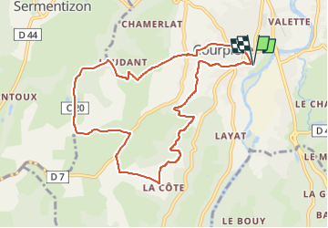
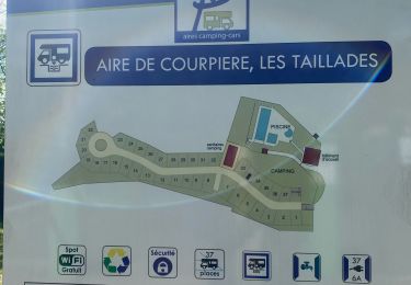
Trail Walking of 9.7 km to be discovered at Auvergne-Rhône-Alpes, Puy-de-Dôme, Courpière. This trail is proposed by jagarnier.
Description
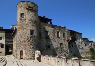
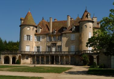
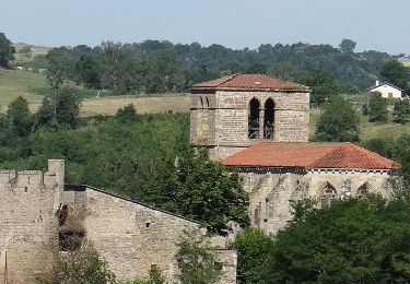
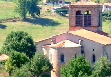
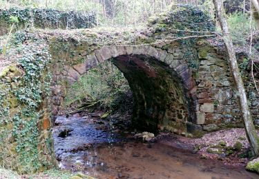
Le circuit progresse en balcon sur la vallée de la Dore jusqu'à Courteserre qui fut le siège d'une commanderie de l'ordre de Malte.
Positioning
Country:
France
Region :
Auvergne-Rhône-Alpes
Department/Province :
Puy-de-Dôme
Municipality :
Courpière
Location:
Unknown
Start:(Dec)
Start:(UTM)
541862 ; 5066840 (31T) N.
Comments
Trails nearby
![Trail Walking Aubusson-d'Auvergne - Aubusson_Lac - Photo](https://media.geolcdn.com/t/375/260/e8789334-900b-4b7b-aeae-be52f5c8b304.jpg&format=jpg&maxdim=2)
![Walking Walking](https://static1.geolcdn.com/sitytour/trail-icons/101.png)
Aubusson_Lac
Walking
Easy
(2)
Aubusson-d'Auvergne,
Auvergne-Rhône-Alpes,
Puy-de-Dôme,
France
![](/images/other/stat-length.png)
11.8 km | 14.6 km-effort
3h 30min
![](https://static1.geolcdn.com/siteimages/upload/files/16400158638029165_repeat_loop_refresh_sync_direction_icon.png)
Yes
![Trail Walking Courpière - Les Taillades près Courpière - Photo](https://media.geolcdn.com/t/375/260/ext.jpg?maxdim=2&url=https%3A%2F%2Fservices.sitytrail.com%2FGeolivesWS%2FDownloadMedia.ashx%3FTrailID%3D105959%26Media%3D10032_1.jpg)
![Walking Walking](https://static1.geolcdn.com/sitytour/trail-icons/101.png)
Les Taillades près Courpière
Walking
Difficult
(1)
Courpière,
Auvergne-Rhône-Alpes,
Puy-de-Dôme,
France
![](/images/other/stat-length.png)
19.9 km | 27 km-effort
5h 0min
![](https://static1.geolcdn.com/siteimages/upload/files/16400158638029165_repeat_loop_refresh_sync_direction_icon.png)
Yes
![Trail On foot Courpière - Les collines de Courtesserre - Photo](https://media.geolcdn.com/t/375/260/aefce04e-c723-452a-b34e-f8f498f04b38.jpeg&format=jpg&maxdim=2)
![On foot On foot](https://static1.geolcdn.com/sitytour/trail-icons/100.png)
Les collines de Courtesserre
On foot
Easy
Courpière,
Auvergne-Rhône-Alpes,
Puy-de-Dôme,
France
![](/images/other/stat-length.png)
9.7 km | 12.8 km-effort
2h 54min
![](https://static1.geolcdn.com/siteimages/upload/files/16400158638029165_repeat_loop_refresh_sync_direction_icon.png)
Yes
![Trail Walking Aubusson-d'Auvergne - Courpiere_Salet - Photo](https://media.geolcdn.com/t/375/260/bbf55bae-e8c1-4a54-bc8e-1404647a3e82.jpg&format=jpg&maxdim=2)
![Walking Walking](https://static1.geolcdn.com/sitytour/trail-icons/101.png)
Courpiere_Salet
Walking
Medium
(1)
Aubusson-d'Auvergne,
Auvergne-Rhône-Alpes,
Puy-de-Dôme,
France
![](/images/other/stat-length.png)
11.1 km | 15 km-effort
3h 15min
![](https://static1.geolcdn.com/siteimages/upload/files/16400158638029165_repeat_loop_refresh_sync_direction_icon.png)
Yes
![Trail Walking Sauviat - Sauviat_Plateau - Photo](https://media.geolcdn.com/t/375/260/cd996071-3cf8-4532-b078-fc961fa9d701.jpg&format=jpg&maxdim=2)
![Walking Walking](https://static1.geolcdn.com/sitytour/trail-icons/101.png)
Sauviat_Plateau
Walking
Medium
Sauviat,
Auvergne-Rhône-Alpes,
Puy-de-Dôme,
France
![](/images/other/stat-length.png)
13.4 km | 17.3 km-effort
4h 0min
![](https://static1.geolcdn.com/siteimages/upload/files/16400158638029165_repeat_loop_refresh_sync_direction_icon.png)
Yes
![Trail Walking Saint-Flour-l'Étang - St_Flour_Etang_Isle_Dore - Photo](https://media.geolcdn.com/t/375/260/60312493-d97e-4991-b835-b3b51085f67d.jpg&format=jpg&maxdim=2)
![Walking Walking](https://static1.geolcdn.com/sitytour/trail-icons/101.png)
St_Flour_Etang_Isle_Dore
Walking
Medium
Saint-Flour-l'Étang,
Auvergne-Rhône-Alpes,
Puy-de-Dôme,
France
![](/images/other/stat-length.png)
10.3 km | 14.5 km-effort
3h 0min
![](https://static1.geolcdn.com/siteimages/upload/files/16400158638029165_repeat_loop_refresh_sync_direction_icon.png)
Yes
![Trail Walking Sermentizon - Sermentizon_Chemin_Lilion - Photo](https://media.geolcdn.com/t/375/260/48f59c3d-f2d8-453c-8af8-daf03a73e35d.jpg&format=jpg&maxdim=2)
![Walking Walking](https://static1.geolcdn.com/sitytour/trail-icons/101.png)
Sermentizon_Chemin_Lilion
Walking
Medium
Sermentizon,
Auvergne-Rhône-Alpes,
Puy-de-Dôme,
France
![](/images/other/stat-length.png)
13.3 km | 18.7 km-effort
4h 1min
![](https://static1.geolcdn.com/siteimages/upload/files/16400158638029165_repeat_loop_refresh_sync_direction_icon.png)
Yes
![Trail sport Courpière - COURPIERE Auvergne - Photo](https://media.geolcdn.com/t/375/260/998a6c45-edc4-4a49-93a0-d1f6173e4780.jpg&format=jpg&maxdim=2)
COURPIERE Auvergne
sport
Very easy
Courpière,
Auvergne-Rhône-Alpes,
Puy-de-Dôme,
France
![](/images/other/stat-length.png)
7.5 km | 8.4 km-effort
Unknown
![](https://static1.geolcdn.com/siteimages/upload/files/16400158638029165_repeat_loop_refresh_sync_direction_icon.png)
No
![Trail Walking Aubusson-d'Auvergne - Les quatre vents Aubusson 1er jour - Photo](https://media.geolcdn.com/t/375/260/76dd7eb9-eaaa-4c14-b581-8d417a1c9807.jpg&format=jpg&maxdim=2)
![Walking Walking](https://static1.geolcdn.com/sitytour/trail-icons/101.png)
Les quatre vents Aubusson 1er jour
Walking
Medium
Aubusson-d'Auvergne,
Auvergne-Rhône-Alpes,
Puy-de-Dôme,
France
![](/images/other/stat-length.png)
18 km | 23 km-effort
6h 38min
![](https://static1.geolcdn.com/siteimages/upload/files/16400158638029165_repeat_loop_refresh_sync_direction_icon.png)
Yes