![](/images/other/stat-length.png)
![Trail Mountain bike La Plagne-Tarentaise - VTT E - Photo](https://media.geolcdn.com/t/1900/400/ext.pjpeg?maxdim=2&url=https%3A%2F%2Fstatic1.geolcdn.com%2Fsiteimages%2Fupload%2Ffiles%2F1524743154velo.jpg)
VTT E
antoine.vacher
User
![Length](/images/other/stat-length.png)
Length
24 km
![Max alt](https://static1.geolcdn.com/siteimages/upload/files/1508320355ic_sort_altitude_max_24dp.png)
Max alt
2613 m
![Uphill gradient](https://static1.geolcdn.com/siteimages/upload/files/1508320355ic_sort_den_pos_24dp.png)
Uphill gradient
1157 m
![Km-Effort](/images/other/stat-length.png)
Km-Effort
40 km
![Min alt](https://static1.geolcdn.com/siteimages/upload/files/1508320355ic_sort_altitude_min_24dp.png)
Min alt
1837 m
![Downhill gradient](https://static1.geolcdn.com/siteimages/upload/files/1508320355ic_sort_den_neg_24dp.png)
Downhill gradient
1299 m
![Boucle](https://static1.geolcdn.com/siteimages/upload/files/16400158638029165_repeat_loop_refresh_sync_direction_icon.png)
Boucle
No
Creation date :
2018-08-07 06:46:06.98
Updated on :
2018-08-07 15:13:08.294
![Mountain bike](https://static1.geolcdn.com/sitytour/trail-icons/202.png)
2h59
Difficulty : Medium
![Scan this QR Code to open this trail in the SityTrail application](https://capi.geolives.com/qq0zvz2zws4bq2lad0pu/sitytour/trails/2005712/qr.png?size=200)
FREE GPS app for hiking
About
Trail Mountain bike of 24 km to be discovered at Auvergne-Rhône-Alpes, Savoy, La Plagne-Tarentaise. This trail is proposed by antoine.vacher.
Description
Tour de VTT électrique, combinant la roche de mio et le tour du saint Jacques, niveau "rouge" surtout le parcours autour du saint Jacques
Positioning
Country:
France
Region :
Auvergne-Rhône-Alpes
Department/Province :
Savoy
Municipality :
La Plagne-Tarentaise
Location:
Mâcot-la-Plagne
Start:(Dec)
Start:(UTM)
319378 ; 5041558 (32T) N.
Comments
Trails nearby
![Trail On foot Aime-la-Plagne - Le Mont Jovet - Photo](https://media.geolcdn.com/t/375/260/e03d3a37-c792-4b26-aee8-eb362e80dc2f.jpeg&format=jpg&maxdim=2)
![On foot On foot](https://static1.geolcdn.com/sitytour/trail-icons/100.png)
Le Mont Jovet
On foot
Medium
Aime-la-Plagne,
Auvergne-Rhône-Alpes,
Savoy,
France
![](/images/other/stat-length.png)
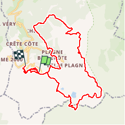
11.1 km | 21 km-effort
4h 45min
![](https://static1.geolcdn.com/siteimages/upload/files/16400158638029165_repeat_loop_refresh_sync_direction_icon.png)
Yes
![Trail On foot La Plagne-Tarentaise - Les Frasses - Photo](https://media.geolcdn.com/t/375/260/57e5726a-4c56-4000-a6b5-c37a4dc312d4.jpeg&format=jpg&maxdim=2)
![On foot On foot](https://static1.geolcdn.com/sitytour/trail-icons/100.png)
Les Frasses
On foot
Easy
La Plagne-Tarentaise,
Auvergne-Rhône-Alpes,
Savoy,
France
![](/images/other/stat-length.png)
5.7 km | 7.8 km-effort
1h 45min
![](https://static1.geolcdn.com/siteimages/upload/files/16400158638029165_repeat_loop_refresh_sync_direction_icon.png)
No
![Trail On foot La Plagne-Tarentaise - Boucle du Carroley - Photo](https://media.geolcdn.com/t/375/260/3845229a-3558-42f8-bdc8-ddfb57759bc2.jpeg&format=jpg&maxdim=2)
![On foot On foot](https://static1.geolcdn.com/sitytour/trail-icons/100.png)
Boucle du Carroley
On foot
Easy
La Plagne-Tarentaise,
Auvergne-Rhône-Alpes,
Savoy,
France
![](/images/other/stat-length.png)
4.2 km | 7.5 km-effort
1h 41min
![](https://static1.geolcdn.com/siteimages/upload/files/16400158638029165_repeat_loop_refresh_sync_direction_icon.png)
No
![Trail On foot La Plagne-Tarentaise - Sentier Découverte Grande Rochette - Photo](https://media.geolcdn.com/t/375/260/6702af47-efb8-435e-b569-0f7bde146ef0.jpeg&format=jpg&maxdim=2)
![On foot On foot](https://static1.geolcdn.com/sitytour/trail-icons/100.png)
Sentier Découverte Grande Rochette
On foot
Easy
La Plagne-Tarentaise,
Auvergne-Rhône-Alpes,
Savoy,
France
![](/images/other/stat-length.png)
9.2 km | 16.3 km-effort
3h 42min
![](https://static1.geolcdn.com/siteimages/upload/files/16400158638029165_repeat_loop_refresh_sync_direction_icon.png)
Yes
![Trail On foot La Plagne-Tarentaise - Boucle de Roche de Mio - Photo](https://media.geolcdn.com/t/375/260/a45fc0d9-32f7-44a2-8151-cf7ff4393f59.jpeg&format=jpg&maxdim=2)
![On foot On foot](https://static1.geolcdn.com/sitytour/trail-icons/100.png)
Boucle de Roche de Mio
On foot
Easy
La Plagne-Tarentaise,
Auvergne-Rhône-Alpes,
Savoy,
France
![](/images/other/stat-length.png)
5.6 km | 12.1 km-effort
2h 44min
![](https://static1.geolcdn.com/siteimages/upload/files/16400158638029165_repeat_loop_refresh_sync_direction_icon.png)
No
![Trail On foot Aime-la-Plagne - Route Balcon - Photo](https://media.geolcdn.com/t/375/260/29321373-2636-40af-bbf6-92b2143917ee.jpeg&format=jpg&maxdim=2)
![On foot On foot](https://static1.geolcdn.com/sitytour/trail-icons/100.png)
Route Balcon
On foot
Easy
Aime-la-Plagne,
Auvergne-Rhône-Alpes,
Savoy,
France
![](/images/other/stat-length.png)
7.4 km | 9.6 km-effort
2h 11min
![](https://static1.geolcdn.com/siteimages/upload/files/16400158638029165_repeat_loop_refresh_sync_direction_icon.png)
No
![Trail On foot La Plagne-Tarentaise - Le Lac Vert - Photo](https://media.geolcdn.com/t/375/260/b6f38b54-08a4-411e-90a2-00a3af0c38ce.jpeg&format=jpg&maxdim=2)
![On foot On foot](https://static1.geolcdn.com/sitytour/trail-icons/100.png)
Le Lac Vert
On foot
Easy
La Plagne-Tarentaise,
Auvergne-Rhône-Alpes,
Savoy,
France
![](/images/other/stat-length.png)
4.6 km | 7 km-effort
1h 36min
![](https://static1.geolcdn.com/siteimages/upload/files/16400158638029165_repeat_loop_refresh_sync_direction_icon.png)
Yes
![Trail Walking Bozel - Le Mont Jovet - Bozel - Photo](https://media.geolcdn.com/t/375/260/ext.jpg?maxdim=2&url=https%3A%2F%2Fstatic1.geolcdn.com%2Fsiteimages%2Fupload%2Ffiles%2F1553511878bg_sport_marche.png)
![Walking Walking](https://static1.geolcdn.com/sitytour/trail-icons/101.png)
Le Mont Jovet - Bozel
Walking
Difficult
(1)
Bozel,
Auvergne-Rhône-Alpes,
Savoy,
France
![](/images/other/stat-length.png)
17.3 km | 32 km-effort
4h 45min
![](https://static1.geolcdn.com/siteimages/upload/files/16400158638029165_repeat_loop_refresh_sync_direction_icon.png)
Yes
![Trail Walking La Plagne-Tarentaise - Plagne Soleil, La Grande Rochette, Plagne Centre - Photo](https://media.geolcdn.com/t/375/260/851dc525-0560-4e84-bbaf-2d67171a4f8c.jpg&format=jpg&maxdim=2)
![Walking Walking](https://static1.geolcdn.com/sitytour/trail-icons/101.png)
Plagne Soleil, La Grande Rochette, Plagne Centre
Walking
Difficult
La Plagne-Tarentaise,
Auvergne-Rhône-Alpes,
Savoy,
France
![](/images/other/stat-length.png)
8.6 km | 14.5 km-effort
2h 57min
![](https://static1.geolcdn.com/siteimages/upload/files/16400158638029165_repeat_loop_refresh_sync_direction_icon.png)
No