![](/images/other/stat-length.png)
![Trail Walking Tours-sur-Meymont - Tours_Meymont_Gorges_Dore - Photo](https://media.geolcdn.com/t/1900/400/63fd52ef-9088-4caf-ab22-5e5d95806189.jpg&format=pjpeg&maxdim=2)
Tours_Meymont_Gorges_Dore
jagarnier
User GUIDE
![Length](/images/other/stat-length.png)
Length
9.3 km
![Max alt](https://static1.geolcdn.com/siteimages/upload/files/1508320355ic_sort_altitude_max_24dp.png)
Max alt
631 m
![Uphill gradient](https://static1.geolcdn.com/siteimages/upload/files/1508320355ic_sort_den_pos_24dp.png)
Uphill gradient
283 m
![Km-Effort](/images/other/stat-length.png)
Km-Effort
13.1 km
![Min alt](https://static1.geolcdn.com/siteimages/upload/files/1508320355ic_sort_altitude_min_24dp.png)
Min alt
487 m
![Downhill gradient](https://static1.geolcdn.com/siteimages/upload/files/1508320355ic_sort_den_neg_24dp.png)
Downhill gradient
283 m
![Boucle](https://static1.geolcdn.com/siteimages/upload/files/16400158638029165_repeat_loop_refresh_sync_direction_icon.png)
Boucle
Yes
Creation date :
2018-08-01 14:13:45.682
Updated on :
2023-10-19 05:34:36.888
![Walking](https://static1.geolcdn.com/sitytour/trail-icons/101.png)
2h45
Difficulty : Medium
![Scan this QR Code to open this trail in the SityTrail application](https://capi.geolives.com/qq0zvz2zws4bq2lad0pu/sitytour/trails/2004880/qr.png?size=200)
FREE GPS app for hiking
About
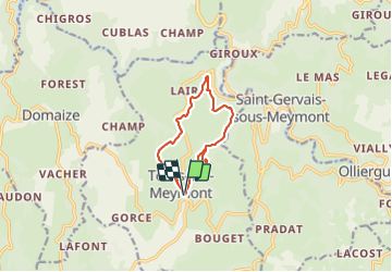
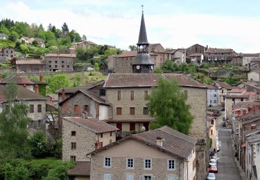
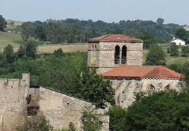
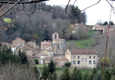
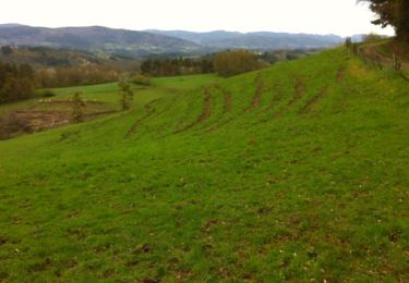
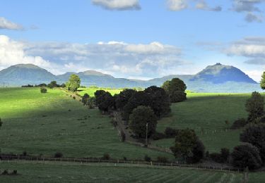
Trail Walking of 9.3 km to be discovered at Auvergne-Rhône-Alpes, Puy-de-Dôme, Tours-sur-Meymont. This trail is proposed by jagarnier.
Description
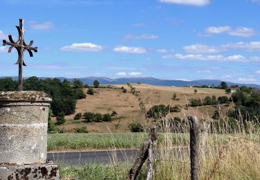
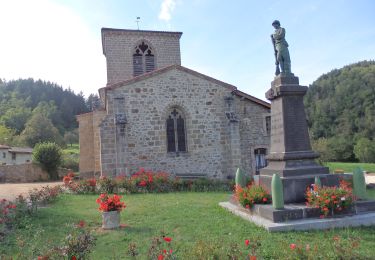
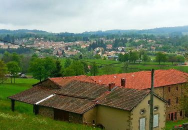
Depuis Tours-sur-Meymont, cette randonnée offre de belles vues sur le vallon des Graves, les gorges de la Dore et les monts du Forez. Vous apprécierez particulièrement, les maisons en pisé, le château privé du Bourgon et le pont en pierre sur le Minchoux.
Positioning
Country:
France
Region :
Auvergne-Rhône-Alpes
Department/Province :
Puy-de-Dôme
Municipality :
Tours-sur-Meymont
Location:
Unknown
Start:(Dec)
Start:(UTM)
544976 ; 5057603 (31T) N.
Comments
Trails nearby
![Trail Walking Domaize - Domaize_Ronde_Fruits - Photo](https://media.geolcdn.com/t/375/260/f4a9ee34-bc35-4d34-92f2-e24618419a1f.jpg&format=jpg&maxdim=2)
![Walking Walking](https://static1.geolcdn.com/sitytour/trail-icons/101.png)
Domaize_Ronde_Fruits
Walking
Medium
(1)
Domaize,
Auvergne-Rhône-Alpes,
Puy-de-Dôme,
France
![](/images/other/stat-length.png)
10.9 km | 15 km-effort
3h 15min
![](https://static1.geolcdn.com/siteimages/upload/files/16400158638029165_repeat_loop_refresh_sync_direction_icon.png)
Yes
![Trail On foot Saint-Gervais-sous-Meymont - Autour de la Maison du Parc - Photo](https://media.geolcdn.com/t/375/260/0cb21de0-a948-4a11-a8b1-73f69021aafa.jpeg&format=jpg&maxdim=2)
![On foot On foot](https://static1.geolcdn.com/sitytour/trail-icons/100.png)
Autour de la Maison du Parc
On foot
Easy
Saint-Gervais-sous-Meymont,
Auvergne-Rhône-Alpes,
Puy-de-Dôme,
France
![](/images/other/stat-length.png)
12.1 km | 18.8 km-effort
4h 16min
![](https://static1.geolcdn.com/siteimages/upload/files/16400158638029165_repeat_loop_refresh_sync_direction_icon.png)
No
![Trail On foot Cunlhat - La Pointe du Jour - Photo](https://media.geolcdn.com/t/375/260/2fa8e53b-b8eb-4d5b-89fc-8615fa6c98ff.jpeg&format=jpg&maxdim=2)
![On foot On foot](https://static1.geolcdn.com/sitytour/trail-icons/100.png)
La Pointe du Jour
On foot
Easy
Cunlhat,
Auvergne-Rhône-Alpes,
Puy-de-Dôme,
France
![](/images/other/stat-length.png)
8.4 km | 11.3 km-effort
2h 33min
![](https://static1.geolcdn.com/siteimages/upload/files/16400158638029165_repeat_loop_refresh_sync_direction_icon.png)
No
![Walking Walking](https://static1.geolcdn.com/sitytour/trail-icons/101.png)
Olliergues_Chabasse
Walking
Medium
Olliergues,
Auvergne-Rhône-Alpes,
Puy-de-Dôme,
France
![](/images/other/stat-length.png)
13.9 km | 20 km-effort
4h 13min
![](https://static1.geolcdn.com/siteimages/upload/files/16400158638029165_repeat_loop_refresh_sync_direction_icon.png)
Yes
![Trail Walking Sauviat - Sauviat_Plateau - Photo](https://media.geolcdn.com/t/375/260/cd996071-3cf8-4532-b078-fc961fa9d701.jpg&format=jpg&maxdim=2)
![Walking Walking](https://static1.geolcdn.com/sitytour/trail-icons/101.png)
Sauviat_Plateau
Walking
Medium
Sauviat,
Auvergne-Rhône-Alpes,
Puy-de-Dôme,
France
![](/images/other/stat-length.png)
13.4 km | 17.3 km-effort
4h 0min
![](https://static1.geolcdn.com/siteimages/upload/files/16400158638029165_repeat_loop_refresh_sync_direction_icon.png)
Yes
![Walking Walking](https://static1.geolcdn.com/sitytour/trail-icons/101.png)
Ceilloux_Bost
Walking
Easy
Ceilloux,
Auvergne-Rhône-Alpes,
Puy-de-Dôme,
France
![](/images/other/stat-length.png)
8.3 km | 11.2 km-effort
2h 30min
![](https://static1.geolcdn.com/siteimages/upload/files/16400158638029165_repeat_loop_refresh_sync_direction_icon.png)
Yes
![Trail Walking Tours-sur-Meymont - De Tours sur Meymont au Moulin du Garret - Photo](https://media.geolcdn.com/t/375/260/ext.jpg?maxdim=2&url=https%3A%2F%2Fservices.sitytrail.com%2FGeolivesWS%2FDownloadMedia.ashx%3FTrailID%3D129777%26Media%3D13320_3.jpg)
![Walking Walking](https://static1.geolcdn.com/sitytour/trail-icons/101.png)
De Tours sur Meymont au Moulin du Garret
Walking
Medium
Tours-sur-Meymont,
Auvergne-Rhône-Alpes,
Puy-de-Dôme,
France
![](/images/other/stat-length.png)
17.4 km | 25 km-effort
5h 0min
![](https://static1.geolcdn.com/siteimages/upload/files/16400158638029165_repeat_loop_refresh_sync_direction_icon.png)
Yes
![Trail Walking La Chapelle-Agnon - Chapelle_Agnon_Pierre_Blanche - Photo](https://media.geolcdn.com/t/375/260/bf721f45-2b95-48ec-8a90-f0651334b4b8.jpg&format=jpg&maxdim=2)
![Walking Walking](https://static1.geolcdn.com/sitytour/trail-icons/101.png)
Chapelle_Agnon_Pierre_Blanche
Walking
Medium
La Chapelle-Agnon,
Auvergne-Rhône-Alpes,
Puy-de-Dôme,
France
![](/images/other/stat-length.png)
9.2 km | 13.1 km-effort
2h 45min
![](https://static1.geolcdn.com/siteimages/upload/files/16400158638029165_repeat_loop_refresh_sync_direction_icon.png)
Yes
![Trail On foot Domaize - La ronde des fruits - Photo](https://media.geolcdn.com/t/375/260/ext.jpg?maxdim=2&url=https%3A%2F%2Fstatic1.geolcdn.com%2Fsiteimages%2Fupload%2Ffiles%2F1545311037marcheuse_200dpi.jpg)
![On foot On foot](https://static1.geolcdn.com/sitytour/trail-icons/100.png)
La ronde des fruits
On foot
Easy
Domaize,
Auvergne-Rhône-Alpes,
Puy-de-Dôme,
France
![](/images/other/stat-length.png)
10.9 km | 15 km-effort
3h 24min
![](https://static1.geolcdn.com/siteimages/upload/files/16400158638029165_repeat_loop_refresh_sync_direction_icon.png)
Yes