![](/images/other/stat-length.png)
![Trail Walking Braine-le-Château - BLChateau 0718 - Photo](https://media.geolcdn.com/t/1900/400/ext.pjpeg?maxdim=2&url=https%3A%2F%2Fstatic1.geolcdn.com%2Fsiteimages%2Fupload%2Ffiles%2F1553511878bg_sport_marche.png)
BLChateau 0718
calofrancis
User
![Length](/images/other/stat-length.png)
Length
9.3 km
![Max alt](https://static1.geolcdn.com/siteimages/upload/files/1508320355ic_sort_altitude_max_24dp.png)
Max alt
143 m
![Uphill gradient](https://static1.geolcdn.com/siteimages/upload/files/1508320355ic_sort_den_pos_24dp.png)
Uphill gradient
155 m
![Km-Effort](/images/other/stat-length.png)
Km-Effort
11.3 km
![Min alt](https://static1.geolcdn.com/siteimages/upload/files/1508320355ic_sort_altitude_min_24dp.png)
Min alt
74 m
![Downhill gradient](https://static1.geolcdn.com/siteimages/upload/files/1508320355ic_sort_den_neg_24dp.png)
Downhill gradient
151 m
![Boucle](https://static1.geolcdn.com/siteimages/upload/files/16400158638029165_repeat_loop_refresh_sync_direction_icon.png)
Boucle
Yes
Creation date :
2018-07-25 15:59:24.051
Updated on :
2018-07-25 16:17:16.331
![Walking](https://static1.geolcdn.com/sitytour/trail-icons/101.png)
2h27
Difficulty : Medium
![Scan this QR Code to open this trail in the SityTrail application](https://capi.geolives.com/qq0zvz2zws4bq2lad0pu/sitytour/trails/2004344/qr.png?size=200)
FREE GPS app for hiking
About
Trail Walking of 9.3 km to be discovered at Wallonia, Walloon Brabant, Braine-le-Château. This trail is proposed by calofrancis.
Description
Au départ de la Chapelle Notre dame au bois, découverte des bois de Samme et du Chapitre en passant par des nouveaux troncons ...
www.marcheursdumardi.be
Positioning
Country:
Belgium
Region :
Wallonia
Department/Province :
Walloon Brabant
Municipality :
Braine-le-Château
Location:
Braine-le-Château
Start:(Dec)
Start:(UTM)
589358 ; 5614338 (31U) N.
Comments
Trails nearby
![Trail Walking Braine-le-Château - RB-Bw-14 - Raccourci 1 - Au nord de Braine-le-Château, à travers de petites réserves naturelles - Photo](https://media.geolcdn.com/t/375/260/ext.jpg?maxdim=2&url=https%3A%2F%2Fservices.sitytrail.com%2FGeolivesWS%2FDownloadMedia.ashx%3FTrailID%3D221634%26Media%3Deb6776bf-15f0-4f01-a140-384d1e40ee1c.jpg)
![Walking Walking](https://static1.geolcdn.com/sitytour/trail-icons/101.png)
RB-Bw-14 - Raccourci 1 - Au nord de Braine-le-Château, à travers de petites r...
Walking
Very difficult
(6)
Braine-le-Château,
Wallonia,
Walloon Brabant,
Belgium
![](/images/other/stat-length.png)
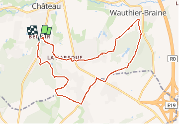
17.1 km | 22 km-effort
4h 56min
![](https://static1.geolcdn.com/siteimages/upload/files/16400158638029165_repeat_loop_refresh_sync_direction_icon.png)
Yes
![Trail Walking Braine-le-Château - RB-Bw-14_Braine-le-Château - Photo](https://media.geolcdn.com/t/375/260/ext.jpg?maxdim=2&url=https%3A%2F%2Fservices.sitytrail.com%2FGeolivesWS%2FDownloadMedia.ashx%3FTrailID%3D179589%26Media%3D13780112-341f-4401-b493-338d7230657e.jpg)
![Walking Walking](https://static1.geolcdn.com/sitytour/trail-icons/101.png)
RB-Bw-14_Braine-le-Château
Walking
Very difficult
(7)
Braine-le-Château,
Wallonia,
Walloon Brabant,
Belgium
![](/images/other/stat-length.png)
23 km | 29 km-effort
6h 30min
![](https://static1.geolcdn.com/siteimages/upload/files/16400158638029165_repeat_loop_refresh_sync_direction_icon.png)
Yes
![Trail Walking Braine-le-Château - RB-Bw-14 - Raccourci 2 - Au nord de Braine-le-Château, à travers de petites réserves naturelles - Photo](https://media.geolcdn.com/t/375/260/ext.jpg?maxdim=2&url=https%3A%2F%2Fstatic1.geolcdn.com%2Fsiteimages%2Fupload%2Ffiles%2F1553511878bg_sport_marche.png)
![Walking Walking](https://static1.geolcdn.com/sitytour/trail-icons/101.png)
RB-Bw-14 - Raccourci 2 - Au nord de Braine-le-Château, à travers de petites r...
Walking
Difficult
(12)
Braine-le-Château,
Wallonia,
Walloon Brabant,
Belgium
![](/images/other/stat-length.png)
11.2 km | 14.9 km-effort
3h 22min
![](https://static1.geolcdn.com/siteimages/upload/files/16400158638029165_repeat_loop_refresh_sync_direction_icon.png)
Yes
![Trail Walking Braine-le-Château - Marche Adeps á Braine-le-Château - Photo](https://media.geolcdn.com/t/375/260/ext.jpg?maxdim=2&url=https%3A%2F%2Fmedia.geolcdn.com%2Ff%2Fdd34770a-5ca3-45b4-9e04-c11066a91570.jpg)
![Walking Walking](https://static1.geolcdn.com/sitytour/trail-icons/101.png)
Marche Adeps á Braine-le-Château
Walking
Very easy
(1)
Braine-le-Château,
Wallonia,
Walloon Brabant,
Belgium
![](/images/other/stat-length.png)
10.5 km | 13.7 km-effort
3h 6min
![](https://static1.geolcdn.com/siteimages/upload/files/16400158638029165_repeat_loop_refresh_sync_direction_icon.png)
Yes
![Trail Walking Braine-le-Château - Balade à Braine-le-Château - Photo](https://media.geolcdn.com/t/375/260/ext.jpg?maxdim=2&url=https%3A%2F%2Fservices.sitytrail.com%2FGeolivesWS%2FDownloadMedia.ashx%3FTrailID%3D566873%26Media%3Da3e1e9d2-1e6f-4d9d-bc93-2d87d42c6412.JPG)
![Walking Walking](https://static1.geolcdn.com/sitytour/trail-icons/101.png)
Balade à Braine-le-Château
Walking
Easy
(2)
Braine-le-Château,
Wallonia,
Walloon Brabant,
Belgium
![](/images/other/stat-length.png)
10.8 km | 13.7 km-effort
3h 0min
![](https://static1.geolcdn.com/siteimages/upload/files/16400158638029165_repeat_loop_refresh_sync_direction_icon.png)
Yes
![Trail Walking Halle - Balade dans le Bois de Halle - Photo](https://media.geolcdn.com/t/375/260/ext.jpg?maxdim=2&url=https%3A%2F%2Fservices.sitytrail.com%2FGeolivesWS%2FDownloadMedia.ashx%3FTrailID%3D411974%26Media%3D4cfcce27-edaf-4211-9dbe-1277fff36f47.JPG)
![Walking Walking](https://static1.geolcdn.com/sitytour/trail-icons/101.png)
Balade dans le Bois de Halle
Walking
Easy
(2)
Halle,
Flanders,
Flemish Brabant,
Belgium
![](/images/other/stat-length.png)
8.6 km | 10.5 km-effort
2h 14min
![](https://static1.geolcdn.com/siteimages/upload/files/16400158638029165_repeat_loop_refresh_sync_direction_icon.png)
Yes
![Trail Walking Ittre - #230717 - Virginal-Samme, Ardennes et Grand Bois, dont 2,5 km du GRP 127 - Photo](https://media.geolcdn.com/t/375/260/ext.jpg?maxdim=2&url=https%3A%2F%2Fmedia.geolcdn.com%2Ff%2Fa1bf3781-faa3-42ce-ad27-95d55194ea2b.JPG)
![Walking Walking](https://static1.geolcdn.com/sitytour/trail-icons/101.png)
#230717 - Virginal-Samme, Ardennes et Grand Bois, dont 2,5 km du GRP 127
Walking
Medium
(1)
Ittre,
Wallonia,
Walloon Brabant,
Belgium
![](/images/other/stat-length.png)
5.1 km | 6.4 km-effort
1h 27min
![](https://static1.geolcdn.com/siteimages/upload/files/16400158638029165_repeat_loop_refresh_sync_direction_icon.png)
Yes
![Trail Walking Ittre - #221031 - Virginal-Samme, Bois des Nonnes, Canal, GRP127 - Photo](https://media.geolcdn.com/t/375/260/ext.jpg?maxdim=2&url=https%3A%2F%2Fmedia.geolcdn.com%2Ff%2F39ed8962-616f-4a1f-b53c-ede91666e492.JPG)
![Walking Walking](https://static1.geolcdn.com/sitytour/trail-icons/101.png)
#221031 - Virginal-Samme, Bois des Nonnes, Canal, GRP127
Walking
Medium
(1)
Ittre,
Wallonia,
Walloon Brabant,
Belgium
![](/images/other/stat-length.png)
8.2 km | 9.9 km-effort
2h 15min
![](https://static1.geolcdn.com/siteimages/upload/files/16400158638029165_repeat_loop_refresh_sync_direction_icon.png)
Yes
![Trail Walking Braine-le-Château - #201214 - Braine-le-Château, Les Monts, Les Fonds et Bruyère Landuyt - Photo](https://media.geolcdn.com/t/375/260/ext.jpg?maxdim=2&url=https%3A%2F%2Fmedia.geolcdn.com%2Ff%2Fe34a4249-4548-4a9c-8500-1f18c72ef5fa.JPG)
![Walking Walking](https://static1.geolcdn.com/sitytour/trail-icons/101.png)
#201214 - Braine-le-Château, Les Monts, Les Fonds et Bruyère Landuyt
Walking
Medium
(1)
Braine-le-Château,
Wallonia,
Walloon Brabant,
Belgium
![](/images/other/stat-length.png)
7.8 km | 10.2 km-effort
2h 11min
![](https://static1.geolcdn.com/siteimages/upload/files/16400158638029165_repeat_loop_refresh_sync_direction_icon.png)
Yes