![](/images/other/stat-length.png)
![Trail Walking Saint-Vincent - St_Vincent_Puy_Lavelle_JG_02 - Photo](https://media.geolcdn.com/t/1900/400/a3fc96ef-efb3-4784-a23c-0f44c0b5ca63.jpg&format=pjpeg&maxdim=2)
St_Vincent_Puy_Lavelle_JG_02
jagarnier
User GUIDE
![Length](/images/other/stat-length.png)
Length
10.1 km
![Max alt](https://static1.geolcdn.com/siteimages/upload/files/1508320355ic_sort_altitude_max_24dp.png)
Max alt
771 m
![Uphill gradient](https://static1.geolcdn.com/siteimages/upload/files/1508320355ic_sort_den_pos_24dp.png)
Uphill gradient
365 m
![Km-Effort](/images/other/stat-length.png)
Km-Effort
14.9 km
![Min alt](https://static1.geolcdn.com/siteimages/upload/files/1508320355ic_sort_altitude_min_24dp.png)
Min alt
463 m
![Downhill gradient](https://static1.geolcdn.com/siteimages/upload/files/1508320355ic_sort_den_neg_24dp.png)
Downhill gradient
364 m
![Boucle](https://static1.geolcdn.com/siteimages/upload/files/16400158638029165_repeat_loop_refresh_sync_direction_icon.png)
Boucle
Yes
Creation date :
2018-05-29 05:58:25.102
Updated on :
2022-01-06 07:11:26.342
![Walking](https://static1.geolcdn.com/sitytour/trail-icons/101.png)
3h00
Difficulty : Medium
![Scan this QR Code to open this trail in the SityTrail application](https://capi.geolives.com/qq0zvz2zws4bq2lad0pu/sitytour/trails/2002037/qr.png?size=200)
FREE GPS app for hiking
About
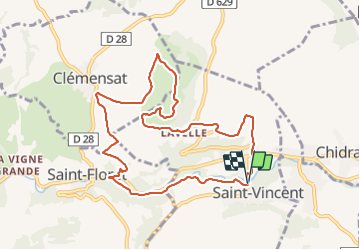
Trail Walking of 10.1 km to be discovered at Auvergne-Rhône-Alpes, Puy-de-Dôme, Saint-Vincent. This trail is proposed by jagarnier.
Description
Depuis Saint-Vincent vous traverserez des coteaux assez arides caractéristiques du sud du Puy-de-Dôme. Tout autours du puy de Lavelle vous aurez une belle vue sur Issoire, le Lembron et le massif du Sancy.
Positioning
Country:
France
Region :
Auvergne-Rhône-Alpes
Department/Province :
Puy-de-Dôme
Municipality :
Saint-Vincent
Location:
Unknown
Start:(Dec)
Start:(UTM)
510352 ; 5044115 (31T) N.
Comments
Trails nearby
![Trail Walking Champeix - Champeix_St_Julien - Photo](https://media.geolcdn.com/t/375/260/42c319f4-7a47-48dd-bf0b-2587fad533a9.jpg&format=jpg&maxdim=2)
![Walking Walking](https://static1.geolcdn.com/sitytour/trail-icons/101.png)
Champeix_St_Julien
Walking
Easy
(1)
Champeix,
Auvergne-Rhône-Alpes,
Puy-de-Dôme,
France
![](/images/other/stat-length.png)
9.1 km | 12.3 km-effort
2h 45min
![](https://static1.geolcdn.com/siteimages/upload/files/16400158638029165_repeat_loop_refresh_sync_direction_icon.png)
Yes
![Trail Walking Montaigut-le-Blanc - Le ravin de Quinsat - Montaigut le Blanc - Photo](https://media.geolcdn.com/t/375/260/ext.jpg?maxdim=2&url=https%3A%2F%2Fservices.sitytrail.com%2FGeolivesWS%2FDownloadMedia.ashx%3FTrailID%3D104453%26Media%3D7707_2.jpg)
![Walking Walking](https://static1.geolcdn.com/sitytour/trail-icons/101.png)
Le ravin de Quinsat - Montaigut le Blanc
Walking
Medium
(1)
Montaigut-le-Blanc,
Auvergne-Rhône-Alpes,
Puy-de-Dôme,
France
![](/images/other/stat-length.png)
7.7 km | 11.6 km-effort
2h 0min
![](https://static1.geolcdn.com/siteimages/upload/files/16400158638029165_repeat_loop_refresh_sync_direction_icon.png)
Yes
![Trail On foot Montaigut-le-Blanc - Les caves de Saint-Julien - Photo](https://media.geolcdn.com/t/375/260/cfc5ce46-7f0d-433e-93c8-aa40e374d5a2.jpeg&format=jpg&maxdim=2)
![On foot On foot](https://static1.geolcdn.com/sitytour/trail-icons/100.png)
Les caves de Saint-Julien
On foot
Easy
Montaigut-le-Blanc,
Auvergne-Rhône-Alpes,
Puy-de-Dôme,
France
![](/images/other/stat-length.png)
7.7 km | 10.7 km-effort
2h 26min
![](https://static1.geolcdn.com/siteimages/upload/files/16400158638029165_repeat_loop_refresh_sync_direction_icon.png)
No
![Trail On foot Champeix - La Pierre-Fichade - Photo](https://media.geolcdn.com/t/375/260/d1a5f8f1-78ee-45c6-ac5d-3641d548b5c5.jpeg&format=jpg&maxdim=2)
![On foot On foot](https://static1.geolcdn.com/sitytour/trail-icons/100.png)
La Pierre-Fichade
On foot
Easy
Champeix,
Auvergne-Rhône-Alpes,
Puy-de-Dôme,
France
![](/images/other/stat-length.png)
6.3 km | 8.8 km-effort
1h 59min
![](https://static1.geolcdn.com/siteimages/upload/files/16400158638029165_repeat_loop_refresh_sync_direction_icon.png)
Yes
![Trail On foot Montaigut-le-Blanc - Le Tour de la Piniere - Photo](https://media.geolcdn.com/t/375/260/4a1014d7-c9fa-4749-bab6-e03a04c0bb47.jpeg&format=jpg&maxdim=2)
![On foot On foot](https://static1.geolcdn.com/sitytour/trail-icons/100.png)
Le Tour de la Piniere
On foot
Easy
Montaigut-le-Blanc,
Auvergne-Rhône-Alpes,
Puy-de-Dôme,
France
![](/images/other/stat-length.png)
8.9 km | 12.9 km-effort
2h 55min
![](https://static1.geolcdn.com/siteimages/upload/files/16400158638029165_repeat_loop_refresh_sync_direction_icon.png)
Yes
![Trail On foot Saint-Floret - La Chaubasse - Photo](https://media.geolcdn.com/t/375/260/768fec42-41d9-4005-9393-314a0342ff62.jpeg&format=jpg&maxdim=2)
![On foot On foot](https://static1.geolcdn.com/sitytour/trail-icons/100.png)
La Chaubasse
On foot
Easy
Saint-Floret,
Auvergne-Rhône-Alpes,
Puy-de-Dôme,
France
![](/images/other/stat-length.png)
9.4 km | 14.2 km-effort
3h 13min
![](https://static1.geolcdn.com/siteimages/upload/files/16400158638029165_repeat_loop_refresh_sync_direction_icon.png)
Yes
![Trail On foot Saint-Floret - Clemensat - Photo](https://media.geolcdn.com/t/375/260/768fec42-41d9-4005-9393-314a0342ff62.jpeg&format=jpg&maxdim=2)
![On foot On foot](https://static1.geolcdn.com/sitytour/trail-icons/100.png)
Clemensat
On foot
Easy
Saint-Floret,
Auvergne-Rhône-Alpes,
Puy-de-Dôme,
France
![](/images/other/stat-length.png)
5.8 km | 8.1 km-effort
1h 50min
![](https://static1.geolcdn.com/siteimages/upload/files/16400158638029165_repeat_loop_refresh_sync_direction_icon.png)
Yes
![Trail On foot Saint-Vincent - Lavelle - Photo](https://media.geolcdn.com/t/375/260/297b1057-563f-4657-92b7-0e66d7544f1c.jpeg&format=jpg&maxdim=2)
![On foot On foot](https://static1.geolcdn.com/sitytour/trail-icons/100.png)
Lavelle
On foot
Easy
Saint-Vincent,
Auvergne-Rhône-Alpes,
Puy-de-Dôme,
France
![](/images/other/stat-length.png)
10 km | 14.7 km-effort
3h 21min
![](https://static1.geolcdn.com/siteimages/upload/files/16400158638029165_repeat_loop_refresh_sync_direction_icon.png)
Yes
![Trail On foot Montaigut-le-Blanc - Le Puy de la Rodde - Photo](https://media.geolcdn.com/t/375/260/4a1014d7-c9fa-4749-bab6-e03a04c0bb47.jpeg&format=jpg&maxdim=2)
![On foot On foot](https://static1.geolcdn.com/sitytour/trail-icons/100.png)
Le Puy de la Rodde
On foot
Easy
Montaigut-le-Blanc,
Auvergne-Rhône-Alpes,
Puy-de-Dôme,
France
![](/images/other/stat-length.png)
6.9 km | 10.7 km-effort
2h 25min
![](https://static1.geolcdn.com/siteimages/upload/files/16400158638029165_repeat_loop_refresh_sync_direction_icon.png)
No