6.5 km | 7.5 km-effort
Gouvix
Jeff_314
User
Length
5.7 km
Max alt
118 m
Uphill gradient
47 m
Km-Effort
6.3 km
Min alt
89 m
Downhill gradient
47 m
Boucle
Yes
Creation date :
2014-12-10 00:00:00.0
Updated on :
2014-12-10 00:00:00.0
1h50
Difficulty : Easy
FREE GPS app for hiking
About
Trail Walking of 5.7 km to be discovered at Normandy, Calvados, Gouvix. This trail is proposed by Jeff_314.
Description
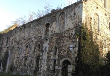
les fours, l'ancienne ligne de chemin de fer
Positioning
Country:
France
Region :
Normandy
Department/Province :
Calvados
Municipality :
Gouvix
Location:
Unknown
Start:(Dec)
Start:(UTM)
697229 ; 5435223 (30U) N.
Comments
Trails nearby
GC745R5 = https://coord.info/GC745R5
Geocaching
Easy
Barbery,
Normandy,
Calvados,
France
2h 40min
Yes
Autour de Poussy-la-Campagne
On foot
Easy
Valambray,
Normandy,
Calvados,
France
5 km | 5.3 km-effort
1h 12min
Yes
VTT autour de Barbery
Mountain bike
Medium
Barbery,
Normandy,
Calvados,
France
40 km | 47 km-effort
2h 30min
Yes
Bretteville sur Laize / Urville
On foot
Easy
(1)
Bretteville-sur-Laize,
Normandy,
Calvados,
France
15.3 km | 18 km-effort
4h 5min
Yes
Urville et La Laize
Walking
Medium
Urville,
Normandy,
Calvados,
France
5.1 km | 6.2 km-effort
1h 43min
Yes
Pays du Cinglais
Mountain bike
Medium
Cintheaux,
Normandy,
Calvados,
France
38 km | 43 km-effort
2h 15min
Yes
A faire avec Simon
sport
Very easy
Le Castelet,
Normandy,
Calvados,
France
24 km | 26 km-effort
Unknown
Yes
14/04/2024: balade dominicale
sport
Very easy
Le Castelet,
Normandy,
Calvados,
France
23 km | 25 km-effort
Unknown
Yes