![](/images/other/stat-length.png)
![Trail Bicycle tourism Mirande - Mirande - Les 3 soeurs de l'Astarac - Photo](https://media.geolcdn.com/t/1900/400/ext.pjpeg?maxdim=2&url=https%3A%2F%2Fstatic1.geolcdn.com%2Fsiteimages%2Fupload%2Ffiles%2F1524743154velo.jpg)
Mirande - Les 3 soeurs de l'Astarac
potofe
User
![Length](/images/other/stat-length.png)
![Max alt](https://static1.geolcdn.com/siteimages/upload/files/1508320355ic_sort_altitude_max_24dp.png)
![Uphill gradient](https://static1.geolcdn.com/siteimages/upload/files/1508320355ic_sort_den_pos_24dp.png)
![Km-Effort](/images/other/stat-length.png)
![Min alt](https://static1.geolcdn.com/siteimages/upload/files/1508320355ic_sort_altitude_min_24dp.png)
![Downhill gradient](https://static1.geolcdn.com/siteimages/upload/files/1508320355ic_sort_den_neg_24dp.png)
![Boucle](https://static1.geolcdn.com/siteimages/upload/files/16400158638029165_repeat_loop_refresh_sync_direction_icon.png)
![Bicycle tourism](https://static1.geolcdn.com/sitytour/trail-icons/204.png)
--
Difficulty : Very easy
![Scan this QR Code to open this trail in the SityTrail application](https://capi.geolives.com/qq0zvz2zws4bq2lad0pu/sitytour/trails/198580/qr.png?size=200)
FREE GPS app for hiking
About
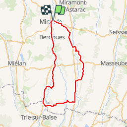
Trail Bicycle tourism of 56 km to be discovered at Occitania, Gers, Mirande. This trail is proposed by potofe.
Description
Ce circuit nous fait franchir trois des rivières gersoises : les ''Baïse''. Comme la rivière Gers qui a donné son nom à notre département, elles prennent leur source au pied des Pyrénées sur le plateau de Lannemezan et forment l''éventail hydraulique gascon.
En partant de Mirande, remontons le cours de la première des soeurs qui tiennent leur nom de l''éthymologie celte : rivière au cours paisible. C''est la Grande Baïse qui va nous mener aux confins du Gers avec comme décor les Pyrénées.
Duffort et ses coteaux nous dirigent vers l''autre soeur : la Baïsole (petite Baïse en occitan). Elle rejoint sa grande soeur à Saint-Michel.
Saint-Ost nous fait découvrir la troisième, la petite Baïse ou du devant (est). Le long de ces trois vallées vous pourrez observer leur dissymétrie : rive droite abrupte (La Serre) et rive gauche étalée (La Boubée). Ce phénomène est unique et typique aux rivières gersoises.
Les deux Baïse n''en font qu''une à l''Isle-de-Noé, qui rejoint la Garonne à Aiguillon (Lot-et-Garonne).
On pourra observer chemin faisant les corps de ferme en équerre et d''anciens points de défense. Ce sont les mottes castrales les mieux conservées et les plus impressionnantes de cette partie du Gers : l''Astarac (en celte : le pays de pierre).
Positioning
Comments
Trails nearby
![Trail On foot Saint-Martin - SAINT-MARTIN G4 le sentier des clouques - Photo](https://media.geolcdn.com/t/375/260/1f87faa3-90d7-4ec2-b240-bb7d1d763751.jpg&format=jpg&maxdim=2)
![On foot On foot](https://static1.geolcdn.com/sitytour/trail-icons/100.png)
On foot
![](/images/other/stat-length.png)
![](https://static1.geolcdn.com/siteimages/upload/files/16400158638029165_repeat_loop_refresh_sync_direction_icon.png)
![Trail Walking Saint-Martin - SAINT-MARTIN Mirande le sentier des clouques reco G4 3005118 - Photo](https://media.geolcdn.com/t/375/260/7cfdf899-d281-4093-b5ae-71af87319722.jpg&format=jpg&maxdim=2)
![Walking Walking](https://static1.geolcdn.com/sitytour/trail-icons/101.png)
Walking
![](/images/other/stat-length.png)
![](https://static1.geolcdn.com/siteimages/upload/files/16400158638029165_repeat_loop_refresh_sync_direction_icon.png)
![Trail Walking Saint-Martin - sentier des Cloques Saint Martin - Photo](https://media.geolcdn.com/t/375/260/ext.jpg?maxdim=2&url=https%3A%2F%2Fstatic1.geolcdn.com%2Fsiteimages%2Fupload%2Ffiles%2F1553511878bg_sport_marche.png)
![Walking Walking](https://static1.geolcdn.com/sitytour/trail-icons/101.png)
Walking
![](/images/other/stat-length.png)
![](https://static1.geolcdn.com/siteimages/upload/files/16400158638029165_repeat_loop_refresh_sync_direction_icon.png)
![Trail Walking Berdoues - Rando Véro départ Berdoues - Photo](https://media.geolcdn.com/t/375/260/ext.jpg?maxdim=2&url=https%3A%2F%2Fstatic1.geolcdn.com%2Fsiteimages%2Fupload%2Ffiles%2F1553511878bg_sport_marche.png)
![Walking Walking](https://static1.geolcdn.com/sitytour/trail-icons/101.png)
Walking
![](/images/other/stat-length.png)
![](https://static1.geolcdn.com/siteimages/upload/files/16400158638029165_repeat_loop_refresh_sync_direction_icon.png)
![Trail Walking Estipouy - autour d'entarrieux - Photo](https://media.geolcdn.com/t/375/260/ext.jpg?maxdim=2&url=https%3A%2F%2Fstatic1.geolcdn.com%2Fsiteimages%2Fupload%2Ffiles%2F1553511878bg_sport_marche.png)
![Walking Walking](https://static1.geolcdn.com/sitytour/trail-icons/101.png)
Walking
![](/images/other/stat-length.png)
![](https://static1.geolcdn.com/siteimages/upload/files/16400158638029165_repeat_loop_refresh_sync_direction_icon.png)
![Trail Cycle Estipouy - grande boucle de barran - Photo](https://media.geolcdn.com/t/375/260/ext.jpg?maxdim=2&url=https%3A%2F%2Fstatic1.geolcdn.com%2Fsiteimages%2Fupload%2Ffiles%2F1524743154velo.jpg)
![Cycle Cycle](https://static1.geolcdn.com/sitytour/trail-icons/200.png)
Cycle
![](/images/other/stat-length.png)
![](https://static1.geolcdn.com/siteimages/upload/files/16400158638029165_repeat_loop_refresh_sync_direction_icon.png)
![Trail Mountain bike Miramont-d'Astarac - seissan - Photo](https://media.geolcdn.com/t/375/260/ext.jpg?maxdim=2&url=https%3A%2F%2Fstatic1.geolcdn.com%2Fsiteimages%2Fupload%2Ffiles%2F1524743154velo.jpg)
![Mountain bike Mountain bike](https://static1.geolcdn.com/sitytour/trail-icons/202.png)
Mountain bike
![](/images/other/stat-length.png)
![](https://static1.geolcdn.com/siteimages/upload/files/16400158638029165_repeat_loop_refresh_sync_direction_icon.png)
![Trail Mountain bike Estipouy - petit velo - Photo](https://media.geolcdn.com/t/375/260/ext.jpg?maxdim=2&url=https%3A%2F%2Fstatic1.geolcdn.com%2Fsiteimages%2Fupload%2Ffiles%2F1524743154velo.jpg)
![Mountain bike Mountain bike](https://static1.geolcdn.com/sitytour/trail-icons/202.png)
![Trail Mountain bike Estipouy - entre 2 lacs - Photo](https://media.geolcdn.com/t/375/260/ext.jpg?maxdim=2&url=https%3A%2F%2Fstatic1.geolcdn.com%2Fsiteimages%2Fupload%2Ffiles%2F1524743154velo.jpg)
![Mountain bike Mountain bike](https://static1.geolcdn.com/sitytour/trail-icons/202.png)
Mountain bike
![](/images/other/stat-length.png)
![](https://static1.geolcdn.com/siteimages/upload/files/16400158638029165_repeat_loop_refresh_sync_direction_icon.png)