Trail Walking Lédenon - MJW 9-01 - Photo
 hubbi
hubbi

User

© OpenStreetMap contributors
Length
Length
18.3 km
Max alt
Max alt
207 m
Uphill gradient
Uphill gradient
357 m
Km-Effort
Km-Effort  
23 km
Min alt
Min alt
72 m
Downhill gradient
Downhill gradient
403 m
Boucle
Boucle
No
Creation date :
2014-12-10 00:00:00.0
Updated on :
2014-12-10 00:00:00.0

(0 Reviews)

Walking
Walking
4h56
Difficulty : Easy

Scan this QR Code to open this trail in the SityTrail application

FREE GPS app for hiking

Logo SityTrail SityTrail

IGN / Geographical institutes

Download SityTrail from the App Store Download SityTrail from Google Play

Logo SityTrail SityTrail World

The world is yours!

Download SityTrail from the App Store Download SityTrail from Google Play Download SityTrail on Huawei AppGallery

About

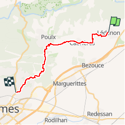
Trail Walking of 18.3 km to be discovered at Occitania, Gard, Lédenon. This trail is proposed by hubbi.

Description

Von Lédenon nach Nîmes-la Gazelle

Elevation profile

Positioning

Country:
France
Region :
Occitania
Department/Province :
Gard
Municipality :
Lédenon
Location:
Unknown
Start:(UTM)
621167 ; 4863519 (31T) N.

Trails nearby

Trail Walking Vers-Pont-du-Gard - Rando pont du Gard - Photo
Walking
SabetMick

Walking

Easy
(1)
Vers-Pont-du-Gard, Occitania, Gard, France
6.8 km | 8.6 km-effort
2h 49min
No
Trail Walking Saint-Bonnet-du-Gard - Le Pont du Gard - Photo
Walking
VacheKiri67

Walking

Difficult
(2)
Saint-Bonnet-du-Gard, Occitania, Gard, France
18.6 km | 24 km-effort
5h 30min
Yes
Trail Walking Collias - La Baume par Collias - Photo
Walking
tracegps

Walking

Medium
(3)
Collias, Occitania, Gard, France
13.3 km | 18.1 km-effort
4h 0min
Yes
Trail Walking Collias - PF-Collias - Les Gorges du Gardon - Photo
Walking
MicDul

Walking

Easy
(1)
Collias, Occitania, Gard, France
12.9 km | 16.4 km-effort
3h 39min
Yes
Trail Road bike Cabrières - 30 pont du Gard colias velo - Photo
Road bike
GUIDE
randodyssée

Road bike

Medium
Cabrières, Occitania, Gard, France
36 km | 41 km-effort
3h 5min
Yes
Trail Walking Saint-Bonnet-du-Gard - Chemins oubliés de l'Aqueduc  - Photo
Walking
GUIDE
nadinebondoux

Walking

Medium
Saint-Bonnet-du-Gard, Occitania, Gard, France
12.7 km | 16.5 km-effort
3h 39min
Yes
Trail On foot Collias - L'Ermitage de Collias - Photo
On foot
GUIDE+

On foot

Easy
Collias, Occitania, Gard, France
5.3 km | 7 km-effort
1h 35min
No
Trail Walking Cabrières - 30 gardon bois des coufines - Photo
Walking
GUIDE
randodyssée

Walking

Easy
Cabrières, Occitania, Gard, France
11.4 km | 15.6 km-effort
4h 30min
No
Trail Walking Lédenon - Sernhac / Saint Bonnet /Pont du Gard/ Ledenon - Photo
Walking
GUIDE
nadinebondoux

Walking

Medium
Lédenon, Occitania, Gard, France
18.7 km | 25 km-effort
5h 23min
Yes


Close
My subscriptions