Trail Other activity Eriswil - Eriswil - Ahorn zum Napf - Photo
© OpenStreetMap contributors
Length
Length
15.8 km
Max alt
Max alt
1398 m
Uphill gradient
Uphill gradient
1000 m
Km-Effort
Km-Effort  
27 km
Min alt
Min alt
740 m
Downhill gradient
Downhill gradient
353 m
Boucle
Boucle
No
Creation date :
2014-12-11 00:00:00.0
Updated on :
2014-12-11 00:00:00.0

(0 Reviews)

Other activity
Other activity
--
Difficulty : Unknown

Scan this QR Code to open this trail in the SityTrail application

FREE GPS app for hiking

Logo SityTrail SityTrail

IGN / Geographical institutes

Download SityTrail from the App Store Download SityTrail from Google Play

Logo SityTrail SityTrail World

The world is yours!

Download SityTrail from the App Store Download SityTrail from Google Play Download SityTrail on Huawei AppGallery

About

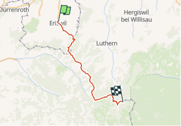
Trail Other activity of 15.8 km to be discovered at Bern, Oberaargau administrative district, Eriswil. This trail is proposed by bayardpaul.

Description

Leubin-Huber Hansrudolf
Bahnhofstrasse 51
4132 Muttenz
061 461 43 28

Elevation profile

Positioning

Country:
Switzerland
Region :
Bern
Department/Province :
Oberaargau administrative district
Municipality :
Eriswil
Location:
Unknown
Start:(UTM)
412792 ; 5214632 (32T) N.

Trails nearby

Trail On foot Eriswil - Eriswil - Wyssachen - Photo
On foot
PRO

On foot

Easy
Eriswil, Bern, Oberaargau administrative district, Switzerland
3 km | 4.9 km-effort
1h 6min
No
Trail On foot Sumiswald - Wasen i. E. - Vorderarni - Photo
On foot
PRO

On foot

Easy
Sumiswald, Bern, Emmental administrative district, Switzerland
3.5 km | 6.8 km-effort
1h 33min
No
Trail On foot Dürrenroth - Affoltern Weier - Oberwald Schaber - Photo
On foot
PRO

On foot

Easy
Dürrenroth, Bern, Emmental administrative district, Switzerland
4.3 km | 5.6 km-effort
1h 16min
No
Trail On foot Wyssachen - Wyssachen - Dürrenroth - Photo
On foot
PRO

On foot

Easy
Wyssachen, Bern, Oberaargau administrative district, Switzerland
3.5 km | 5 km-effort
1h 8min
No
Trail On foot Dürrenroth - Dürrenroth - Guggli - Photo
On foot
PRO

On foot

Easy
Dürrenroth, Bern, Emmental administrative district, Switzerland
3.7 km | 6.4 km-effort
1h 27min
No
Trail On foot Dürrenroth - Dürrenroth - Oberwald - Photo
On foot
PRO

On foot

Easy
Dürrenroth, Bern, Emmental administrative district, Switzerland
5.2 km | 7.9 km-effort
1h 47min
No
Trail On foot Ufhusen - Ob. Hilferdingen - Älbachegg - Photo
On foot
PRO

On foot

Easy
Ufhusen, Luzern, Unknown, Switzerland
3.1 km | 4.9 km-effort
1h 7min
No
Trail On foot Eriswil - Hegen - Ob. Hiferdingen - Photo
On foot
PRO

On foot

Easy
Eriswil, Bern, Oberaargau administrative district, Switzerland
3.4 km | 4.1 km-effort
55min
No
Trail On foot Huttwil - Huttwilerberg - Hohwacht - Photo
On foot
PRO

On foot

Easy
Huttwil, Bern, Oberaargau administrative district, Switzerland
5.4 km | 7.2 km-effort
1h 37min
No


Close
My subscriptions