![](/images/other/stat-length.png)
![Trail Other activity Sempach - Anfahrt ab Autobahnausfahrt Sempach - Photo](https://media.geolcdn.com/t/1900/400/ext.pjpeg?maxdim=2&url=https%3A%2F%2Fstatic1.geolcdn.com%2Fsiteimages%2Fupload%2Ffiles%2F1545311037marcheuse_200dpi.jpg)
Anfahrt ab Autobahnausfahrt Sempach
fritz
User
![Length](/images/other/stat-length.png)
![Max alt](https://static1.geolcdn.com/siteimages/upload/files/1508320355ic_sort_altitude_max_24dp.png)
![Uphill gradient](https://static1.geolcdn.com/siteimages/upload/files/1508320355ic_sort_den_pos_24dp.png)
![Km-Effort](/images/other/stat-length.png)
![Min alt](https://static1.geolcdn.com/siteimages/upload/files/1508320355ic_sort_altitude_min_24dp.png)
![Downhill gradient](https://static1.geolcdn.com/siteimages/upload/files/1508320355ic_sort_den_neg_24dp.png)
![Boucle](https://static1.geolcdn.com/siteimages/upload/files/16400158638029165_repeat_loop_refresh_sync_direction_icon.png)
![Other activity](https://static1.geolcdn.com/sitytour/trail-icons/900.png)
--
Difficulty : Unknown
![Scan this QR Code to open this trail in the SityTrail application](https://capi.geolives.com/qq0zvz2zws4bq2lad0pu/sitytour/trails/19710/qr.png?size=200)
FREE GPS app for hiking
About
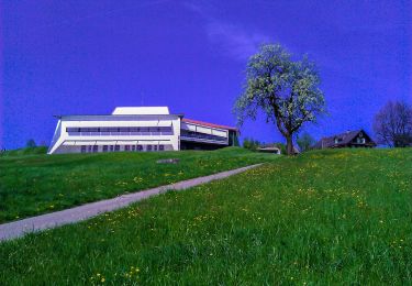
Trail Other activity of 9.4 km to be discovered at Luzern, Unknown, Sempach. This trail is proposed by fritz.
Description
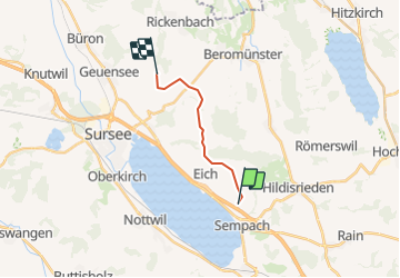
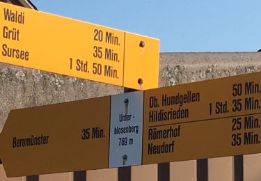
Die Anfahrt ist ab Sempach mit der rot gestrichelten Linie markiert. Sie fahren Richtung Vogelsang-Waldi-Rickenbach. ca. 1 km nach Waldi sehen Sie links die ehemaligen Käserei Holdern. Dort biegen Sie links ab und folgen den Holzwegweisern Richtung Diegenstal oder den kleinen Wegweisern "Bauer Fritz". Sie können auf Wunsch die Karte auch näher zoomen.
Positioning
Comments
Trails nearby
![Trail On foot Beromünster - Neudorf - Unter Blosenberg - Photo](https://media.geolcdn.com/t/375/260/a9e8306d-f111-4dfc-9c67-cc4e4df5163f.jpeg&format=jpg&maxdim=2)
![On foot On foot](https://static1.geolcdn.com/sitytour/trail-icons/100.png)
On foot
![](/images/other/stat-length.png)
![](https://static1.geolcdn.com/siteimages/upload/files/16400158638029165_repeat_loop_refresh_sync_direction_icon.png)
![Trail On foot Nottwil - Sempachersee-Moosweg - Photo](https://media.geolcdn.com/t/375/260/5b43a39d-2789-497e-af40-998ef39b5ba7.jpeg&format=jpg&maxdim=2)
![On foot On foot](https://static1.geolcdn.com/sitytour/trail-icons/100.png)
On foot
![](/images/other/stat-length.png)
![](https://static1.geolcdn.com/siteimages/upload/files/16400158638029165_repeat_loop_refresh_sync_direction_icon.png)
![Trail On foot Römerswil - Hildisrieden - Römerswil - Photo](https://media.geolcdn.com/t/375/260/0a4147b2-cbff-44df-a56a-c1941275f40c.jpeg&format=jpg&maxdim=2)
![On foot On foot](https://static1.geolcdn.com/sitytour/trail-icons/100.png)
On foot
![](/images/other/stat-length.png)
![](https://static1.geolcdn.com/siteimages/upload/files/16400158638029165_repeat_loop_refresh_sync_direction_icon.png)
![Trail On foot Beromünster - Morentaler Wald - Blosenberg - Photo](https://media.geolcdn.com/t/375/260/a9e8306d-f111-4dfc-9c67-cc4e4df5163f.jpeg&format=jpg&maxdim=2)
![On foot On foot](https://static1.geolcdn.com/sitytour/trail-icons/100.png)
On foot
![](/images/other/stat-length.png)
![](https://static1.geolcdn.com/siteimages/upload/files/16400158638029165_repeat_loop_refresh_sync_direction_icon.png)
![Trail On foot Beromünster - Waldhaus - Älmeringen -Gormund - Photo](https://media.geolcdn.com/t/375/260/c9cebd51-7d26-4f59-8a42-112d0a21e44a.jpeg&format=jpg&maxdim=2)
![On foot On foot](https://static1.geolcdn.com/sitytour/trail-icons/100.png)
On foot
![](/images/other/stat-length.png)
![](https://static1.geolcdn.com/siteimages/upload/files/16400158638029165_repeat_loop_refresh_sync_direction_icon.png)
![Trail On foot Neuenkirch - Adelwil - Bärtiswil - Photo](https://media.geolcdn.com/t/375/260/d286582e-e630-4410-99ae-955497ecf71b.jpeg&format=jpg&maxdim=2)
![On foot On foot](https://static1.geolcdn.com/sitytour/trail-icons/100.png)
On foot
![](/images/other/stat-length.png)
![](https://static1.geolcdn.com/siteimages/upload/files/16400158638029165_repeat_loop_refresh_sync_direction_icon.png)
![Trail On foot Nottwil - Nottwil - Sempach (Vogelwarte) - Photo](https://media.geolcdn.com/t/375/260/06c2aee0-d9ed-4bae-a21f-a68a34b0e075.jpeg&format=jpg&maxdim=2)
![On foot On foot](https://static1.geolcdn.com/sitytour/trail-icons/100.png)
On foot
![](/images/other/stat-length.png)
![](https://static1.geolcdn.com/siteimages/upload/files/16400158638029165_repeat_loop_refresh_sync_direction_icon.png)
![Trail On foot Schenkon - Schenkon - Eich - Photo](https://media.geolcdn.com/t/375/260/274c9e7b-5c2d-4d8b-8988-66feb5aa3fce.jpeg&format=jpg&maxdim=2)
![On foot On foot](https://static1.geolcdn.com/sitytour/trail-icons/100.png)
![Trail On foot Neuenkirch - Niklaus Wolf Weg - Photo](https://media.geolcdn.com/t/375/260/566428a6-7061-4778-a877-ae993341de8d.jpeg&format=jpg&maxdim=2)
![On foot On foot](https://static1.geolcdn.com/sitytour/trail-icons/100.png)
On foot
![](/images/other/stat-length.png)
![](https://static1.geolcdn.com/siteimages/upload/files/16400158638029165_repeat_loop_refresh_sync_direction_icon.png)