![](/images/other/stat-length.png)
![Trail Walking Olmi-Cappella - Col de Tartagine - Photo](https://media.geolcdn.com/t/1900/400/ext.pjpeg?maxdim=2&url=https%3A%2F%2Fstatic1.geolcdn.com%2Fsiteimages%2Fupload%2Ffiles%2F1553511878bg_sport_marche.png)
Col de Tartagine
jmheydorff
User
![Length](/images/other/stat-length.png)
![Max alt](https://static1.geolcdn.com/siteimages/upload/files/1508320355ic_sort_altitude_max_24dp.png)
![Uphill gradient](https://static1.geolcdn.com/siteimages/upload/files/1508320355ic_sort_den_pos_24dp.png)
![Km-Effort](/images/other/stat-length.png)
![Min alt](https://static1.geolcdn.com/siteimages/upload/files/1508320355ic_sort_altitude_min_24dp.png)
![Downhill gradient](https://static1.geolcdn.com/siteimages/upload/files/1508320355ic_sort_den_neg_24dp.png)
![Boucle](https://static1.geolcdn.com/siteimages/upload/files/16400158638029165_repeat_loop_refresh_sync_direction_icon.png)
![Walking](https://static1.geolcdn.com/sitytour/trail-icons/101.png)
2h44
Difficulty : Medium
![Scan this QR Code to open this trail in the SityTrail application](https://capi.geolives.com/qq0zvz2zws4bq2lad0pu/sitytour/trails/196014/qr.png?size=200)
FREE GPS app for hiking
About
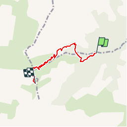
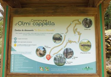
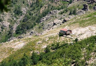
Trail Walking of 4 km to be discovered at Corsica, Haute-Corse, Olmi-Cappella. This trail is proposed by jmheydorff.
Description
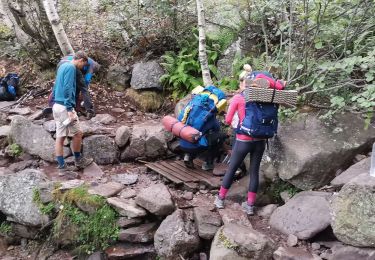
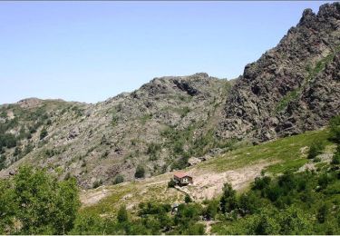
départ Olmi-Cappella , pui D963 (en voiture); au gîte d''étape de Tartagine -Melaja; continuer (en voiture) sur la piste qui suit la Rivière de Tartagine; traverser un premier ruisseau (cote 1173m), d''où l''on peut partir à pied, ou continuer jusqu''au 2° ruisseau (cote 1205m).
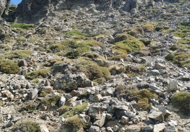
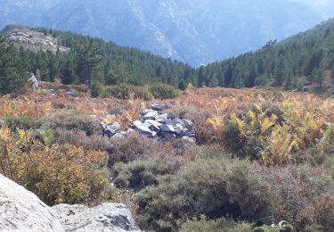
remonter le cours du ruisseau, et monter fortement vers le Col de Tartagine (1852m).
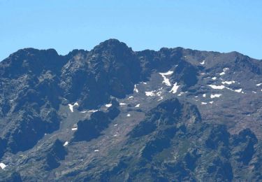
Puis, soit continuer Sud jusqu''au Monte Corona (2144 m), soit redescendre de suite.
Longueur AR 8 kms durée AR 4h30
Positioning
Comments
Trails nearby
![Trail Walking Olmi-Cappella - Monte Corona - Photo](https://media.geolcdn.com/t/375/260/ext.jpg?maxdim=2&url=https%3A%2F%2Fservices.sitytrail.com%2FGeolivesWS%2FDownloadMedia.ashx%3FTrailID%3D101511%26Media%3D1616_2.jpg)
![Walking Walking](https://static1.geolcdn.com/sitytour/trail-icons/101.png)
Walking
![](/images/other/stat-length.png)
![](https://static1.geolcdn.com/siteimages/upload/files/16400158638029165_repeat_loop_refresh_sync_direction_icon.png)
![Trail Walking Calenzana - Gr20 Caruzzo Ascorbique - Photo](https://media.geolcdn.com/t/375/260/283be13d-2a81-40ab-b602-c3c97bf8108c.jpg&format=jpg&maxdim=2)
![Walking Walking](https://static1.geolcdn.com/sitytour/trail-icons/101.png)
Walking
![](/images/other/stat-length.png)
![](https://static1.geolcdn.com/siteimages/upload/files/16400158638029165_repeat_loop_refresh_sync_direction_icon.png)
![Trail Walking Calenzana - Ortu di u piobbu. Carozzu - Photo](https://media.geolcdn.com/t/375/260/89350b82-74c0-4665-8cba-390c49fa51b8.jpg&format=jpg&maxdim=2)
![Walking Walking](https://static1.geolcdn.com/sitytour/trail-icons/101.png)
Walking
![](/images/other/stat-length.png)
![](https://static1.geolcdn.com/siteimages/upload/files/16400158638029165_repeat_loop_refresh_sync_direction_icon.png)
![Walking Walking](https://static1.geolcdn.com/sitytour/trail-icons/101.png)
Walking
![](/images/other/stat-length.png)
![](https://static1.geolcdn.com/siteimages/upload/files/16400158638029165_repeat_loop_refresh_sync_direction_icon.png)
![Trail Walking Calenzana - monte grosso, au départ de la Flatta - Photo](https://media.geolcdn.com/t/375/260/daa4ae87-88e6-472b-ab61-ca61cbaf1ac9.jpg&format=jpg&maxdim=2)
![Walking Walking](https://static1.geolcdn.com/sitytour/trail-icons/101.png)
Walking
![](/images/other/stat-length.png)
![](https://static1.geolcdn.com/siteimages/upload/files/16400158638029165_repeat_loop_refresh_sync_direction_icon.png)
![Trail Walking Calenzana - RG20 Corse étape 2 - Photo](https://media.geolcdn.com/t/375/260/6c28af78-eb9c-4164-97e5-22ddcf847b00.jpg&format=jpg&maxdim=2)
![Walking Walking](https://static1.geolcdn.com/sitytour/trail-icons/101.png)
Walking
![](/images/other/stat-length.png)
![](https://static1.geolcdn.com/siteimages/upload/files/16400158638029165_repeat_loop_refresh_sync_direction_icon.png)
![Trail Walking Asco - monte padru - Photo](https://media.geolcdn.com/t/375/260/8702c056-75ca-427b-8a54-c005abdfa14f.jpg&format=jpg&maxdim=2)
![Walking Walking](https://static1.geolcdn.com/sitytour/trail-icons/101.png)
![Trail Walking Calenzana - GR 20® du refuge d'Ortu di u Piobbu au refuge de Carrozzu - Photo](https://media.geolcdn.com/t/375/260/ext.jpg?maxdim=2&url=https%3A%2F%2Fservices.sitytrail.com%2FGeolivesWS%2FDownloadMedia.ashx%3FTrailID%3D316719%26Media%3D4634_1.jpg)
![Walking Walking](https://static1.geolcdn.com/sitytour/trail-icons/101.png)
Walking
![](/images/other/stat-length.png)
![](https://static1.geolcdn.com/siteimages/upload/files/16400158638029165_repeat_loop_refresh_sync_direction_icon.png)
![Trail Walking Calenzana - GR 20® Liaison du refuge d'Ortu di u Piobbu à Bonifatu - Photo](https://media.geolcdn.com/t/375/260/ext.jpg?maxdim=2&url=https%3A%2F%2Fservices.sitytrail.com%2FGeolivesWS%2FDownloadMedia.ashx%3FTrailID%3D316718%26Media%3D4633_1.jpg)
![Walking Walking](https://static1.geolcdn.com/sitytour/trail-icons/101.png)
Walking
![](/images/other/stat-length.png)
![](https://static1.geolcdn.com/siteimages/upload/files/16400158638029165_repeat_loop_refresh_sync_direction_icon.png)
France