![](/images/other/stat-length.png)
![Trail Walking Meerfeld - Meerfeld - Photo](https://media.geolcdn.com/t/1900/400/ext.pjpeg?maxdim=2&url=https%3A%2F%2Fstatic1.geolcdn.com%2Fsiteimages%2Fupload%2Ffiles%2F1553511878bg_sport_marche.png)
Meerfeld
flip96
User
![Length](/images/other/stat-length.png)
Length
22 km
![Max alt](https://static1.geolcdn.com/siteimages/upload/files/1508320355ic_sort_altitude_max_24dp.png)
Max alt
515 m
![Uphill gradient](https://static1.geolcdn.com/siteimages/upload/files/1508320355ic_sort_den_pos_24dp.png)
Uphill gradient
699 m
![Km-Effort](/images/other/stat-length.png)
Km-Effort
32 km
![Min alt](https://static1.geolcdn.com/siteimages/upload/files/1508320355ic_sort_altitude_min_24dp.png)
Min alt
295 m
![Downhill gradient](https://static1.geolcdn.com/siteimages/upload/files/1508320355ic_sort_den_neg_24dp.png)
Downhill gradient
699 m
![Boucle](https://static1.geolcdn.com/siteimages/upload/files/16400158638029165_repeat_loop_refresh_sync_direction_icon.png)
Boucle
Yes
Creation date :
2014-12-10 00:00:00.0
Updated on :
2014-12-10 00:00:00.0
![Walking](https://static1.geolcdn.com/sitytour/trail-icons/101.png)
5h20
Difficulty : Medium
![Scan this QR Code to open this trail in the SityTrail application](https://capi.geolives.com/qq0zvz2zws4bq2lad0pu/sitytour/trails/195681/qr.png?size=200)
FREE GPS app for hiking
About
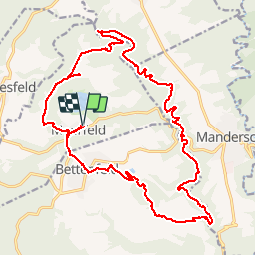
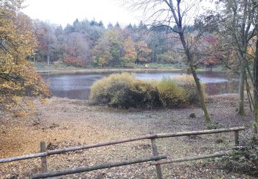
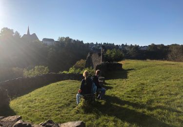
Trail Walking of 22 km to be discovered at Rhineland-Palatinate, Landkreis Bernkastel-Wittlich, Meerfeld. This trail is proposed by flip96.
Description
Rondwandeling Meerfeld (Tour nr. 10 van www.naturaktiverleben.de)Pittige, maar zeer fraaie wandeling.
Opmerkingen? flip96@home.nl
Positioning
Country:
Germany
Region :
Rhineland-Palatinate
Department/Province :
Landkreis Bernkastel-Wittlich
Municipality :
Meerfeld
Location:
Unknown
Start:(Dec)
Start:(UTM)
339714 ; 5551642 (32U) N.
Comments
Trails nearby
![Trail On foot Manderscheid - Manderscheider Burgensteig - Photo](https://media.geolcdn.com/t/375/260/5ac3e765-3be1-4695-9264-ed214577260b.jpeg&format=jpg&maxdim=2)
![On foot On foot](https://static1.geolcdn.com/sitytour/trail-icons/100.png)
Manderscheider Burgensteig
On foot
Easy
Manderscheid,
Rhineland-Palatinate,
Landkreis Bernkastel-Wittlich,
Germany
![](/images/other/stat-length.png)
5.7 km | 8.8 km-effort
2h 0min
![](https://static1.geolcdn.com/siteimages/upload/files/16400158638029165_repeat_loop_refresh_sync_direction_icon.png)
Yes
![Trail Walking Manderscheid - Manderscheid et Mosenberg (Eifel) - Photo](https://media.geolcdn.com/t/375/260/587ebeaa-2ed8-485d-84ac-4ea3053d181c.jpeg&format=jpg&maxdim=2)
![Walking Walking](https://static1.geolcdn.com/sitytour/trail-icons/101.png)
Manderscheid et Mosenberg (Eifel)
Walking
Medium
Manderscheid,
Rhineland-Palatinate,
Landkreis Bernkastel-Wittlich,
Germany
![](/images/other/stat-length.png)
16.4 km | 24 km-effort
5h 30min
![](https://static1.geolcdn.com/siteimages/upload/files/16400158638029165_repeat_loop_refresh_sync_direction_icon.png)
Yes
![Walking Walking](https://static1.geolcdn.com/sitytour/trail-icons/101.png)
Meerfelder Maar en Waldsbornkratersee (PVDB )
Walking
Medium
Meerfeld,
Rhineland-Palatinate,
Landkreis Bernkastel-Wittlich,
Germany
![](/images/other/stat-length.png)
15.9 km | 21 km-effort
4h 16min
![](https://static1.geolcdn.com/siteimages/upload/files/16400158638029165_repeat_loop_refresh_sync_direction_icon.png)
Yes
![Trail Walking Manderscheid - Manderscheid Niederburg - Oberburg - Photo](https://media.geolcdn.com/t/375/260/403961bb-50e8-4f09-a395-f53096d745e4.jpg&format=jpg&maxdim=2)
![Walking Walking](https://static1.geolcdn.com/sitytour/trail-icons/101.png)
Manderscheid Niederburg - Oberburg
Walking
Medium
Manderscheid,
Rhineland-Palatinate,
Landkreis Bernkastel-Wittlich,
Germany
![](/images/other/stat-length.png)
17.8 km | 25 km-effort
3h 42min
![](https://static1.geolcdn.com/siteimages/upload/files/16400158638029165_repeat_loop_refresh_sync_direction_icon.png)
Yes
![Walking Walking](https://static1.geolcdn.com/sitytour/trail-icons/101.png)
2 Manderscheid Burgen
Walking
Medium
Manderscheid,
Rhineland-Palatinate,
Landkreis Bernkastel-Wittlich,
Germany
![](/images/other/stat-length.png)
1.5 km | 2.2 km-effort
30min
![](https://static1.geolcdn.com/siteimages/upload/files/16400158638029165_repeat_loop_refresh_sync_direction_icon.png)
Yes
![Trail Walking Manderscheid - 29 juin boucle-manderscheid-1 - Photo](https://media.geolcdn.com/t/375/260/ext.jpg?maxdim=2&url=https%3A%2F%2Fstatic1.geolcdn.com%2Fsiteimages%2Fupload%2Ffiles%2F1553511878bg_sport_marche.png)
![Walking Walking](https://static1.geolcdn.com/sitytour/trail-icons/101.png)
29 juin boucle-manderscheid-1
Walking
Very difficult
Manderscheid,
Rhineland-Palatinate,
Landkreis Bernkastel-Wittlich,
Germany
![](/images/other/stat-length.png)
24 km | 34 km-effort
7h 42min
![](https://static1.geolcdn.com/siteimages/upload/files/16400158638029165_repeat_loop_refresh_sync_direction_icon.png)
Yes
![Trail Walking Deudesfeld - Autour de Deudesfeld - Photo](https://media.geolcdn.com/t/375/260/ext.jpg?maxdim=2&url=https%3A%2F%2Fstatic1.geolcdn.com%2Fsiteimages%2Fupload%2Ffiles%2F1553511878bg_sport_marche.png)
![Walking Walking](https://static1.geolcdn.com/sitytour/trail-icons/101.png)
Autour de Deudesfeld
Walking
Easy
Deudesfeld,
Rhineland-Palatinate,
Landkreis Vulkaneifel,
Germany
![](/images/other/stat-length.png)
3.9 km | 5 km-effort
1h 11min
![](https://static1.geolcdn.com/siteimages/upload/files/16400158638029165_repeat_loop_refresh_sync_direction_icon.png)
Yes
![Trail Motor Pantenburg - a-duitsland-van-hunsruck-naar-piesport - Photo](https://media.geolcdn.com/t/375/260/ext.jpg?maxdim=2&url=https%3A%2F%2Fstatic1.geolcdn.com%2Fsiteimages%2Fupload%2Ffiles%2F15247431544x4.jpg)
![Motor Motor](https://static1.geolcdn.com/sitytour/trail-icons/400.png)
a-duitsland-van-hunsruck-naar-piesport
Motor
Very easy
Pantenburg,
Rhineland-Palatinate,
Landkreis Bernkastel-Wittlich,
Germany
![](/images/other/stat-length.png)
125 km | 210 km-effort
Unknown
![](https://static1.geolcdn.com/siteimages/upload/files/16400158638029165_repeat_loop_refresh_sync_direction_icon.png)
No
![Trail Mountain bike Manderscheid - m-duitsland-vukaankraterroute - Photo](https://media.geolcdn.com/t/375/260/ext.jpg?maxdim=2&url=https%3A%2F%2Fstatic1.geolcdn.com%2Fsiteimages%2Fupload%2Ffiles%2F1524743154velo.jpg)
![Mountain bike Mountain bike](https://static1.geolcdn.com/sitytour/trail-icons/202.png)
m-duitsland-vukaankraterroute
Mountain bike
Very easy
Manderscheid,
Rhineland-Palatinate,
Landkreis Bernkastel-Wittlich,
Germany
![](/images/other/stat-length.png)
43 km | 57 km-effort
Unknown
![](https://static1.geolcdn.com/siteimages/upload/files/16400158638029165_repeat_loop_refresh_sync_direction_icon.png)
Yes