Trail Walking Eygluy-Escoulin - 130526 Escoulin à Barsac - Photo
 tman
tman

User

© OpenStreetMap contributors
Length
Length
14.9 km
Max alt
Max alt
877 m
Uphill gradient
Uphill gradient
500 m
Km-Effort
Km-Effort  
22 km
Min alt
Min alt
325 m
Downhill gradient
Downhill gradient
602 m
Boucle
Boucle
No
Creation date :
2014-12-10 00:00:00.0
Updated on :
2014-12-10 00:00:00.0

(0 Reviews)

Walking
Walking
4h48
Difficulty : Easy

Scan this QR Code to open this trail in the SityTrail application

FREE GPS app for hiking

Logo SityTrail SityTrail

IGN / Geographical institutes

Download SityTrail from the App Store Download SityTrail from Google Play

Logo SityTrail SityTrail World

The world is yours!

Download SityTrail from the App Store Download SityTrail from Google Play Download SityTrail on Huawei AppGallery

About

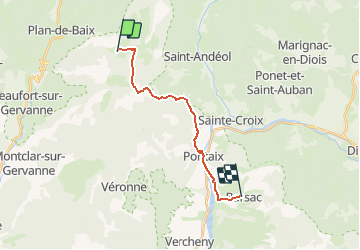
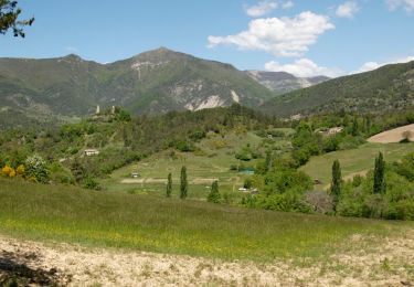
Trail Walking of 14.9 km to be discovered at Auvergne-Rhône-Alpes, Drôme, Eygluy-Escoulin. This trail is proposed by tman.

Description

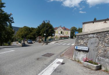
2eme jour vers Die, jusqu'au gite de Mr et Mme Truchefaud, les bruneaux, Barsac. Bon accueil et confort.

Elevation profile

Points of interest

Positioning

Country:
France
Region :
Auvergne-Rhône-Alpes
Department/Province :
Drôme
Municipality :
Eygluy-Escoulin
Location:
Unknown
Start:(UTM)
674395 ; 4963290 (31T) N.

Trails nearby

Trail Walking Eygluy-Escoulin - 26 bec pointu zel 10.11.22 - Photo
Walking
GUIDE
randodyssée

Walking

Medium
(1)
Eygluy-Escoulin, Auvergne-Rhône-Alpes, Drôme, France
12.6 km | 26 km-effort
6h 30min
Yes
Trail Walking Beaufort-sur-Gervanne - 26 gervanne druise plan de baix - Photo
Walking
GUIDE
randodyssée

Walking

Medium
Beaufort-sur-Gervanne, Auvergne-Rhône-Alpes, Drôme, France
16.8 km | 23 km-effort
7h 57min
Yes
Trail Walking Beaufort-sur-Gervanne - Beaufort St Pancrace 17km - Photo
Walking
GUIDE
thonyc

Walking

Medium
(1)
Beaufort-sur-Gervanne, Auvergne-Rhône-Alpes, Drôme, France
15 km | 21 km-effort
5h 0min
Yes
Trail Walking Eygluy-Escoulin - 26 escoulin berches ayes - Photo
Walking
GUIDE
randodyssée

Walking

Medium
Eygluy-Escoulin, Auvergne-Rhône-Alpes, Drôme, France
11.6 km | 25 km-effort
7h 6min
Yes
Trail Walking Saint-Julien-en-Quint - Bec Pointu - Les Glovins - St-Julien-en-Quint - Photo
Walking
Philindy26

Walking

Difficult
Saint-Julien-en-Quint, Auvergne-Rhône-Alpes, Drôme, France
11.5 km | 22 km-effort
5h 40min
Yes
Trail Walking Beaufort-sur-Gervanne - Beaufort - Gigors - Lozeron - Photo
Walking
Philindy26

Walking

Medium
Beaufort-sur-Gervanne, Auvergne-Rhône-Alpes, Drôme, France
18.9 km | 28 km-effort
5h 0min
Yes
Trail Walking Beaufort-sur-Gervanne - BEAUFORT ET GERVANNE - Photo
Walking
Fanchon_24

Walking

Easy
Beaufort-sur-Gervanne, Auvergne-Rhône-Alpes, Drôme, France
36 km | 42 km-effort
4h 8min
No
Trail Walking Eygluy-Escoulin - Le Taillefer - Escoulin-18969835 - Photo
Walking
Philindy26

Walking

Medium
Eygluy-Escoulin, Auvergne-Rhône-Alpes, Drôme, France
8.4 km | 14.1 km-effort
4h 0min
Yes
Trail Walking Plan-de-Baix - Canyon des Gueulards - Plateau du Vellan  - Photo
Walking
Philindy26

Walking

Medium
Plan-de-Baix, Auvergne-Rhône-Alpes, Drôme, France
18.7 km | 28 km-effort
4h 55min
Yes


Close
My subscriptions