![](/images/other/stat-length.png)
![Trail Other activity Zernez - GR / davoser 1. tag - Photo](https://media.geolcdn.com/t/1900/400/ext.pjpeg?maxdim=2&url=https%3A%2F%2Fstatic1.geolcdn.com%2Fsiteimages%2Fupload%2Ffiles%2F1545311037marcheuse_200dpi.jpg)
GR / davoser 1. tag
denisewanderige
User
![Length](/images/other/stat-length.png)
Length
9.2 km
![Max alt](https://static1.geolcdn.com/siteimages/upload/files/1508320355ic_sort_altitude_max_24dp.png)
Max alt
3114 m
![Uphill gradient](https://static1.geolcdn.com/siteimages/upload/files/1508320355ic_sort_den_pos_24dp.png)
Uphill gradient
900 m
![Km-Effort](/images/other/stat-length.png)
Km-Effort
21 km
![Min alt](https://static1.geolcdn.com/siteimages/upload/files/1508320355ic_sort_altitude_min_24dp.png)
Min alt
2327 m
![Downhill gradient](https://static1.geolcdn.com/siteimages/upload/files/1508320355ic_sort_den_neg_24dp.png)
Downhill gradient
700 m
![Boucle](https://static1.geolcdn.com/siteimages/upload/files/16400158638029165_repeat_loop_refresh_sync_direction_icon.png)
Boucle
No
Creation date :
2014-12-11 00:00:00.0
Updated on :
2014-12-11 00:00:00.0
![Other activity](https://static1.geolcdn.com/sitytour/trail-icons/900.png)
--
Difficulty : Unknown
![Scan this QR Code to open this trail in the SityTrail application](https://capi.geolives.com/qq0zvz2zws4bq2lad0pu/sitytour/trails/19502/qr.png?size=200)
FREE GPS app for hiking
About
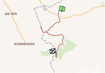
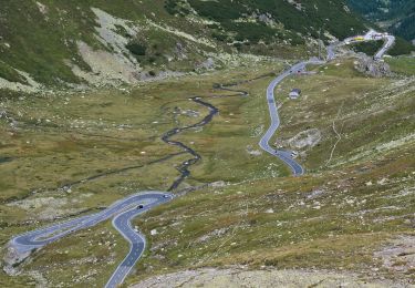
Trail Other activity of 9.2 km to be discovered at Grisons, Region Engiadina Bassa/Val Müstair, Zernez. This trail is proposed by denisewanderige.
Description
Details (Wanderbeschrieb, Fotos, Dauer, Links, usw.) siehe unter:
http://www.wanderige.ch/wanderige_toure/2007/schwarzhorn1/schwarzhorn1.html
Positioning
Country:
Switzerland
Region :
Grisons
Department/Province :
Region Engiadina Bassa/Val Müstair
Municipality :
Zernez
Location:
Unknown
Start:(Dec)
Start:(UTM)
573463 ; 5177188 (32T) N.
Comments
Trails nearby
![Trail On foot Zernez - Flüela-Schwarzhorn - Photo](https://media.geolcdn.com/t/375/260/c812ec15-d96b-4cf6-99f4-739c0b51c7ca.jpeg&format=jpg&maxdim=2)
![On foot On foot](https://static1.geolcdn.com/sitytour/trail-icons/100.png)
Flüela-Schwarzhorn
On foot
Easy
Zernez,
Grisons,
Region Engiadina Bassa/Val Müstair,
Switzerland
![](/images/other/stat-length.png)
3.7 km | 11.3 km-effort
2h 34min
![](https://static1.geolcdn.com/siteimages/upload/files/16400158638029165_repeat_loop_refresh_sync_direction_icon.png)
No
![Trail On foot Zernez - Flüela-Chant Sura - Photo](https://media.geolcdn.com/t/375/260/bbbdd250-a2b0-41cf-93a2-400a7b0858bb.jpeg&format=jpg&maxdim=2)
![On foot On foot](https://static1.geolcdn.com/sitytour/trail-icons/100.png)
Flüela-Chant Sura
On foot
Easy
Zernez,
Grisons,
Region Engiadina Bassa/Val Müstair,
Switzerland
![](/images/other/stat-length.png)
3.1 km | 4 km-effort
54min
![](https://static1.geolcdn.com/siteimages/upload/files/16400158638029165_repeat_loop_refresh_sync_direction_icon.png)
No
![Trail On foot Davos - Tschuggen - Pischa - Photo](https://media.geolcdn.com/t/375/260/7c365420-7f46-437f-8ebd-f88066428055.jpeg&format=jpg&maxdim=2)
![On foot On foot](https://static1.geolcdn.com/sitytour/trail-icons/100.png)
Tschuggen - Pischa
On foot
Easy
Davos,
Grisons,
Prättigau/Davos,
Switzerland
![](/images/other/stat-length.png)
5.3 km | 10.8 km-effort
2h 27min
![](https://static1.geolcdn.com/siteimages/upload/files/16400158638029165_repeat_loop_refresh_sync_direction_icon.png)
No
![Trail Other activity Zernez - y10_davos_schwarzhorn - Photo](https://media.geolcdn.com/t/375/260/ext.jpg?maxdim=2&url=https%3A%2F%2Fstatic1.geolcdn.com%2Fsiteimages%2Fupload%2Ffiles%2F1545311037marcheuse_200dpi.jpg)
![Other activity Other activity](https://static1.geolcdn.com/sitytour/trail-icons/900.png)
y10_davos_schwarzhorn
Other activity
Very easy
Zernez,
Grisons,
Region Engiadina Bassa/Val Müstair,
Switzerland
![](/images/other/stat-length.png)
3.5 km | 11.2 km-effort
2h 43min
![](https://static1.geolcdn.com/siteimages/upload/files/16400158638029165_repeat_loop_refresh_sync_direction_icon.png)
No
![Trail Walking Zernez - huetten_01 - Photo](https://media.geolcdn.com/t/375/260/ext.jpg?maxdim=2&url=https%3A%2F%2Fstatic1.geolcdn.com%2Fsiteimages%2Fupload%2Ffiles%2F1553511878bg_sport_marche.png)
![Walking Walking](https://static1.geolcdn.com/sitytour/trail-icons/101.png)
huetten_01
Walking
Very easy
Zernez,
Grisons,
Region Engiadina Bassa/Val Müstair,
Switzerland
![](/images/other/stat-length.png)
53 km | 90 km-effort
15h 56min
![](https://static1.geolcdn.com/siteimages/upload/files/16400158638029165_repeat_loop_refresh_sync_direction_icon.png)
No
![Trail Walking Davos - YHH094 Schruns à Tirano (4e jour) - Photo](https://media.geolcdn.com/t/375/260/ext.jpg?maxdim=2&url=https%3A%2F%2Fstatic1.geolcdn.com%2Fsiteimages%2Fupload%2Ffiles%2F1553511878bg_sport_marche.png)
![Walking Walking](https://static1.geolcdn.com/sitytour/trail-icons/101.png)
YHH094 Schruns à Tirano (4e jour)
Walking
Very difficult
Davos,
Grisons,
Prättigau/Davos,
Switzerland
![](/images/other/stat-length.png)
19.8 km | 31 km-effort
6h 12min
![](https://static1.geolcdn.com/siteimages/upload/files/16400158638029165_repeat_loop_refresh_sync_direction_icon.png)
No
![Trail Other activity Zernez - GR / davoser 2. tag - Photo](https://media.geolcdn.com/t/375/260/ext.jpg?maxdim=2&url=https%3A%2F%2Fstatic1.geolcdn.com%2Fsiteimages%2Fupload%2Ffiles%2F1545311037marcheuse_200dpi.jpg)
![Other activity Other activity](https://static1.geolcdn.com/sitytour/trail-icons/900.png)
GR / davoser 2. tag
Other activity
Very easy
Zernez,
Grisons,
Region Engiadina Bassa/Val Müstair,
Switzerland
![](/images/other/stat-length.png)
15.5 km | 27 km-effort
Unknown
![](https://static1.geolcdn.com/siteimages/upload/files/16400158638029165_repeat_loop_refresh_sync_direction_icon.png)
No
![Trail Other activity Davos - GR / wägerhus - jörisee - klosters - tag 1 - Photo](https://media.geolcdn.com/t/375/260/ext.jpg?maxdim=2&url=https%3A%2F%2Fstatic1.geolcdn.com%2Fsiteimages%2Fupload%2Ffiles%2F1545311037marcheuse_200dpi.jpg)
![Other activity Other activity](https://static1.geolcdn.com/sitytour/trail-icons/900.png)
GR / wägerhus - jörisee - klosters - tag 1
Other activity
Very easy
Davos,
Grisons,
Prättigau/Davos,
Switzerland
![](/images/other/stat-length.png)
9.8 km | 18.4 km-effort
Unknown
![](https://static1.geolcdn.com/siteimages/upload/files/16400158638029165_repeat_loop_refresh_sync_direction_icon.png)
No