![](/images/other/stat-length.png)
![Trail Walking Hellenthal - Hellenthal-Oleftalsperre - Photo](https://media.geolcdn.com/t/1900/400/ext.pjpeg?maxdim=2&url=https%3A%2F%2Fstatic1.geolcdn.com%2Fsiteimages%2Fupload%2Ffiles%2F1553511878bg_sport_marche.png)
Hellenthal-Oleftalsperre
flip96
User
![Length](/images/other/stat-length.png)
Length
18 km
![Max alt](https://static1.geolcdn.com/siteimages/upload/files/1508320355ic_sort_altitude_max_24dp.png)
Max alt
619 m
![Uphill gradient](https://static1.geolcdn.com/siteimages/upload/files/1508320355ic_sort_den_pos_24dp.png)
Uphill gradient
447 m
![Km-Effort](/images/other/stat-length.png)
Km-Effort
24 km
![Min alt](https://static1.geolcdn.com/siteimages/upload/files/1508320355ic_sort_altitude_min_24dp.png)
Min alt
403 m
![Downhill gradient](https://static1.geolcdn.com/siteimages/upload/files/1508320355ic_sort_den_neg_24dp.png)
Downhill gradient
449 m
![Boucle](https://static1.geolcdn.com/siteimages/upload/files/16400158638029165_repeat_loop_refresh_sync_direction_icon.png)
Boucle
Yes
Creation date :
2014-12-10 00:00:00.0
Updated on :
2014-12-10 00:00:00.0
![Walking](https://static1.geolcdn.com/sitytour/trail-icons/101.png)
5h05
Difficulty : Medium
![Scan this QR Code to open this trail in the SityTrail application](https://capi.geolives.com/qq0zvz2zws4bq2lad0pu/sitytour/trails/193117/qr.png?size=200)
FREE GPS app for hiking
About
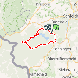
Trail Walking of 18 km to be discovered at North Rhine-Westphalia, Kreis Euskirchen, Hellenthal. This trail is proposed by flip96.
Description
Rondwandeling 18km. vanaf parkeerplaats Wildfreigehege, om Oleftalsperre naar Hellenthal.
Veel asfalt!
Opmerkingen? flip96@home.nl
Positioning
Country:
Germany
Region :
North Rhine-Westphalia
Department/Province :
Kreis Euskirchen
Municipality :
Hellenthal
Location:
Unknown
Start:(Dec)
Start:(UTM)
317739 ; 5597653 (32U) N.
Comments
Trails nearby
![Trail On foot Schleiden - Dreiborn 5 - Photo](https://media.geolcdn.com/t/375/260/a4584be8-207b-429b-b13b-4225de0a89c1.jpeg&format=jpg&maxdim=2)
![On foot On foot](https://static1.geolcdn.com/sitytour/trail-icons/100.png)
Dreiborn 5
On foot
Easy
Schleiden,
North Rhine-Westphalia,
Kreis Euskirchen,
Germany
![](/images/other/stat-length.png)
9.9 km | 13.1 km-effort
2h 58min
![](https://static1.geolcdn.com/siteimages/upload/files/16400158638029165_repeat_loop_refresh_sync_direction_icon.png)
Yes
![Trail On foot Hellenthal - Hellenthal Rundweg 9 - Photo](https://media.geolcdn.com/t/375/260/799f075a-274f-4aef-beec-202054a576ab.jpeg&format=jpg&maxdim=2)
![On foot On foot](https://static1.geolcdn.com/sitytour/trail-icons/100.png)
Hellenthal Rundweg 9
On foot
Easy
Hellenthal,
North Rhine-Westphalia,
Kreis Euskirchen,
Germany
![](/images/other/stat-length.png)
3.4 km | 4.9 km-effort
1h 7min
![](https://static1.geolcdn.com/siteimages/upload/files/16400158638029165_repeat_loop_refresh_sync_direction_icon.png)
No
![Trail On foot Hellenthal - Eisvogelpfad - Photo](https://media.geolcdn.com/t/375/260/a9a363d7-7e92-4aa3-8076-f4b43602021c.jpeg&format=jpg&maxdim=2)
![On foot On foot](https://static1.geolcdn.com/sitytour/trail-icons/100.png)
Eisvogelpfad
On foot
Easy
Hellenthal,
North Rhine-Westphalia,
Kreis Euskirchen,
Germany
![](/images/other/stat-length.png)
13.8 km | 17.3 km-effort
3h 56min
![](https://static1.geolcdn.com/siteimages/upload/files/16400158638029165_repeat_loop_refresh_sync_direction_icon.png)
Yes
![Trail On foot Schleiden - Schleiden 4 - Photo](https://media.geolcdn.com/t/375/260/8211feec-fa9b-40b5-bf41-71727ea2bd2e.jpeg&format=jpg&maxdim=2)
![On foot On foot](https://static1.geolcdn.com/sitytour/trail-icons/100.png)
Schleiden 4
On foot
Easy
Schleiden,
North Rhine-Westphalia,
Kreis Euskirchen,
Germany
![](/images/other/stat-length.png)
4.7 km | 6.9 km-effort
1h 34min
![](https://static1.geolcdn.com/siteimages/upload/files/16400158638029165_repeat_loop_refresh_sync_direction_icon.png)
No
![Trail On foot Hellenthal - Hellenthal Rundweg 10 - Photo](https://media.geolcdn.com/t/375/260/a9a363d7-7e92-4aa3-8076-f4b43602021c.jpeg&format=jpg&maxdim=2)
![On foot On foot](https://static1.geolcdn.com/sitytour/trail-icons/100.png)
Hellenthal Rundweg 10
On foot
Easy
Hellenthal,
North Rhine-Westphalia,
Kreis Euskirchen,
Germany
![](/images/other/stat-length.png)
3.9 km | 5 km-effort
1h 7min
![](https://static1.geolcdn.com/siteimages/upload/files/16400158638029165_repeat_loop_refresh_sync_direction_icon.png)
No
![Trail On foot Schleiden - Schleiden Wanderweg 6 - Photo](https://media.geolcdn.com/t/375/260/8211feec-fa9b-40b5-bf41-71727ea2bd2e.jpeg&format=jpg&maxdim=2)
![On foot On foot](https://static1.geolcdn.com/sitytour/trail-icons/100.png)
Schleiden Wanderweg 6
On foot
Easy
Schleiden,
North Rhine-Westphalia,
Kreis Euskirchen,
Germany
![](/images/other/stat-length.png)
9.7 km | 12.7 km-effort
2h 53min
![](https://static1.geolcdn.com/siteimages/upload/files/16400158638029165_repeat_loop_refresh_sync_direction_icon.png)
No
![Trail On foot Hellenthal - Hellenthal Rundweg 12 - Photo](https://media.geolcdn.com/t/375/260/662c7290-2de6-4fc1-b631-863be5a625f3.jpeg&format=jpg&maxdim=2)
![On foot On foot](https://static1.geolcdn.com/sitytour/trail-icons/100.png)
Hellenthal Rundweg 12
On foot
Easy
Hellenthal,
North Rhine-Westphalia,
Kreis Euskirchen,
Germany
![](/images/other/stat-length.png)
6.3 km | 8.4 km-effort
1h 55min
![](https://static1.geolcdn.com/siteimages/upload/files/16400158638029165_repeat_loop_refresh_sync_direction_icon.png)
No
![Trail On foot Hellenthal - Hellenthal R 1 - Photo](https://media.geolcdn.com/t/375/260/3e325507-9b86-4182-88ca-13f8c337bb50.jpeg&format=jpg&maxdim=2)
![On foot On foot](https://static1.geolcdn.com/sitytour/trail-icons/100.png)
Hellenthal R 1
On foot
Easy
Hellenthal,
North Rhine-Westphalia,
Kreis Euskirchen,
Germany
![](/images/other/stat-length.png)
12.9 km | 16.2 km-effort
3h 40min
![](https://static1.geolcdn.com/siteimages/upload/files/16400158638029165_repeat_loop_refresh_sync_direction_icon.png)
No
![Trail On foot Schleiden - Schöneseiffen 3 - Photo](https://media.geolcdn.com/t/375/260/ext.jpg?maxdim=2&url=https%3A%2F%2Fstatic1.geolcdn.com%2Fsiteimages%2Fupload%2Ffiles%2F1545311037marcheuse_200dpi.jpg)
![On foot On foot](https://static1.geolcdn.com/sitytour/trail-icons/100.png)
Schöneseiffen 3
On foot
Easy
Schleiden,
North Rhine-Westphalia,
Kreis Euskirchen,
Germany
![](/images/other/stat-length.png)
3.5 km | 4.9 km-effort
1h 6min
![](https://static1.geolcdn.com/siteimages/upload/files/16400158638029165_repeat_loop_refresh_sync_direction_icon.png)
No