![](/images/other/stat-length.png)
![Trail Winter sports Grindelwald - Eiger Bike - Photo](https://media.geolcdn.com/t/1900/400/ext.pjpeg?maxdim=2&url=https%3A%2F%2Fstatic1.geolcdn.com%2Fsiteimages%2Fupload%2Ffiles%2F1524743153ski.jpg)
Eiger Bike
remo
User
![Length](/images/other/stat-length.png)
Length
53 km
![Max alt](https://static1.geolcdn.com/siteimages/upload/files/1508320355ic_sort_altitude_max_24dp.png)
Max alt
2161 m
![Uphill gradient](https://static1.geolcdn.com/siteimages/upload/files/1508320355ic_sort_den_pos_24dp.png)
Uphill gradient
2615 m
![Km-Effort](/images/other/stat-length.png)
Km-Effort
87 km
![Min alt](https://static1.geolcdn.com/siteimages/upload/files/1508320355ic_sort_altitude_min_24dp.png)
Min alt
935 m
![Downhill gradient](https://static1.geolcdn.com/siteimages/upload/files/1508320355ic_sort_den_neg_24dp.png)
Downhill gradient
2523 m
![Boucle](https://static1.geolcdn.com/siteimages/upload/files/16400158638029165_repeat_loop_refresh_sync_direction_icon.png)
Boucle
No
Creation date :
2014-12-11 00:00:00.0
Updated on :
2014-12-11 00:00:00.0
![Winter sports](https://static1.geolcdn.com/sitytour/trail-icons/500.png)
--
Difficulty : Unknown
![Scan this QR Code to open this trail in the SityTrail application](https://capi.geolives.com/qq0zvz2zws4bq2lad0pu/sitytour/trails/19253/qr.png?size=200)
FREE GPS app for hiking
About
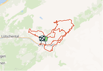
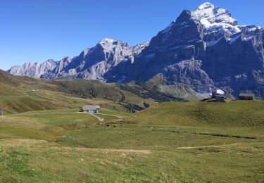
Trail Winter sports of 53 km to be discovered at Bern, Interlaken-Oberhasli administrative district, Grindelwald. This trail is proposed by remo.
Description
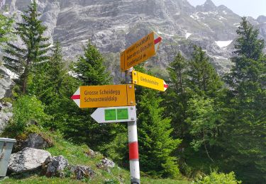
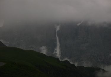
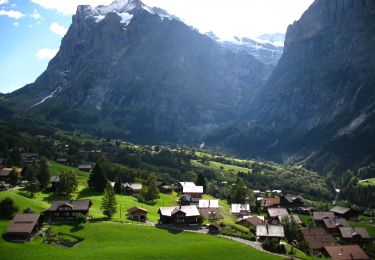
6. Eiger Bike Challenge, Grindelwald
Hinweis: Die Trackdaten können auf http://www.remosworld.ch gratis gedownloadet werden.
Positioning
Country:
Switzerland
Region :
Bern
Department/Province :
Interlaken-Oberhasli administrative district
Municipality :
Grindelwald
Location:
Unknown
Start:(Dec)
Start:(UTM)
425104 ; 5163821 (32T) N.
Comments
Trails nearby
![Trail On foot Grindelwald - CH-Unterlauchbühl - Bort - Photo](https://media.geolcdn.com/t/375/260/917b7bc8-fc63-4bb4-ac37-b5bc1f4152ab.jpeg&format=jpg&maxdim=2)
![On foot On foot](https://static1.geolcdn.com/sitytour/trail-icons/100.png)
CH-Unterlauchbühl - Bort
On foot
Easy
Grindelwald,
Bern,
Interlaken-Oberhasli administrative district,
Switzerland
![](/images/other/stat-length.png)
4.2 km | 7 km-effort
1h 35min
![](https://static1.geolcdn.com/siteimages/upload/files/16400158638029165_repeat_loop_refresh_sync_direction_icon.png)
No
![Trail On foot Grindelwald - Bachalpsee - Oberläger - Faulhorn - Photo](https://media.geolcdn.com/t/375/260/f62b1a84-1970-4e32-afcd-65dd14db1ded.jpeg&format=jpg&maxdim=2)
![On foot On foot](https://static1.geolcdn.com/sitytour/trail-icons/100.png)
Bachalpsee - Oberläger - Faulhorn
On foot
Easy
Grindelwald,
Bern,
Interlaken-Oberhasli administrative district,
Switzerland
![](/images/other/stat-length.png)
7.7 km | 16.5 km-effort
3h 45min
![](https://static1.geolcdn.com/siteimages/upload/files/16400158638029165_repeat_loop_refresh_sync_direction_icon.png)
No
![Trail On foot Grindelwald - Holewang - fixme - Photo](https://media.geolcdn.com/t/375/260/c1fd772a-1ad4-4009-8d2b-3788115972fd.jpeg&format=jpg&maxdim=2)
![On foot On foot](https://static1.geolcdn.com/sitytour/trail-icons/100.png)
Holewang - fixme
On foot
Easy
Grindelwald,
Bern,
Interlaken-Oberhasli administrative district,
Switzerland
![](/images/other/stat-length.png)
5.1 km | 7.5 km-effort
1h 41min
![](https://static1.geolcdn.com/siteimages/upload/files/16400158638029165_repeat_loop_refresh_sync_direction_icon.png)
No
![Trail Walking Grindelwald - Lacs de Bashsee - Photo](https://media.geolcdn.com/t/375/260/c1b7e7ed-052e-4a42-8881-0cf2a67a243c.jpg&format=jpg&maxdim=2)
![Walking Walking](https://static1.geolcdn.com/sitytour/trail-icons/101.png)
Lacs de Bashsee
Walking
Medium
Grindelwald,
Bern,
Interlaken-Oberhasli administrative district,
Switzerland
![](/images/other/stat-length.png)
11.4 km | 16.9 km-effort
3h 15min
![](https://static1.geolcdn.com/siteimages/upload/files/16400158638029165_repeat_loop_refresh_sync_direction_icon.png)
Yes
![Trail Other activity Grindelwald - ViaRegio_Jungfrau_4 - Photo](https://media.geolcdn.com/t/375/260/ext.jpg?maxdim=2&url=https%3A%2F%2Fstatic1.geolcdn.com%2Fsiteimages%2Fupload%2Ffiles%2F1545311037marcheuse_200dpi.jpg)
![Other activity Other activity](https://static1.geolcdn.com/sitytour/trail-icons/900.png)
ViaRegio_Jungfrau_4
Other activity
Very easy
Grindelwald,
Bern,
Interlaken-Oberhasli administrative district,
Switzerland
![](/images/other/stat-length.png)
17.9 km | 34 km-effort
7h 30min
![](https://static1.geolcdn.com/siteimages/upload/files/16400158638029165_repeat_loop_refresh_sync_direction_icon.png)
No
![Trail Walking Grindelwald - Grindelwald: Rollstuhlgängiges Gipfelpanorama - Photo](https://media.geolcdn.com/t/375/260/ext.jpg?maxdim=2&url=https%3A%2F%2Fstatic1.geolcdn.com%2Fsiteimages%2Fupload%2Ffiles%2F1553511878bg_sport_marche.png)
![Walking Walking](https://static1.geolcdn.com/sitytour/trail-icons/101.png)
Grindelwald: Rollstuhlgängiges Gipfelpanorama
Walking
Very easy
Grindelwald,
Bern,
Interlaken-Oberhasli administrative district,
Switzerland
![](/images/other/stat-length.png)
4.8 km | 5.8 km-effort
Unknown
![](https://static1.geolcdn.com/siteimages/upload/files/16400158638029165_repeat_loop_refresh_sync_direction_icon.png)
No
![Trail Mountain bike Grindelwald - Bike32892 - Photo](https://media.geolcdn.com/t/375/260/ext.jpg?maxdim=2&url=https%3A%2F%2Fstatic1.geolcdn.com%2Fsiteimages%2Fupload%2Ffiles%2F1524743154velo.jpg)
![Mountain bike Mountain bike](https://static1.geolcdn.com/sitytour/trail-icons/202.png)
Bike32892
Mountain bike
Very easy
Grindelwald,
Bern,
Interlaken-Oberhasli administrative district,
Switzerland
![](/images/other/stat-length.png)
38 km | 56 km-effort
Unknown
![](https://static1.geolcdn.com/siteimages/upload/files/16400158638029165_repeat_loop_refresh_sync_direction_icon.png)
No
![Trail Walking Lauterbrunnen - st_eigertrail - Photo](https://media.geolcdn.com/t/375/260/ext.jpg?maxdim=2&url=https%3A%2F%2Fstatic1.geolcdn.com%2Fsiteimages%2Fupload%2Ffiles%2F1553511878bg_sport_marche.png)
![Walking Walking](https://static1.geolcdn.com/sitytour/trail-icons/101.png)
st_eigertrail
Walking
Very easy
Lauterbrunnen,
Bern,
Interlaken-Oberhasli administrative district,
Switzerland
![](/images/other/stat-length.png)
7.3 km | 12.9 km-effort
Unknown
![](https://static1.geolcdn.com/siteimages/upload/files/16400158638029165_repeat_loop_refresh_sync_direction_icon.png)
No
![Trail Walking Lauterbrunnen - Kleine Scheidegg - Eigergletsche- Wengeralp - Photo](https://media.geolcdn.com/t/375/260/2b8f7ae3-634d-4097-a2ba-b20e35d11fa6.jpg&format=jpg&maxdim=2)
![Walking Walking](https://static1.geolcdn.com/sitytour/trail-icons/101.png)
Kleine Scheidegg - Eigergletsche- Wengeralp
Walking
Medium
Lauterbrunnen,
Bern,
Interlaken-Oberhasli administrative district,
Switzerland
![](/images/other/stat-length.png)
7.4 km | 11.7 km-effort
2h 14min
![](https://static1.geolcdn.com/siteimages/upload/files/16400158638029165_repeat_loop_refresh_sync_direction_icon.png)
No