Trail Walking Gresse-en-Vercors - Vercors (4) - Photo
 frizou83
frizou83

User

© OpenStreetMap contributors
Length
Length
9.8 km
Max alt
Max alt
1673 m
Uphill gradient
Uphill gradient
697 m
Km-Effort
Km-Effort  
19.1 km
Min alt
Min alt
1013 m
Downhill gradient
Downhill gradient
696 m
Boucle
Boucle
Yes
Creation date :
2014-12-10 00:00:00.0
Updated on :
2014-12-10 00:00:00.0

(0 Reviews)

Walking
Walking
4h28
Difficulty : Medium

Scan this QR Code to open this trail in the SityTrail application

FREE GPS app for hiking

Logo SityTrail SityTrail

IGN / Geographical institutes

Download SityTrail from the App Store Download SityTrail from Google Play

Logo SityTrail SityTrail World

The world is yours!

Download SityTrail from the App Store Download SityTrail from Google Play Download SityTrail on Huawei AppGallery

About

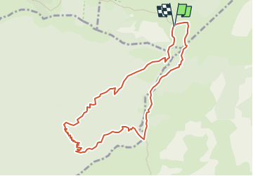
Trail Walking of 9.8 km to be discovered at Auvergne-Rhône-Alpes, Isère, Gresse-en-Vercors. This trail is proposed by frizou83.

Description

Ballade autour de la cabane de Pré Peyret (fort dénivelé)

Elevation profile

Positioning

Country:
France
Region :
Auvergne-Rhône-Alpes
Department/Province :
Isère
Municipality :
Gresse-en-Vercors
Location:
Unknown
Start:(Dec)
Start:(UTM)
696271 ; 4966724 (31T) N.

Trails nearby

Trail Walking Gresse-en-Vercors - traversée Sud nord du Grand Veymont  - Photo
Walking
GUIDE
nadd73

Walking

Difficult
Gresse-en-Vercors, Auvergne-Rhône-Alpes, Isère, France
26 km | 40 km-effort
10h 42min
No
Trail Walking Saint-Agnan-en-Vercors - jour 1 Sommet de Peyre rouge  - Photo
Walking
GUIDE
nadd73

Walking

Medium
Saint-Agnan-en-Vercors, Auvergne-Rhône-Alpes, Drôme, France
13.7 km | 23 km-effort
5h 7min
No
Trail Walking Chichilianne - 14923554-Tour du Mont Aiguille - Photo
Walking
Maryma

Walking

Very difficult
(1)
Chichilianne, Auvergne-Rhône-Alpes, Isère, France
17.7 km | 33 km-effort
7h 27min
Yes
Trail Walking Romeyer - La rive du rocher des heures - Photo
Walking
GUIDE
nadd73

Walking

Difficult
Romeyer, Auvergne-Rhône-Alpes, Drôme, France
19.5 km | 34 km-effort
5h 31min
No
Trail Walking Romeyer - les rochers de plautret - Photo
Walking
bymarc26

Walking

Difficult
(2)
Romeyer, Auvergne-Rhône-Alpes, Drôme, France
14.2 km | 27 km-effort
6h 40min
Yes
Trail Walking Chichilianne - Diois 2024 1ère journée  - Photo
Walking
planets

Walking

Medium
Chichilianne, Auvergne-Rhône-Alpes, Isère, France
22 km | 35 km-effort
4h 59min
No
Trail Walking Romeyer - Romeyer - Col des Bachassons - Le Pison - Le Château - Photo
Walking
Philindy26

Walking

Difficult
Romeyer, Auvergne-Rhône-Alpes, Drôme, France
15.6 km | 28 km-effort
5h 30min
Yes
Trail Walking Romeyer - Tourte-Barreaux  - Photo
Walking
ajd26

Walking

Difficult
Romeyer, Auvergne-Rhône-Alpes, Drôme, France
18.2 km | 32 km-effort
7h 12min
Yes
Trail Snowshoes Saint-Agnan-en-Vercors - Rousset-Plateau de Beure 7,5km - Photo
Snowshoes
GUIDE
thonyc

Snowshoes

Medium
Saint-Agnan-en-Vercors, Auvergne-Rhône-Alpes, Drôme, France
7.3 km | 11.5 km-effort
4h 30min
Yes


Close
My subscriptions