![](/images/other/stat-length.png)
![Trail Walking Obersteinbach - Wasigenstein Obersteinbach - Photo](https://media.geolcdn.com/t/1900/400/ext.pjpeg?maxdim=2&url=https%3A%2F%2Fservices.sitytrail.com%2FGeolivesWS%2FDownloadMedia.ashx%3FTrailID%3D191633%26Media%3D15275_6.jpg)
Wasigenstein Obersteinbach
tracegps
User
![Length](/images/other/stat-length.png)
![Max alt](https://static1.geolcdn.com/siteimages/upload/files/1508320355ic_sort_altitude_max_24dp.png)
![Uphill gradient](https://static1.geolcdn.com/siteimages/upload/files/1508320355ic_sort_den_pos_24dp.png)
![Km-Effort](/images/other/stat-length.png)
![Min alt](https://static1.geolcdn.com/siteimages/upload/files/1508320355ic_sort_altitude_min_24dp.png)
![Downhill gradient](https://static1.geolcdn.com/siteimages/upload/files/1508320355ic_sort_den_neg_24dp.png)
![Boucle](https://static1.geolcdn.com/siteimages/upload/files/16400158638029165_repeat_loop_refresh_sync_direction_icon.png)
![Walking](https://static1.geolcdn.com/sitytour/trail-icons/101.png)
3h45
Difficulty : Medium
![Scan this QR Code to open this trail in the SityTrail application](https://capi.geolives.com/qq0zvz2zws4bq2lad0pu/sitytour/trails/191633/qr.png?size=200)
FREE GPS app for hiking
About
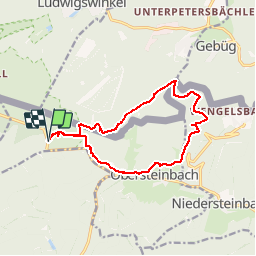
Trail Walking of 12.6 km to be discovered at Grand Est, Bas-Rhin, Obersteinbach. This trail is proposed by tracegps.
Description
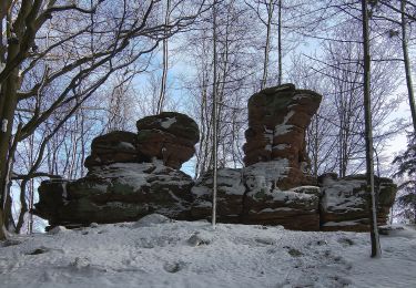
Départ au parking forestier près D3. Le chemin traverse la «Réserve biologique domaniale intégrale et transfrontalière», 400ha, créée par l’ONF pour étudier et comprendre le fonctionnement naturel d’une forêt sans intervention humaine. Monter au château de Lutzelhardt et revenir sur ses pas. Arrivé à la vallée du Steinbach, tourner à gauche vers la frontière allemande. Montée vers le rocher du Bayerischer Windstein : un des plus beaux panoramas sur les Vosges du Nord depuis la plateforme accessible par une échelle. Continuer vers le château de Wasigenstein où il est possible de faire un arrêt repas, tiré du sac. Descendre vers le Wolfsfels et remonter vers le château de Petit-Arnsbourg. Puis traverser le village alsacien d'Obersteinbach. Environ 200 m après la maison forestière de Lutzelhardt, tourner à gauche et revenir au parking de départ.
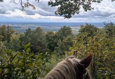
Positioning
Comments
Trails nearby
![Trail Horseback riding Obersteinbach - suuntoapp-HorsebackRiding-2024-10-01T07-38-54Z - Photo](https://media.geolcdn.com/t/375/260/7049fffa-9fd0-4a27-8d60-6425b502499f.jpg&format=jpg&maxdim=2)
![Horseback riding Horseback riding](https://static1.geolcdn.com/sitytour/trail-icons/301.png)
Horseback riding
![](/images/other/stat-length.png)
![](https://static1.geolcdn.com/siteimages/upload/files/16400158638029165_repeat_loop_refresh_sync_direction_icon.png)
![Trail Horseback riding Obersteinbach - suuntoapp-HorsebackRiding-2024-09-30T07-27-07Z - Photo](https://media.geolcdn.com/t/375/260/a81589e8-b3fb-4376-a4c5-155adc86d091.jpg&format=jpg&maxdim=2)
![Horseback riding Horseback riding](https://static1.geolcdn.com/sitytour/trail-icons/301.png)
Horseback riding
![](/images/other/stat-length.png)
![](https://static1.geolcdn.com/siteimages/upload/files/16400158638029165_repeat_loop_refresh_sync_direction_icon.png)
![Trail Horseback riding Schönau (Pfalz) - suuntoapp-HorsebackRiding-2024-09-29T07-15-12Z - Photo](https://media.geolcdn.com/t/375/260/8b46bdbb-d46a-437e-9444-a15a461aae7b.jpg&format=jpg&maxdim=2)
![Horseback riding Horseback riding](https://static1.geolcdn.com/sitytour/trail-icons/301.png)
Horseback riding
![](/images/other/stat-length.png)
![](https://static1.geolcdn.com/siteimages/upload/files/16400158638029165_repeat_loop_refresh_sync_direction_icon.png)
![Trail On foot Sturzelbronn - Autour des moines de Sturzelbronn - Photo](https://media.geolcdn.com/t/375/260/caf7594f-14b2-48e2-8398-22008e31622f.jpeg&format=jpg&maxdim=2)
![On foot On foot](https://static1.geolcdn.com/sitytour/trail-icons/100.png)
On foot
![](/images/other/stat-length.png)
![](https://static1.geolcdn.com/siteimages/upload/files/16400158638029165_repeat_loop_refresh_sync_direction_icon.png)
![Trail On foot Niedersteinbach - Losange jaune - Photo](https://media.geolcdn.com/t/375/260/9750e9c7-d771-48fb-9dc8-91b6e4088834.jpeg&format=jpg&maxdim=2)
![On foot On foot](https://static1.geolcdn.com/sitytour/trail-icons/100.png)
On foot
![](/images/other/stat-length.png)
![](https://static1.geolcdn.com/siteimages/upload/files/16400158638029165_repeat_loop_refresh_sync_direction_icon.png)
![Trail On foot Niedersteinbach - Anneau jaune - Photo](https://media.geolcdn.com/t/375/260/864ec68b-7e8c-46d6-8de7-bd04be428ab9.jpeg&format=jpg&maxdim=2)
![On foot On foot](https://static1.geolcdn.com/sitytour/trail-icons/100.png)
On foot
![](/images/other/stat-length.png)
![](https://static1.geolcdn.com/siteimages/upload/files/16400158638029165_repeat_loop_refresh_sync_direction_icon.png)
![Trail On foot Obersteinbach - Anneau jaune - Photo](https://media.geolcdn.com/t/375/260/c13c2c58-10d7-439e-a51f-7bf0b0ed9b4d.jpeg&format=jpg&maxdim=2)
![On foot On foot](https://static1.geolcdn.com/sitytour/trail-icons/100.png)
On foot
![](/images/other/stat-length.png)
![](https://static1.geolcdn.com/siteimages/upload/files/16400158638029165_repeat_loop_refresh_sync_direction_icon.png)
![Trail On foot Obersteinbach - Triangle rouge - Photo](https://media.geolcdn.com/t/375/260/fff2d3ea-92b0-447d-8719-9088e8932805.jpeg&format=jpg&maxdim=2)
![On foot On foot](https://static1.geolcdn.com/sitytour/trail-icons/100.png)
On foot
![](/images/other/stat-length.png)
![](https://static1.geolcdn.com/siteimages/upload/files/16400158638029165_repeat_loop_refresh_sync_direction_icon.png)
![Trail On foot Sturzelbronn - Scenic cross-border trail No. 3 - Photo](https://media.geolcdn.com/t/375/260/9a7ba633-a867-49a1-a146-4bd2e867222a.jpeg&format=jpg&maxdim=2)
![On foot On foot](https://static1.geolcdn.com/sitytour/trail-icons/100.png)
On foot
![](/images/other/stat-length.png)
![](https://static1.geolcdn.com/siteimages/upload/files/16400158638029165_repeat_loop_refresh_sync_direction_icon.png)