![](/images/other/stat-length.png)
![Trail Snowshoes Saint-Amarin - Traversée des Vosges en raquettes - Étape 1 - de Saint Amarin au Grand Ballon - Photo](https://media.geolcdn.com/t/1900/400/ext.pjpeg?maxdim=2&url=https%3A%2F%2Fservices.sitytrail.com%2FGeolivesWS%2FDownloadMedia.ashx%3FTrailID%3D191444%26Media%3D15032_1.jpg)
Traversée des Vosges en raquettes - Étape 1 - de Saint Amarin au Grand Ballon
tracegps
User
![Length](/images/other/stat-length.png)
![Max alt](https://static1.geolcdn.com/siteimages/upload/files/1508320355ic_sort_altitude_max_24dp.png)
![Uphill gradient](https://static1.geolcdn.com/siteimages/upload/files/1508320355ic_sort_den_pos_24dp.png)
![Km-Effort](/images/other/stat-length.png)
![Min alt](https://static1.geolcdn.com/siteimages/upload/files/1508320355ic_sort_altitude_min_24dp.png)
![Downhill gradient](https://static1.geolcdn.com/siteimages/upload/files/1508320355ic_sort_den_neg_24dp.png)
![Boucle](https://static1.geolcdn.com/siteimages/upload/files/16400158638029165_repeat_loop_refresh_sync_direction_icon.png)
![Snowshoes](https://static1.geolcdn.com/sitytour/trail-icons/504.png)
3h30
Difficulty : Difficult
![Scan this QR Code to open this trail in the SityTrail application](https://capi.geolives.com/qq0zvz2zws4bq2lad0pu/sitytour/trails/191444/qr.png?size=200)
FREE GPS app for hiking
About
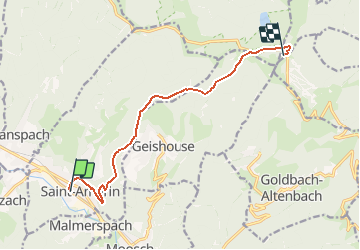
Trail Snowshoes of 9.5 km to be discovered at Grand Est, Haut-Rhin, Saint-Amarin. This trail is proposed by tracegps.
Description
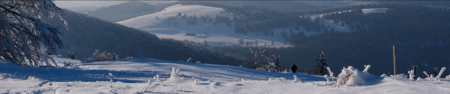
Cette randonnée de 115 km environ se découpant en 7 étapes (de 15 à 20 km au maximum) est une traversée des Vosges sud/nord qui débute à Saint-Amarin, dans la vallée de Thann et se termine à Sainte-Marie-aux-Mines. Elle a été prévue pour être effectuée en hiver avec des raquettes. En raison de l'effort majoré et des journées assez courtes, les étapes prévues n'étaient pas très ambitieuses. Cette randonnée peut aussi être faite durant les autres saisons sans problèmes. Première étape. Lundi 18 février 2013. Nous arrivons par le train. Volontairement, l’étape d’aujourd’hui est courte. C’est, comme on dit, une étape de mise en jambe. Le temps est magnifique. Nous respectons l’itinéraire prévu. Montée au Col du Haag par un sentier bien balisé et enneigé. Deux kilomètres à peine après le départ, nous devons chausser les crampons, moins fatigants que les raquettes, car la neige est dure et l’on n’y enfonce pas. Col du Haag où la ferme auberge est, contre toute attente, ouverte, et pour finir un petit bout de la route des crêtes non déneigée, transformée en piste de ski de fond qui mène au châlet-refuge du Grand Ballon en une demi-heure. Il reste encore assez de temps pour monter au sommet et aller admirer les sommets des Alpes bernoises flottant sur un radeau de brume. Pour plus d’informations, retrouvez les conseils pratiques sur cette randonnée.
Positioning
Comments
Trails nearby
![Trail On foot Bitschwiller-lès-Thann - Bitschwiller les Thann - Rehbrunnel - Abri du Becherkopf - Roche Albert - Photo](https://media.geolcdn.com/t/375/260/ext.jpg?maxdim=2&url=https%3A%2F%2Fstatic1.geolcdn.com%2Fsiteimages%2Fupload%2Ffiles%2F1545311037marcheuse_200dpi.jpg)
![On foot On foot](https://static1.geolcdn.com/sitytour/trail-icons/100.png)
On foot
![](/images/other/stat-length.png)
![](https://static1.geolcdn.com/siteimages/upload/files/16400158638029165_repeat_loop_refresh_sync_direction_icon.png)
![Trail Walking Oderen - TREK ALSACIEN (boucle, la meute) - Photo](https://media.geolcdn.com/t/375/260/bce13479-4ed1-47a7-a848-8fc9fefb1457.jpg&format=jpg&maxdim=2)
![Walking Walking](https://static1.geolcdn.com/sitytour/trail-icons/101.png)
Walking
![](/images/other/stat-length.png)
![](https://static1.geolcdn.com/siteimages/upload/files/16400158638029165_repeat_loop_refresh_sync_direction_icon.png)
![Trail Walking Oderen - Oderen Bergenbach Langenbach - Photo](https://media.geolcdn.com/t/375/260/05163254-f106-4300-b7bd-e85eb3e624ac.jpg&format=jpg&maxdim=2)
![Walking Walking](https://static1.geolcdn.com/sitytour/trail-icons/101.png)
Walking
![](/images/other/stat-length.png)
![](https://static1.geolcdn.com/siteimages/upload/files/16400158638029165_repeat_loop_refresh_sync_direction_icon.png)
![Trail Walking Mollau - Le rossberg - Photo](https://media.geolcdn.com/t/375/260/e1c84c66-d799-45c0-a7df-12e4ffcf0bb2.jpg&format=jpg&maxdim=2)
![Walking Walking](https://static1.geolcdn.com/sitytour/trail-icons/101.png)
![Trail Walking Oderen - TREK ALSACIEN (1ère étape) - Photo](https://media.geolcdn.com/t/375/260/787fe892-71a8-4daf-8eb0-6ad69c3ebb22.jpg&format=jpg&maxdim=2)
![Walking Walking](https://static1.geolcdn.com/sitytour/trail-icons/101.png)
Walking
![](/images/other/stat-length.png)
![](https://static1.geolcdn.com/siteimages/upload/files/16400158638029165_repeat_loop_refresh_sync_direction_icon.png)
![Trail Walking Ranspach - Rando des Marcheurs 20/07/2023 - Photo](https://media.geolcdn.com/t/375/260/e65497d0-16d3-4e63-993c-c9f6fe260f85.jpg&format=jpg&maxdim=2)
![Walking Walking](https://static1.geolcdn.com/sitytour/trail-icons/101.png)
Walking
![](/images/other/stat-length.png)
![](https://static1.geolcdn.com/siteimages/upload/files/16400158638029165_repeat_loop_refresh_sync_direction_icon.png)
![Trail Walking Saint-Amarin - dimanche - Photo](https://media.geolcdn.com/t/375/260/ext.jpg?maxdim=2&url=https%3A%2F%2Fstatic1.geolcdn.com%2Fsiteimages%2Fupload%2Ffiles%2F1553511878bg_sport_marche.png)
![Walking Walking](https://static1.geolcdn.com/sitytour/trail-icons/101.png)
Walking
![](/images/other/stat-length.png)
![](https://static1.geolcdn.com/siteimages/upload/files/16400158638029165_repeat_loop_refresh_sync_direction_icon.png)
![Trail Walking Moosch - Moosch Haag - Photo](https://media.geolcdn.com/t/375/260/ext.jpg?maxdim=2&url=https%3A%2F%2Fstatic1.geolcdn.com%2Fsiteimages%2Fupload%2Ffiles%2F1553511878bg_sport_marche.png)
![Walking Walking](https://static1.geolcdn.com/sitytour/trail-icons/101.png)
Walking
![](/images/other/stat-length.png)
![](https://static1.geolcdn.com/siteimages/upload/files/16400158638029165_repeat_loop_refresh_sync_direction_icon.png)
![Trail Walking Oderen - TREK ALSACIEN (boucle, Odin) - Photo](https://media.geolcdn.com/t/375/260/dddd2487-4fb8-4cef-bf36-6235f5cea729.jpg&format=jpg&maxdim=2)
![Walking Walking](https://static1.geolcdn.com/sitytour/trail-icons/101.png)
Walking
![](/images/other/stat-length.png)
![](https://static1.geolcdn.com/siteimages/upload/files/16400158638029165_repeat_loop_refresh_sync_direction_icon.png)