Trail Mountain bike Castellane - Espace VTT - FFC du Verdon et des Vallées de l'Asse - Le Tour de Destourbes    n°3 - Castellane - Photo

Espace VTT - FFC du Verdon et des Vallées de l'Asse - Le Tour de Destourbes  n°3 - Castellane

 tracegps
tracegps

User

© OpenStreetMap contributors
Length
Length
22 km
Max alt
Max alt
1172 m
Uphill gradient
Uphill gradient
654 m
Km-Effort
Km-Effort  
30 km
Min alt
Min alt
721 m
Downhill gradient
Downhill gradient
654 m
Boucle
Boucle
Yes
Creation date :
2014-12-10 00:00:00.0
Updated on :
2014-12-10 00:00:00.0

(0 Reviews)

Mountain bike
Mountain bike
2h30
Difficulty : Very difficult

Scan this QR Code to open this trail in the SityTrail application

FREE GPS app for hiking

Logo SityTrail SityTrail

IGN / Geographical institutes

Download SityTrail from the App Store Download SityTrail from Google Play

Logo SityTrail SityTrail World

The world is yours!

Download SityTrail from the App Store Download SityTrail from Google Play Download SityTrail on Huawei AppGallery

About

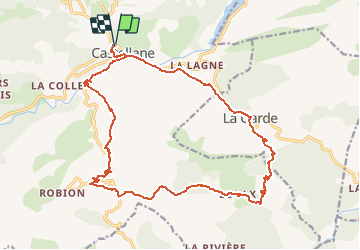
Trail Mountain bike of 22 km to be discovered at Provence-Alpes-Côte d'Azur, Alpes-de-Haute-Provence, Castellane. This trail is proposed by tracegps.

Description

Circuit proposé par l'Espace VTT - FFC du Verdon et des Vallées de l'Asse et la Communauté de Communes du Moyen Verdon. Circuit officiel labellisé par la Fédération Française de Cyclisme. Départ du parking du boulevard St Michel à Castellane. Parcours très sportif autour de la montagne de Destourbes permettant de découvrir la chapelle Saint Thyrs, classée monument historique, le hameau préservé d'Eoulx et le petit village de La Garde. Retour par le célèbre GR4 à partir de La Garde.

Elevation profile

Photos

Positioning

Country:
France
Region :
Provence-Alpes-Côte d'Azur
Department/Province :
Alpes-de-Haute-Provence
Municipality :
Castellane
Location:
Unknown
Start:(Dec)
Start:(UTM)
299915 ; 4857980 (32T) N.

Trails nearby

Trail Walking Castellane - Sentier des Siréniens  - Photo
Walking
Dervalmarc

Walking

Very easy
(1)
Castellane, Provence-Alpes-Côte d'Azur, Alpes-de-Haute-Provence, France
3.8 km | 5.5 km-effort
1h 9min
Yes
Trail Walking Castellane - cadiere de brandis - Photo
Walking
choux83

Walking

Very easy
(1)
Castellane, Provence-Alpes-Côte d'Azur, Alpes-de-Haute-Provence, France
8.9 km | 14.6 km-effort
2h 27min
No
Trail Mountain bike Castellane - vtt-de-castellane-au-lac-de-castillon - Photo
Mountain bike
GUIDE
pascalou73

Mountain bike

Very easy
Castellane, Provence-Alpes-Côte d'Azur, Alpes-de-Haute-Provence, France
14.7 km | 19.5 km-effort
Unknown
Yes
Trail Walking Castellane - Cadières de Brandis - Photo
Walking
jmheydorff

Walking

Medium
(1)
Castellane, Provence-Alpes-Côte d'Azur, Alpes-de-Haute-Provence, France
10.7 km | 18.4 km-effort
3h 51min
Yes
Trail Walking Castellane - castellane - Photo
Walking
RoMo

Walking

Medium
Castellane, Provence-Alpes-Côte d'Azur, Alpes-de-Haute-Provence, France
4.7 km | 8 km-effort
1h 26min
Yes
Trail Walking Castellane - La Colle : Cadières de Brandis - Photo
Walking
ETMU5496

Walking

Difficult
Castellane, Provence-Alpes-Côte d'Azur, Alpes-de-Haute-Provence, France
17.5 km | 30 km-effort
6h 54min
Yes
Trail Walking Demandolx - Demandolx cremon 1000m 16kms  - Photo
Walking
GUIDE
Danielba

Walking

Very difficult
Demandolx, Provence-Alpes-Côte d'Azur, Alpes-de-Haute-Provence, France
14.8 km | 27 km-effort
8h 5min
Yes
Trail Walking Castellane - Thyrs : sommet du Robion - Photo
Walking
ETMU5496

Walking

Difficult
Castellane, Provence-Alpes-Côte d'Azur, Alpes-de-Haute-Provence, France
14.6 km | 28 km-effort
6h 16min
Yes
Trail Walking Castellane - robion castellane 1226m 15k - Photo
Walking
GUIDE
Danielba

Walking

Very difficult
Castellane, Provence-Alpes-Côte d'Azur, Alpes-de-Haute-Provence, France
13.9 km | 27 km-effort
7h 50min
Yes


Close
My subscriptions