![](/images/other/stat-length.png)
![Trail Walking Marseille - Le Sommet de Marseilleveyre, par le Pas de la Cabre - Photo](https://media.geolcdn.com/t/1900/400/ext.pjpeg?maxdim=2&url=https%3A%2F%2Fservices.sitytrail.com%2FGeolivesWS%2FDownloadMedia.ashx%3FTrailID%3D191416%26Media%3D14997_1.jpg)
Le Sommet de Marseilleveyre, par le Pas de la Cabre
tracegps
User
![Length](/images/other/stat-length.png)
![Max alt](https://static1.geolcdn.com/siteimages/upload/files/1508320355ic_sort_altitude_max_24dp.png)
![Uphill gradient](https://static1.geolcdn.com/siteimages/upload/files/1508320355ic_sort_den_pos_24dp.png)
![Km-Effort](/images/other/stat-length.png)
![Min alt](https://static1.geolcdn.com/siteimages/upload/files/1508320355ic_sort_altitude_min_24dp.png)
![Downhill gradient](https://static1.geolcdn.com/siteimages/upload/files/1508320355ic_sort_den_neg_24dp.png)
![Boucle](https://static1.geolcdn.com/siteimages/upload/files/16400158638029165_repeat_loop_refresh_sync_direction_icon.png)
![Walking](https://static1.geolcdn.com/sitytour/trail-icons/101.png)
4h15
Difficulty : Difficult
![Scan this QR Code to open this trail in the SityTrail application](https://capi.geolives.com/qq0zvz2zws4bq2lad0pu/sitytour/trails/191416/qr.png?size=200)
FREE GPS app for hiking
About
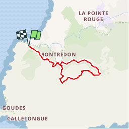
Trail Walking of 6.4 km to be discovered at Provence-Alpes-Côte d'Azur, Bouches-du-Rhône, Marseille. This trail is proposed by tracegps.
Description
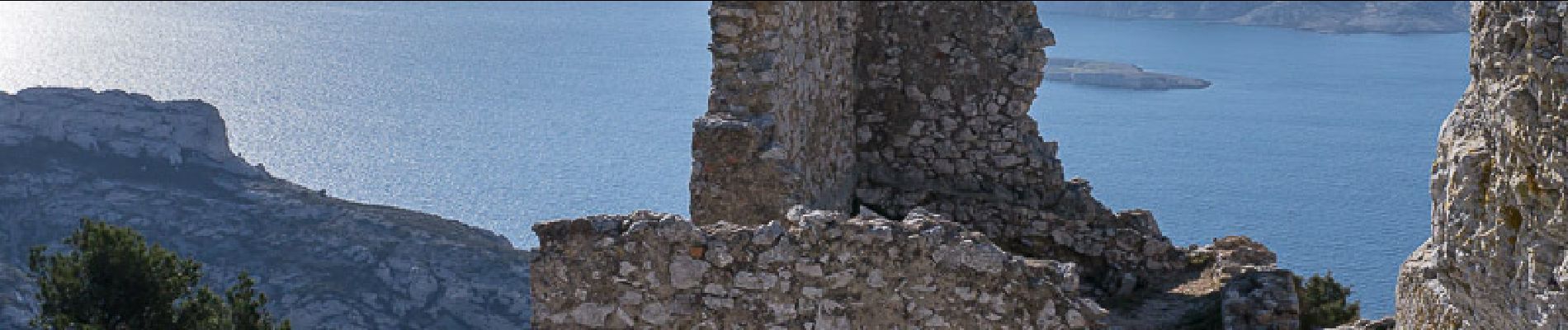
Depuis Montredon, un itinéraire pittoresque peut être dessiné pour atteindre le Sommet de Marseilleveyre. Il visite le site surprenant de la Roche Percée, remonte le beau et sauvage Vallon des Aiguilles pour franchir le Pas de la Cabre et atteindre le Col des Chèvres. Suit ensuite un superbe parcours aérien pour traverser le Sommet de Marseilleveyre et rejoindre le Col de la Selle. Après un paisible et agréable parcours sous le couvert forestier du Bois de la Selle, une courte ascension permet de retrouver l'itinéraire de départ sous la Roche Percée. Description complète sur sentier-nature.com : Le Sommet de Marseilleveyre, par le Pas de la Cabre Avertissement [Franchissement 3/3 ; Exposition 1/3 ; Pénibilité 2/3]. Certains passages de cet itinéraire de montagne sont escarpés et/ou exposés, il est déconseillé aux enfants non accompagnés et aux personnes sujettes au vertige. Pour votre sécurité, nous vous invitons à respecter les règles suivantes : être bien chaussé, ne pas s'engager par mauvais temps, ne pas s'écarter de l'itinéraire ni des sentiers.
Positioning
Comments
Trails nearby
![Trail Mountain bike Marseille - OR-6270829--Marseille:Trilogie des Calanques - Photo](https://media.geolcdn.com/t/375/260/37b85b5c-5918-4ab9-a017-9d4bcff1fa49.jpg&format=jpg&maxdim=2)
![Mountain bike Mountain bike](https://static1.geolcdn.com/sitytour/trail-icons/202.png)
Mountain bike
![](/images/other/stat-length.png)
![](https://static1.geolcdn.com/siteimages/upload/files/16400158638029165_repeat_loop_refresh_sync_direction_icon.png)
![Trail Walking Marseille - Marseilleveyre - Photo](https://media.geolcdn.com/t/375/260/1c6dd8e4-fc3d-455d-ab0a-aecb3f4e28f3.jpg&format=jpg&maxdim=2)
![Walking Walking](https://static1.geolcdn.com/sitytour/trail-icons/101.png)
Walking
![](/images/other/stat-length.png)
![](https://static1.geolcdn.com/siteimages/upload/files/16400158638029165_repeat_loop_refresh_sync_direction_icon.png)
![Trail On foot Marseille - FR-4 - Photo](https://media.geolcdn.com/t/375/260/95b4ab9b-15fa-4206-9283-bece755bce28.jpeg&format=jpg&maxdim=2)
![On foot On foot](https://static1.geolcdn.com/sitytour/trail-icons/100.png)
On foot
![](/images/other/stat-length.png)
![](https://static1.geolcdn.com/siteimages/upload/files/16400158638029165_repeat_loop_refresh_sync_direction_icon.png)
![Trail On foot Marseille - FR-1 - Photo](https://media.geolcdn.com/t/375/260/bc3bf1c1-4e6d-4ecd-b741-b7754447ebb3.jpeg&format=jpg&maxdim=2)
![On foot On foot](https://static1.geolcdn.com/sitytour/trail-icons/100.png)
On foot
![](/images/other/stat-length.png)
![](https://static1.geolcdn.com/siteimages/upload/files/16400158638029165_repeat_loop_refresh_sync_direction_icon.png)
![Trail On foot Marseille - FR-1 - Photo](https://media.geolcdn.com/t/375/260/99184d8a-cb78-4a50-b5ed-c50326639dce.jpeg&format=jpg&maxdim=2)
![On foot On foot](https://static1.geolcdn.com/sitytour/trail-icons/100.png)
On foot
![](/images/other/stat-length.png)
![](https://static1.geolcdn.com/siteimages/upload/files/16400158638029165_repeat_loop_refresh_sync_direction_icon.png)
![Trail On foot Marseille - FR-1 - Photo](https://media.geolcdn.com/t/375/260/bc3bf1c1-4e6d-4ecd-b741-b7754447ebb3.jpeg&format=jpg&maxdim=2)
![On foot On foot](https://static1.geolcdn.com/sitytour/trail-icons/100.png)
On foot
![](/images/other/stat-length.png)
![](https://static1.geolcdn.com/siteimages/upload/files/16400158638029165_repeat_loop_refresh_sync_direction_icon.png)
![Trail On foot Marseille - FR-1 - Photo](https://media.geolcdn.com/t/375/260/4cd62a7f-c9ca-4a0b-a61b-53cee5136735.jpeg&format=jpg&maxdim=2)
![On foot On foot](https://static1.geolcdn.com/sitytour/trail-icons/100.png)
On foot
![](/images/other/stat-length.png)
![](https://static1.geolcdn.com/siteimages/upload/files/16400158638029165_repeat_loop_refresh_sync_direction_icon.png)
![Trail On foot Marseille - FR-2 - Photo](https://media.geolcdn.com/t/375/260/4e6398b1-8b18-413e-9aa3-3eda435bcb35.jpeg&format=jpg&maxdim=2)
![On foot On foot](https://static1.geolcdn.com/sitytour/trail-icons/100.png)
On foot
![](/images/other/stat-length.png)
![](https://static1.geolcdn.com/siteimages/upload/files/16400158638029165_repeat_loop_refresh_sync_direction_icon.png)
![Trail On foot Marseille - FR-2 - Photo](https://media.geolcdn.com/t/375/260/95b4ab9b-15fa-4206-9283-bece755bce28.jpeg&format=jpg&maxdim=2)
![On foot On foot](https://static1.geolcdn.com/sitytour/trail-icons/100.png)
On foot
![](/images/other/stat-length.png)
![](https://static1.geolcdn.com/siteimages/upload/files/16400158638029165_repeat_loop_refresh_sync_direction_icon.png)