![](/images/other/stat-length.png)
![Trail Walking Senez - La Voie Impériale (Etape 2 : Senez - Chaudon-Norante (La Clappe)) - Photo](https://media.geolcdn.com/t/1900/400/ext.pjpeg?maxdim=2&url=https%3A%2F%2Fservices.sitytrail.com%2FGeolivesWS%2FDownloadMedia.ashx%3FTrailID%3D191398%26Media%3D14973_3.jpg)
La Voie Impériale (Etape 2 : Senez - Chaudon-Norante (La Clappe))
tracegps
User
![Length](/images/other/stat-length.png)
![Max alt](https://static1.geolcdn.com/siteimages/upload/files/1508320355ic_sort_altitude_max_24dp.png)
![Uphill gradient](https://static1.geolcdn.com/siteimages/upload/files/1508320355ic_sort_den_pos_24dp.png)
![Km-Effort](/images/other/stat-length.png)
![Min alt](https://static1.geolcdn.com/siteimages/upload/files/1508320355ic_sort_altitude_min_24dp.png)
![Downhill gradient](https://static1.geolcdn.com/siteimages/upload/files/1508320355ic_sort_den_neg_24dp.png)
![Boucle](https://static1.geolcdn.com/siteimages/upload/files/16400158638029165_repeat_loop_refresh_sync_direction_icon.png)
![Walking](https://static1.geolcdn.com/sitytour/trail-icons/101.png)
6h00
Difficulty : Difficult
![Scan this QR Code to open this trail in the SityTrail application](https://capi.geolives.com/qq0zvz2zws4bq2lad0pu/sitytour/trails/191398/qr.png?size=200)
FREE GPS app for hiking
About
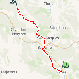
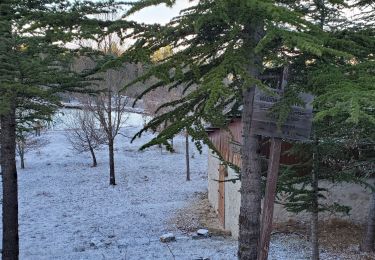
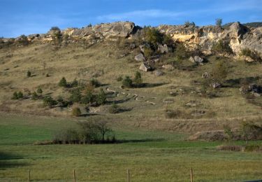
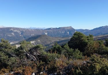
Trail Walking of 19.5 km to be discovered at Provence-Alpes-Côte d'Azur, Alpes-de-Haute-Provence, Senez. This trail is proposed by tracegps.
Description
Le 26 février 1815, Napoléon quitte l’île d’Elbe, débarque à Golfe Juan le 1er mars et gagne Paris, avec ses hommes, le 20 mars 1815. Il traverse Castellane et Digne-les-Bains les 3 et 4 mars 1815. Ce cheminement historique a donné lieu à la création d'un itinéraire de randonnée thématique unique en France : la Voie Impériale, reliant Castellane et Digne-les-Bains sur une distance de 52 km. La randonnée qui peut s’effectuer à pied ou à cheval (cavalier confirmé), permet de traverser des paysages encore vierges et authentiques de la Haute Provence et de découvrir un patrimoine remarquable au fil des étapes. Retrouvez la voie Impériale sur le site de la Communauté de Communes du Moyen Verdon.
Positioning
Comments
Trails nearby
![Trail Walking Barrême - 18-10-2022 Pied Marcelin - Château plus haut - Photo](https://media.geolcdn.com/t/375/260/95321ed0-8bdf-4371-8c77-b796551d86e3.jpg&format=jpg&maxdim=2)
![Walking Walking](https://static1.geolcdn.com/sitytour/trail-icons/101.png)
Walking
![](/images/other/stat-length.png)
![](https://static1.geolcdn.com/siteimages/upload/files/16400158638029165_repeat_loop_refresh_sync_direction_icon.png)
![Trail Walking Senez - SENEZ , clue de la Melle. , chapelle de la Melle , o s - Photo](https://media.geolcdn.com/t/375/260/65810687-8f9e-42d8-af58-1816ae33fe23.jpg&format=jpg&maxdim=2)
![Walking Walking](https://static1.geolcdn.com/sitytour/trail-icons/101.png)
Walking
![](/images/other/stat-length.png)
![](https://static1.geolcdn.com/siteimages/upload/files/16400158638029165_repeat_loop_refresh_sync_direction_icon.png)
![Trail On foot Barrême - Gévaudan - Photo](https://media.geolcdn.com/t/375/260/ext.jpg?maxdim=2&url=https%3A%2F%2Fstatic1.geolcdn.com%2Fsiteimages%2Fupload%2Ffiles%2F1545311037marcheuse_200dpi.jpg)
![On foot On foot](https://static1.geolcdn.com/sitytour/trail-icons/100.png)
On foot
![](/images/other/stat-length.png)
![](https://static1.geolcdn.com/siteimages/upload/files/16400158638029165_repeat_loop_refresh_sync_direction_icon.png)
![Trail Walking Blieux - blieux les trois moures 1087m 18kms - Photo](https://media.geolcdn.com/t/375/260/d127b13b-6828-4952-9438-6bce22421610.jpg&format=jpg&maxdim=2)
![Walking Walking](https://static1.geolcdn.com/sitytour/trail-icons/101.png)
Walking
![](/images/other/stat-length.png)
![](https://static1.geolcdn.com/siteimages/upload/files/16400158638029165_repeat_loop_refresh_sync_direction_icon.png)
![Trail Walking Barrême - barrême chateau plus haut chaudon 19.5km 860m - Photo](https://media.geolcdn.com/t/375/260/84d893d5-e67c-4bae-9aa3-757788e39a80.jpg&format=jpg&maxdim=2)
![Walking Walking](https://static1.geolcdn.com/sitytour/trail-icons/101.png)
Walking
![](/images/other/stat-length.png)
![](https://static1.geolcdn.com/siteimages/upload/files/16400158638029165_repeat_loop_refresh_sync_direction_icon.png)
![Trail Walking Barrême - Barrême pariounne 16kms 900m - Photo](https://media.geolcdn.com/t/375/260/ba49b43d-0f1d-46c3-8dc6-a2963af4d2e0.jpg&format=jpg&maxdim=2)
![Walking Walking](https://static1.geolcdn.com/sitytour/trail-icons/101.png)
Walking
![](/images/other/stat-length.png)
![](https://static1.geolcdn.com/siteimages/upload/files/16400158638029165_repeat_loop_refresh_sync_direction_icon.png)
![Trail Mountain bike Barrême - Espace VTT - FFC du Verdon et des Vallées de l'Asse - Le Tour de Lieye n°15 - Barrême - Photo](https://media.geolcdn.com/t/375/260/ext.jpg?maxdim=2&url=https%3A%2F%2Fservices.sitytrail.com%2FGeolivesWS%2FDownloadMedia.ashx%3FTrailID%3D191439%26Media%3D15027_3.jpg)
![Mountain bike Mountain bike](https://static1.geolcdn.com/sitytour/trail-icons/202.png)
Mountain bike
![](/images/other/stat-length.png)
![](https://static1.geolcdn.com/siteimages/upload/files/16400158638029165_repeat_loop_refresh_sync_direction_icon.png)
![Trail Equestrian Senez - La Voie Impériale (Etape 2 : Senez - Chaudon-Norante (La Clappe)) - Photo](https://media.geolcdn.com/t/375/260/ext.jpg?maxdim=2&url=https%3A%2F%2Fservices.sitytrail.com%2FGeolivesWS%2FDownloadMedia.ashx%3FTrailID%3D191399%26Media%3D14973_6.jpg)
![Equestrian Equestrian](https://static1.geolcdn.com/sitytour/trail-icons/300.png)
Equestrian
![](/images/other/stat-length.png)
![](https://static1.geolcdn.com/siteimages/upload/files/16400158638029165_repeat_loop_refresh_sync_direction_icon.png)
![Trail Walking Barrême - Crete de La Parrioune - Photo](https://media.geolcdn.com/t/375/260/be5c4476-1865-49f7-b711-47f573030b3d.jpg&format=jpg&maxdim=2)
![Walking Walking](https://static1.geolcdn.com/sitytour/trail-icons/101.png)
Walking
![](/images/other/stat-length.png)
![](https://static1.geolcdn.com/siteimages/upload/files/16400158638029165_repeat_loop_refresh_sync_direction_icon.png)