Trail Running La Crau - Le Fenouillet - La Crau    - Photo

Le Fenouillet - La Crau

 tracegps
tracegps

User

© OpenStreetMap contributors
Length
Length
10.4 km
Max alt
Max alt
233 m
Uphill gradient
Uphill gradient
360 m
Km-Effort
Km-Effort  
15.2 km
Min alt
Min alt
39 m
Downhill gradient
Downhill gradient
360 m
Boucle
Boucle
Yes
Creation date :
2014-12-10 00:00:00.0
Updated on :
2014-12-10 00:00:00.0

(0 Reviews)

Running
Running
1h19
Difficulty : Difficult

Scan this QR Code to open this trail in the SityTrail application

FREE GPS app for hiking

Logo SityTrail SityTrail

IGN / Geographical institutes

Download SityTrail from the App Store Download SityTrail from Google Play

Logo SityTrail SityTrail World

The world is yours!

Download SityTrail from the App Store Download SityTrail from Google Play Download SityTrail on Huawei AppGallery

About

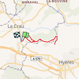
Trail Running of 10.4 km to be discovered at Provence-Alpes-Côte d'Azur, Var, La Crau. This trail is proposed by tracegps.

Description

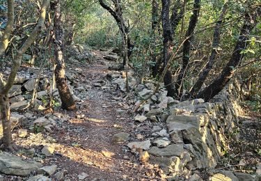
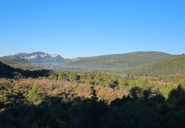
Départ au croisement de la D 76 et D 554, au sud de La Crau. Bon petit parcours à faire après une bonne journée de taf, que du single en forêt et de la bonne grimpette !!!!

Elevation profile

Photos

Positioning

Country:
France
Region :
Provence-Alpes-Côte d'Azur
Department/Province :
Var
Municipality :
La Crau
Location:
Unknown
Start:(UTM)
262518 ; 4780171 (32T) N.

Trails nearby

Trail Walking La Crau - fenouillet Daniel Louis - Photo
Walking
cdanielrando

Walking

Medium
(1)
La Crau, Provence-Alpes-Côte d'Azur, Var, France
18.1 km | 25 km-effort
4h 36min
Yes
Trail Walking La Crau - le fenouillet un après-midi d'automne  - Photo
Walking
le.noceur

Walking

Easy
(2)
La Crau, Provence-Alpes-Côte d'Azur, Var, France
7.6 km | 10.7 km-effort
1h 48min
Yes
Trail Trail La Crau - Le Fenouillet et château d' Hyères  - Photo
Trail
GUIDE
nadd73

Trail

Medium
La Crau, Provence-Alpes-Côte d'Azur, Var, France
13.1 km | 18.8 km-effort
2h 9min
No
Trail Walking La Crau - Fenouillet - Chateau de Hyères - retour par les vignes - Photo
Walking
GUIDE
affinetataille

Walking

Medium
(2)
La Crau, Provence-Alpes-Côte d'Azur, Var, France
14.1 km | 19.7 km-effort
5h 0min
Yes
Trail Walking Le Pradet - SityTrail - le Pradet les trois forts - Photo
Walking
GUIDE
affinetataille

Walking

Very difficult
(1)
Le Pradet, Provence-Alpes-Côte d'Azur, Var, France
13.3 km | 19.6 km-effort
4h 27min
Yes
Trail On foot Le Pradet - le pradet plage de la garonne la mine - Photo
On foot
chrifor

On foot

Easy
(1)
Le Pradet, Provence-Alpes-Côte d'Azur, Var, France
6.1 km | 8.2 km-effort
Unknown
Yes
Trail Walking La Farlède - De La farlède vers le sommet du Mont Coudon, puis retour par le petit Coudon - Photo
Walking
FSantoni

Walking

Very difficult
La Farlède, Provence-Alpes-Côte d'Azur, Var, France
14.1 km | 22 km-effort
6h 55min
Yes
Trail Walking Solliès-Ville - Domaine de la Castille-20-09-2024 - Photo
Walking
Christiancordin

Walking

Easy
Solliès-Ville, Provence-Alpes-Côte d'Azur, Var, France
6.3 km | 7 km-effort
1h 37min
Yes
Trail Walking La Farlède - La farlède-Tourris - Photo
Walking
FSantoni

Walking

Very difficult
La Farlède, Provence-Alpes-Côte d'Azur, Var, France
16 km | 23 km-effort
6h 36min
Yes


Close
My subscriptions