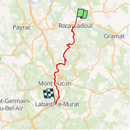
![](/images/other/stat-length.png)
![Trail Walking Rocamadour - La Via Arverna (Rocamadour - Labastide-Murat) - Photo](https://media.geolcdn.com/t/1900/400/ext.pjpeg?maxdim=2&url=https%3A%2F%2Fservices.sitytrail.com%2FGeolivesWS%2FDownloadMedia.ashx%3FTrailID%3D191360%26Media%3D14925_6.jpg)
La Via Arverna (Rocamadour - Labastide-Murat)
tracegps
User
![Length](/images/other/stat-length.png)
![Max alt](https://static1.geolcdn.com/siteimages/upload/files/1508320355ic_sort_altitude_max_24dp.png)
![Uphill gradient](https://static1.geolcdn.com/siteimages/upload/files/1508320355ic_sort_den_pos_24dp.png)
![Km-Effort](/images/other/stat-length.png)
![Min alt](https://static1.geolcdn.com/siteimages/upload/files/1508320355ic_sort_altitude_min_24dp.png)
![Downhill gradient](https://static1.geolcdn.com/siteimages/upload/files/1508320355ic_sort_den_neg_24dp.png)
![Boucle](https://static1.geolcdn.com/siteimages/upload/files/16400158638029165_repeat_loop_refresh_sync_direction_icon.png)
![Walking](https://static1.geolcdn.com/sitytour/trail-icons/101.png)
7h30
Difficulty : Difficult
![Scan this QR Code to open this trail in the SityTrail application](https://capi.geolives.com/qq0zvz2zws4bq2lad0pu/sitytour/trails/191360/qr.png?size=200)
FREE GPS app for hiking
About
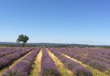
Trail Walking of 26 km to be discovered at Occitania, Lot, Rocamadour. This trail is proposed by tracegps.
Description
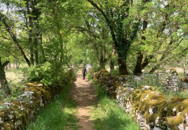
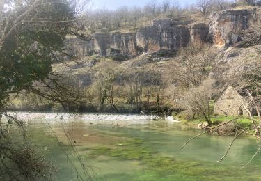
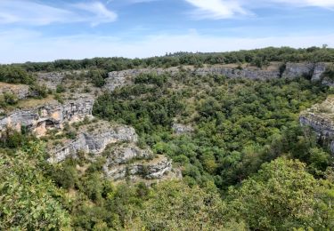
Etape 18 de la Via Arverna, chemin de Saint Jacques de Compostelle entre Clermont-Ferrand et Cahors. « A partir de cette étape, les randonneurs suivront le balisage de la GR 46 qui les mènera à destination de Labastide-Murat. Franchissement de la vallée de l’Alzou et passage par des prairies, sous-bois et quelques villages. L’arrivée aura lieu dans le village de Labastide-Murat, porte d’entrée du parc régional du Quercy. Au cours de cette étape, vous croiserez fréquemment les moutons à lunettes noire. » Retrouvez l'étape n° 18 sur le site de la «Via Arverna - chemin Saint-Jacques-de-Compostelle» ainsi qu'ICI sur le site de la « Via Arverna ».
Positioning
Comments
Trails nearby
![Trail Walking Rocamadour - Col de mages Lafage Rocamadour La Panonie - Photo](https://media.geolcdn.com/t/375/260/9f4a7e91-ac8d-4857-be4f-8e26f11cf7f3.jpg&format=jpg&maxdim=2)
![Walking Walking](https://static1.geolcdn.com/sitytour/trail-icons/101.png)
Walking
![](/images/other/stat-length.png)
![](https://static1.geolcdn.com/siteimages/upload/files/16400158638029165_repeat_loop_refresh_sync_direction_icon.png)
![Trail Walking Alvignac - Le grand tour d'Alvignac Les Eaux - Photo](https://media.geolcdn.com/t/375/260/ext.jpg?maxdim=2&url=https%3A%2F%2Fservices.sitytrail.com%2FGeolivesWS%2FDownloadMedia.ashx%3FTrailID%3D111869%26Media%3D8685_4.jpg)
![Walking Walking](https://static1.geolcdn.com/sitytour/trail-icons/101.png)
Walking
![](/images/other/stat-length.png)
![](https://static1.geolcdn.com/siteimages/upload/files/16400158638029165_repeat_loop_refresh_sync_direction_icon.png)
![Trail Walking Calès - Cougnaguet Rocamadour - Photo](https://media.geolcdn.com/t/375/260/add75687-554b-4d45-a34f-d79f204e2b9d.jpg&format=jpg&maxdim=2)
![Walking Walking](https://static1.geolcdn.com/sitytour/trail-icons/101.png)
Walking
![](/images/other/stat-length.png)
![](https://static1.geolcdn.com/siteimages/upload/files/16400158638029165_repeat_loop_refresh_sync_direction_icon.png)
![Trail Walking Gramat - Moulin du saut - Photo](https://media.geolcdn.com/t/375/260/81ea1c7f-a2c4-42fc-9927-d2aa00c3944a.jpg&format=jpg&maxdim=2)
![Walking Walking](https://static1.geolcdn.com/sitytour/trail-icons/101.png)
![Trail Walking Calès - Cales lacave cougnaguet - Photo](https://media.geolcdn.com/t/375/260/79e6908b-86b7-4f2f-b896-312926c7edab.jpg&format=jpg&maxdim=2)
![Walking Walking](https://static1.geolcdn.com/sitytour/trail-icons/101.png)
Walking
![](/images/other/stat-length.png)
![](https://static1.geolcdn.com/siteimages/upload/files/16400158638029165_repeat_loop_refresh_sync_direction_icon.png)
![Trail On foot Rocamadour - Boucle de randonnée entre Rocamadour et le Gouffre de Padirac - Photo](https://media.geolcdn.com/t/375/260/80b0432d-439e-456c-9615-ea85758f11af.jpeg&format=jpg&maxdim=2)
![On foot On foot](https://static1.geolcdn.com/sitytour/trail-icons/100.png)
On foot
![](/images/other/stat-length.png)
![](https://static1.geolcdn.com/siteimages/upload/files/16400158638029165_repeat_loop_refresh_sync_direction_icon.png)
![Walking Walking](https://static1.geolcdn.com/sitytour/trail-icons/101.png)
Walking
![](/images/other/stat-length.png)
![](https://static1.geolcdn.com/siteimages/upload/files/16400158638029165_repeat_loop_refresh_sync_direction_icon.png)
![Trail Walking Gramat - alzou gorges - Photo](https://media.geolcdn.com/t/375/260/fa7c3de3-dc73-4d5f-86fc-1696475a59ed.jpg&format=jpg&maxdim=2)
![Walking Walking](https://static1.geolcdn.com/sitytour/trail-icons/101.png)
![Trail Walking Rocamadour - Rocamadour cougnaguet calouet - Photo](https://media.geolcdn.com/t/375/260/d5650960-8085-450c-a78d-c7c16a2ada0f.jpg&format=jpg&maxdim=2)
![Walking Walking](https://static1.geolcdn.com/sitytour/trail-icons/101.png)
Walking
![](/images/other/stat-length.png)
![](https://static1.geolcdn.com/siteimages/upload/files/16400158638029165_repeat_loop_refresh_sync_direction_icon.png)