![](/images/other/stat-length.png)
![Trail Snowshoes Château-Ville-Vieille - La Demoiselle Coiffée au dessus de Ville Vieille - Photo](https://media.geolcdn.com/t/1900/400/ext.pjpeg?maxdim=2&url=https%3A%2F%2Fservices.sitytrail.com%2FGeolivesWS%2FDownloadMedia.ashx%3FTrailID%3D191329%26Media%3D14885_2.jpg)
La Demoiselle Coiffée au dessus de Ville Vieille
tracegps
User
![Length](/images/other/stat-length.png)
Length
9.8 km
![Max alt](https://static1.geolcdn.com/siteimages/upload/files/1508320355ic_sort_altitude_max_24dp.png)
Max alt
1703 m
![Uphill gradient](https://static1.geolcdn.com/siteimages/upload/files/1508320355ic_sort_den_pos_24dp.png)
Uphill gradient
387 m
![Km-Effort](/images/other/stat-length.png)
Km-Effort
14.9 km
![Min alt](https://static1.geolcdn.com/siteimages/upload/files/1508320355ic_sort_altitude_min_24dp.png)
Min alt
1387 m
![Downhill gradient](https://static1.geolcdn.com/siteimages/upload/files/1508320355ic_sort_den_neg_24dp.png)
Downhill gradient
387 m
![Boucle](https://static1.geolcdn.com/siteimages/upload/files/16400158638029165_repeat_loop_refresh_sync_direction_icon.png)
Boucle
Yes
Creation date :
2014-12-10 00:00:00.0
Updated on :
2014-12-10 00:00:00.0
![Snowshoes](https://static1.geolcdn.com/sitytour/trail-icons/504.png)
4h00
Difficulty : Difficult
![Scan this QR Code to open this trail in the SityTrail application](https://capi.geolives.com/qq0zvz2zws4bq2lad0pu/sitytour/trails/191329/qr.png?size=200)
FREE GPS app for hiking
About
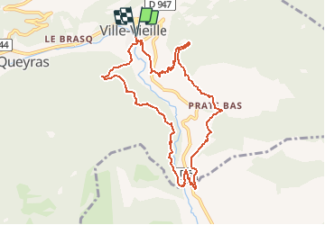
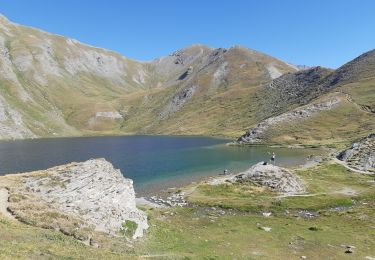
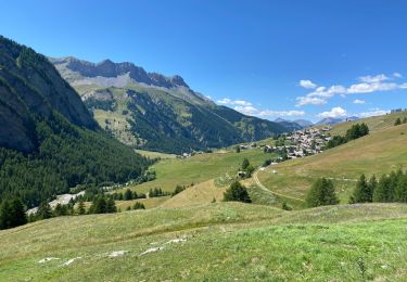
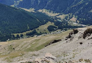
Trail Snowshoes of 9.8 km to be discovered at Provence-Alpes-Côte d'Azur, Hautes-Alpes, Château-Ville-Vieille. This trail is proposed by tracegps.
Description
Belle balade avec un magnifique point de vue de la Demoiselle Coiffée ! Retrouvez d'autres infos sur le site web de Château Ville Vieille .
Positioning
Country:
France
Region :
Provence-Alpes-Côte d'Azur
Department/Province :
Hautes-Alpes
Municipality :
Château-Ville-Vieille
Location:
Unknown
Start:(Dec)
Start:(UTM)
327565 ; 4958633 (32T) N.
Comments
Trails nearby
![Trail Walking Château-Ville-Vieille - Queyras j1 - Photo](https://media.geolcdn.com/t/375/260/78b4351d-2aa3-4d9e-84af-a2a8af3e275c.jpg&format=jpg&maxdim=2)
![Walking Walking](https://static1.geolcdn.com/sitytour/trail-icons/101.png)
Queyras j1
Walking
Medium
(1)
Château-Ville-Vieille,
Provence-Alpes-Côte d'Azur,
Hautes-Alpes,
France
![](/images/other/stat-length.png)
19.1 km | 36 km-effort
8h 6min
![](https://static1.geolcdn.com/siteimages/upload/files/16400158638029165_repeat_loop_refresh_sync_direction_icon.png)
No
![Trail Mountain bike Château-Ville-Vieille - Tour du Queyras - Photo](https://media.geolcdn.com/t/375/260/ext.jpg?maxdim=2&url=https%3A%2F%2Fservices.sitytrail.com%2FGeolivesWS%2FDownloadMedia.ashx%3FTrailID%3D101000%26Media%3D499_1.jpg)
![Mountain bike Mountain bike](https://static1.geolcdn.com/sitytour/trail-icons/202.png)
Tour du Queyras
Mountain bike
Very difficult
(1)
Château-Ville-Vieille,
Provence-Alpes-Côte d'Azur,
Hautes-Alpes,
France
![](/images/other/stat-length.png)
32 km | 50 km-effort
3h 0min
![](https://static1.geolcdn.com/siteimages/upload/files/16400158638029165_repeat_loop_refresh_sync_direction_icon.png)
Yes
![Trail Walking Château-Ville-Vieille - Ville-vieille - Ceillac - Photo](https://media.geolcdn.com/t/375/260/ext.jpg?maxdim=2&url=https%3A%2F%2Fservices.sitytrail.com%2FGeolivesWS%2FDownloadMedia.ashx%3FTrailID%3D629864%26Media%3Dfix__20160909131710.jpg)
![Walking Walking](https://static1.geolcdn.com/sitytour/trail-icons/101.png)
Ville-vieille - Ceillac
Walking
Medium
Château-Ville-Vieille,
Provence-Alpes-Côte d'Azur,
Hautes-Alpes,
France
![](/images/other/stat-length.png)
17.4 km | 31 km-effort
6h 51min
![](https://static1.geolcdn.com/siteimages/upload/files/16400158638029165_repeat_loop_refresh_sync_direction_icon.png)
No
![Trail Walking Aiguilles - les lacs du Malrifs - Photo](https://media.geolcdn.com/t/375/260/ext.jpg?maxdim=2&url=https%3A%2F%2Fservices.sitytrail.com%2FGeolivesWS%2FDownloadMedia.ashx%3FTrailID%3D445852%26Media%3Dfix__20150715135638.jpg)
![Walking Walking](https://static1.geolcdn.com/sitytour/trail-icons/101.png)
les lacs du Malrifs
Walking
Very easy
Aiguilles,
Provence-Alpes-Côte d'Azur,
Hautes-Alpes,
France
![](/images/other/stat-length.png)
11 km | 21 km-effort
4h 44min
![](https://static1.geolcdn.com/siteimages/upload/files/16400158638029165_repeat_loop_refresh_sync_direction_icon.png)
Yes
![Trail Walking Molines-en-Queyras - EMBRUN JOUR 3 : Le Pic du Bûcher (QUEYRAS) - Photo](https://media.geolcdn.com/t/375/260/bda8a7bb-09b2-4591-9392-62db9d13c4b0.jpg&format=jpg&maxdim=2)
![Walking Walking](https://static1.geolcdn.com/sitytour/trail-icons/101.png)
EMBRUN JOUR 3 : Le Pic du Bûcher (QUEYRAS)
Walking
Medium
Molines-en-Queyras,
Provence-Alpes-Côte d'Azur,
Hautes-Alpes,
France
![](/images/other/stat-length.png)
10.2 km | 18.6 km-effort
5h 20min
![](https://static1.geolcdn.com/siteimages/upload/files/16400158638029165_repeat_loop_refresh_sync_direction_icon.png)
Yes
![Trail Walking Aiguilles - lacs malrif à partir du lombard - Photo](https://media.geolcdn.com/t/375/260/d26d85f3-06e6-47dd-a3a6-5aa27f5ad3eb.jpg&format=jpg&maxdim=2)
![Walking Walking](https://static1.geolcdn.com/sitytour/trail-icons/101.png)
lacs malrif à partir du lombard
Walking
Medium
Aiguilles,
Provence-Alpes-Côte d'Azur,
Hautes-Alpes,
France
![](/images/other/stat-length.png)
9.8 km | 19.4 km-effort
3h 45min
![](https://static1.geolcdn.com/siteimages/upload/files/16400158638029165_repeat_loop_refresh_sync_direction_icon.png)
Yes
![Trail Walking Château-Ville-Vieille - 05-pointe-du-Rasis-13km-760m-aout21 - Photo](https://media.geolcdn.com/t/375/260/ab196ec4-46c6-451a-a3c4-d57666189769.jpg&format=jpg&maxdim=2)
![Walking Walking](https://static1.geolcdn.com/sitytour/trail-icons/101.png)
05-pointe-du-Rasis-13km-760m-aout21
Walking
Difficult
Château-Ville-Vieille,
Provence-Alpes-Côte d'Azur,
Hautes-Alpes,
France
![](/images/other/stat-length.png)
13.2 km | 23 km-effort
5h 32min
![](https://static1.geolcdn.com/siteimages/upload/files/16400158638029165_repeat_loop_refresh_sync_direction_icon.png)
Yes
![Trail Electric bike Molines-en-Queyras - Le Coin Pic Château Renard Refugd et lac de la Blanche et tête - Photo](https://media.geolcdn.com/t/375/260/019f17ed-3494-4178-8765-b24792ecc649.jpg&format=jpg&maxdim=2)
![Electric bike Electric bike](https://static1.geolcdn.com/sitytour/trail-icons/205.png)
Le Coin Pic Château Renard Refugd et lac de la Blanche et tête
Electric bike
Difficult
Molines-en-Queyras,
Provence-Alpes-Côte d'Azur,
Hautes-Alpes,
France
![](/images/other/stat-length.png)
43 km | 64 km-effort
6h 12min
![](https://static1.geolcdn.com/siteimages/upload/files/16400158638029165_repeat_loop_refresh_sync_direction_icon.png)
Yes
![Trail Walking Molines-en-Queyras - Pierre-Grosse - Guardiole de l'Alp - Com du clos du Loup - Photo](https://media.geolcdn.com/t/375/260/a62e972d-9d3f-4e82-bdc5-c4c46a5a157b.jpg&format=jpg&maxdim=2)
![Walking Walking](https://static1.geolcdn.com/sitytour/trail-icons/101.png)
Pierre-Grosse - Guardiole de l'Alp - Com du clos du Loup
Walking
Difficult
Molines-en-Queyras,
Provence-Alpes-Côte d'Azur,
Hautes-Alpes,
France
![](/images/other/stat-length.png)
11.9 km | 24 km-effort
3h 25min
![](https://static1.geolcdn.com/siteimages/upload/files/16400158638029165_repeat_loop_refresh_sync_direction_icon.png)
Yes