![](/images/other/stat-length.png)
![Trail Walking La Ferté-Saint-Cyr - Circuit des étangs à La Ferte St Cyr - Photo](https://media.geolcdn.com/t/1900/400/ext.pjpeg?maxdim=2&url=https%3A%2F%2Fstatic1.geolcdn.com%2Fsiteimages%2Fupload%2Ffiles%2F1553511878bg_sport_marche.png)
Circuit des étangs à La Ferte St Cyr
migauthi
User
![Length](/images/other/stat-length.png)
Length
13.4 km
![Max alt](https://static1.geolcdn.com/siteimages/upload/files/1508320355ic_sort_altitude_max_24dp.png)
Max alt
109 m
![Uphill gradient](https://static1.geolcdn.com/siteimages/upload/files/1508320355ic_sort_den_pos_24dp.png)
Uphill gradient
99 m
![Km-Effort](/images/other/stat-length.png)
Km-Effort
14.7 km
![Min alt](https://static1.geolcdn.com/siteimages/upload/files/1508320355ic_sort_altitude_min_24dp.png)
Min alt
82 m
![Downhill gradient](https://static1.geolcdn.com/siteimages/upload/files/1508320355ic_sort_den_neg_24dp.png)
Downhill gradient
100 m
![Boucle](https://static1.geolcdn.com/siteimages/upload/files/16400158638029165_repeat_loop_refresh_sync_direction_icon.png)
Boucle
Yes
Creation date :
2019-02-10 20:49:54.575
Updated on :
2019-02-10 20:49:54.604
![Walking](https://static1.geolcdn.com/sitytour/trail-icons/101.png)
3h15
Difficulty : Very easy
![Scan this QR Code to open this trail in the SityTrail application](https://capi.geolives.com/qq0zvz2zws4bq2lad0pu/sitytour/trails/191153/qr.png?size=200)
FREE GPS app for hiking
About
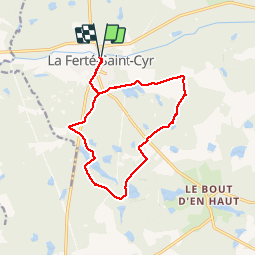
Trail Walking of 13.4 km to be discovered at Centre-Loire Valley, Loir-et-Cher, La Ferté-Saint-Cyr. This trail is proposed by migauthi.
Description
Très agréable rando en sous-bois. Superbes etangs tout au long du parcours. Peut être réduit de 2 km en partant du lieu-dit " La Platine"
Positioning
Country:
France
Region :
Centre-Loire Valley
Department/Province :
Loir-et-Cher
Municipality :
La Ferté-Saint-Cyr
Location:
Unknown
Start:(Dec)
Start:(UTM)
400379 ; 5278959 (31T) N.
Comments
Trails nearby
![Trail sport La Ferté-Saint-Cyr - Sob 8 ferte St Cyr bracieux - Photo](https://media.geolcdn.com/t/375/260/d3287ec2-2d6e-44da-8827-b826827e66a5.jpg&format=jpg&maxdim=2)
Sob 8 ferte St Cyr bracieux
sport
Very easy
La Ferté-Saint-Cyr,
Centre-Loire Valley,
Loir-et-Cher,
France
![](/images/other/stat-length.png)
26 km | 29 km-effort
Unknown
![](https://static1.geolcdn.com/siteimages/upload/files/16400158638029165_repeat_loop_refresh_sync_direction_icon.png)
No
![Trail Walking Crouy-sur-Cosson - crouy sur cosson - Photo](https://media.geolcdn.com/t/375/260/ext.jpg?maxdim=2&url=https%3A%2F%2Fstatic1.geolcdn.com%2Fsiteimages%2Fupload%2Ffiles%2F1553511878bg_sport_marche.png)
![Walking Walking](https://static1.geolcdn.com/sitytour/trail-icons/101.png)
crouy sur cosson
Walking
Easy
Crouy-sur-Cosson,
Centre-Loire Valley,
Loir-et-Cher,
France
![](/images/other/stat-length.png)
13.9 km | 15.3 km-effort
2h 58min
![](https://static1.geolcdn.com/siteimages/upload/files/16400158638029165_repeat_loop_refresh_sync_direction_icon.png)
Yes
![Trail Walking Crouy-sur-Cosson - crouy sur Cosson - Photo](https://media.geolcdn.com/t/375/260/ext.jpg?maxdim=2&url=https%3A%2F%2Fstatic1.geolcdn.com%2Fsiteimages%2Fupload%2Ffiles%2F1553511878bg_sport_marche.png)
![Walking Walking](https://static1.geolcdn.com/sitytour/trail-icons/101.png)
crouy sur Cosson
Walking
Very easy
Crouy-sur-Cosson,
Centre-Loire Valley,
Loir-et-Cher,
France
![](/images/other/stat-length.png)
6.3 km | 7 km-effort
1h 23min
![](https://static1.geolcdn.com/siteimages/upload/files/16400158638029165_repeat_loop_refresh_sync_direction_icon.png)
Yes
![Trail Walking La Ferté-Saint-Cyr - La Ferte St Cyr 41 - Photo](https://media.geolcdn.com/t/375/260/ext.jpg?maxdim=2&url=https%3A%2F%2Fstatic1.geolcdn.com%2Fsiteimages%2Fupload%2Ffiles%2F1553511878bg_sport_marche.png)
![Walking Walking](https://static1.geolcdn.com/sitytour/trail-icons/101.png)
La Ferte St Cyr 41
Walking
Easy
La Ferté-Saint-Cyr,
Centre-Loire Valley,
Loir-et-Cher,
France
![](/images/other/stat-length.png)
13.3 km | 14.7 km-effort
3h 14min
![](https://static1.geolcdn.com/siteimages/upload/files/16400158638029165_repeat_loop_refresh_sync_direction_icon.png)
Yes
![Trail Walking La Ferté-Saint-Cyr - La Ferté St Cyr-les étangs - Photo](https://media.geolcdn.com/t/375/260/ext.jpg?maxdim=2&url=https%3A%2F%2Fstatic1.geolcdn.com%2Fsiteimages%2Fupload%2Ffiles%2F1553511878bg_sport_marche.png)
![Walking Walking](https://static1.geolcdn.com/sitytour/trail-icons/101.png)
La Ferté St Cyr-les étangs
Walking
Easy
La Ferté-Saint-Cyr,
Centre-Loire Valley,
Loir-et-Cher,
France
![](/images/other/stat-length.png)
17.9 km | 19.8 km-effort
4h 22min
![](https://static1.geolcdn.com/siteimages/upload/files/16400158638029165_repeat_loop_refresh_sync_direction_icon.png)
Yes
![Trail Walking La Ferté-Saint-Cyr - Ligny_La Ferte Saint Cyr_Villabry - Photo](https://media.geolcdn.com/t/375/260/ext.jpg?maxdim=2&url=https%3A%2F%2Fstatic1.geolcdn.com%2Fsiteimages%2Fupload%2Ffiles%2F1553511878bg_sport_marche.png)
![Walking Walking](https://static1.geolcdn.com/sitytour/trail-icons/101.png)
Ligny_La Ferte Saint Cyr_Villabry
Walking
Easy
La Ferté-Saint-Cyr,
Centre-Loire Valley,
Loir-et-Cher,
France
![](/images/other/stat-length.png)
9.6 km | 10.5 km-effort
2h 1min
![](https://static1.geolcdn.com/siteimages/upload/files/16400158638029165_repeat_loop_refresh_sync_direction_icon.png)
Yes
![Trail Walking La Ferté-Saint-Cyr - La Ferté St Cyr à l'envers - Photo](https://media.geolcdn.com/t/375/260/ext.jpg?maxdim=2&url=https%3A%2F%2Fstatic1.geolcdn.com%2Fsiteimages%2Fupload%2Ffiles%2F1553511878bg_sport_marche.png)
![Walking Walking](https://static1.geolcdn.com/sitytour/trail-icons/101.png)
La Ferté St Cyr à l'envers
Walking
Difficult
La Ferté-Saint-Cyr,
Centre-Loire Valley,
Loir-et-Cher,
France
![](/images/other/stat-length.png)
12.6 km | 14 km-effort
3h 10min
![](https://static1.geolcdn.com/siteimages/upload/files/16400158638029165_repeat_loop_refresh_sync_direction_icon.png)
Yes
![Trail Walking La Ferté-Saint-Cyr - La ferte St Cyr 9 km - Photo](https://media.geolcdn.com/t/375/260/ext.jpg?maxdim=2&url=https%3A%2F%2Fstatic1.geolcdn.com%2Fsiteimages%2Fupload%2Ffiles%2F1553511878bg_sport_marche.png)
![Walking Walking](https://static1.geolcdn.com/sitytour/trail-icons/101.png)
La ferte St Cyr 9 km
Walking
Medium
La Ferté-Saint-Cyr,
Centre-Loire Valley,
Loir-et-Cher,
France
![](/images/other/stat-length.png)
9.1 km | 10 km-effort
2h 16min
![](https://static1.geolcdn.com/siteimages/upload/files/16400158638029165_repeat_loop_refresh_sync_direction_icon.png)
Yes
![Trail Road bike Crouy-sur-Cosson - Activity - Photo](https://media.geolcdn.com/t/375/260/ext.jpg?maxdim=2&url=https%3A%2F%2Fstatic1.geolcdn.com%2Fsiteimages%2Fupload%2Ffiles%2F1524743154velo.jpg)
![Road bike Road bike](https://static1.geolcdn.com/sitytour/trail-icons/201.png)
Activity
Road bike
Difficult
Crouy-sur-Cosson,
Centre-Loire Valley,
Loir-et-Cher,
France
![](/images/other/stat-length.png)
30 km | 33 km-effort
2h 0min
![](https://static1.geolcdn.com/siteimages/upload/files/16400158638029165_repeat_loop_refresh_sync_direction_icon.png)
Yes
Circuit très agréable et facile